Costa Rica’s coastal destinations, including Pacific and Caribbean beaches. Features surfing spots, swimming areas, and coastal towns. From popular tourist beaches to hidden coves.
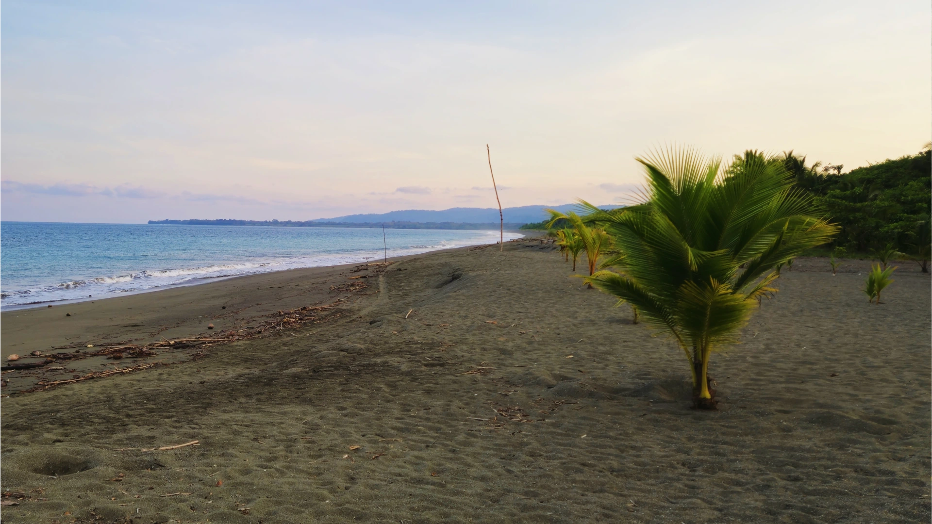
Costa Rica’s Pacific coast has countless adventures for travelers, but few areas balance authentic charm and family friendly activities like Dominical. This laid back surf town and its surrounding hidden gems provide budget conscious travelers with amazing experiences. All this without the crowds or high prices found in more touristy destinations.
Just three hours from San Jose, Dominical is a perfect base for exploring great beaches, wild swimming holes, and local culture. Families particularly love this area for its mix of gentle beach areas where kids can play safely and accessible wildlife viewing opportunities that don’t require expensive tours.
While Dominical has grown in popularity over recent years, it still maintains its relaxed vibe and has plenty of affordable accommodation, food options, and free natural attractions. In this guide and the Youtube videos, we’ll go over how get around the area, finding the budget friendly spots where your family can create unforgettable Costa Rican memories without emptying your wallet.
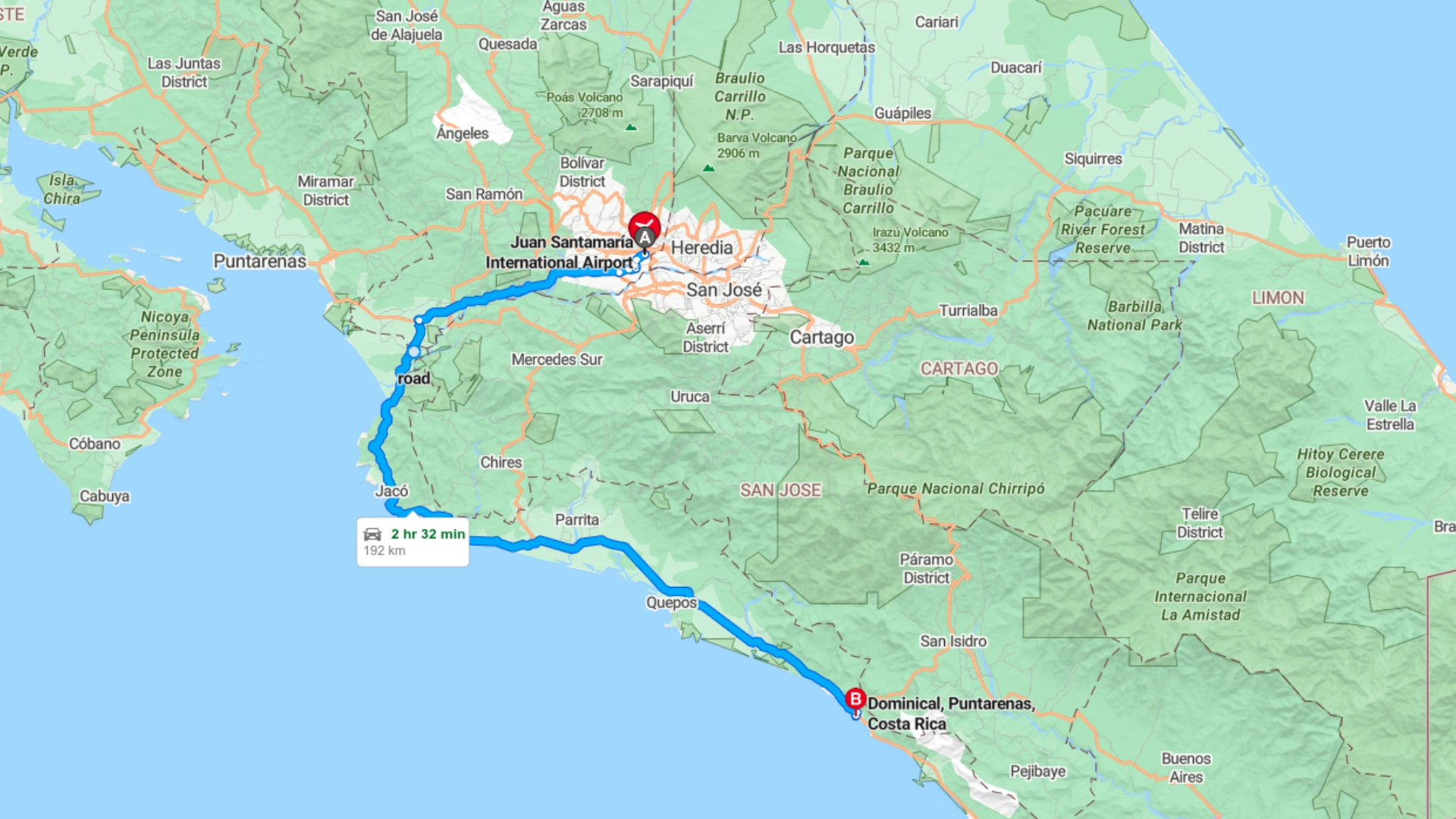
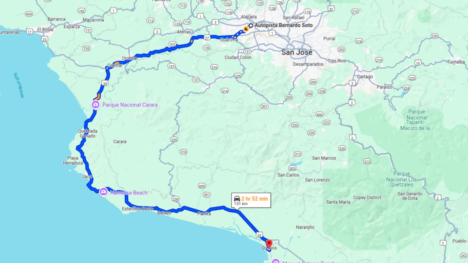
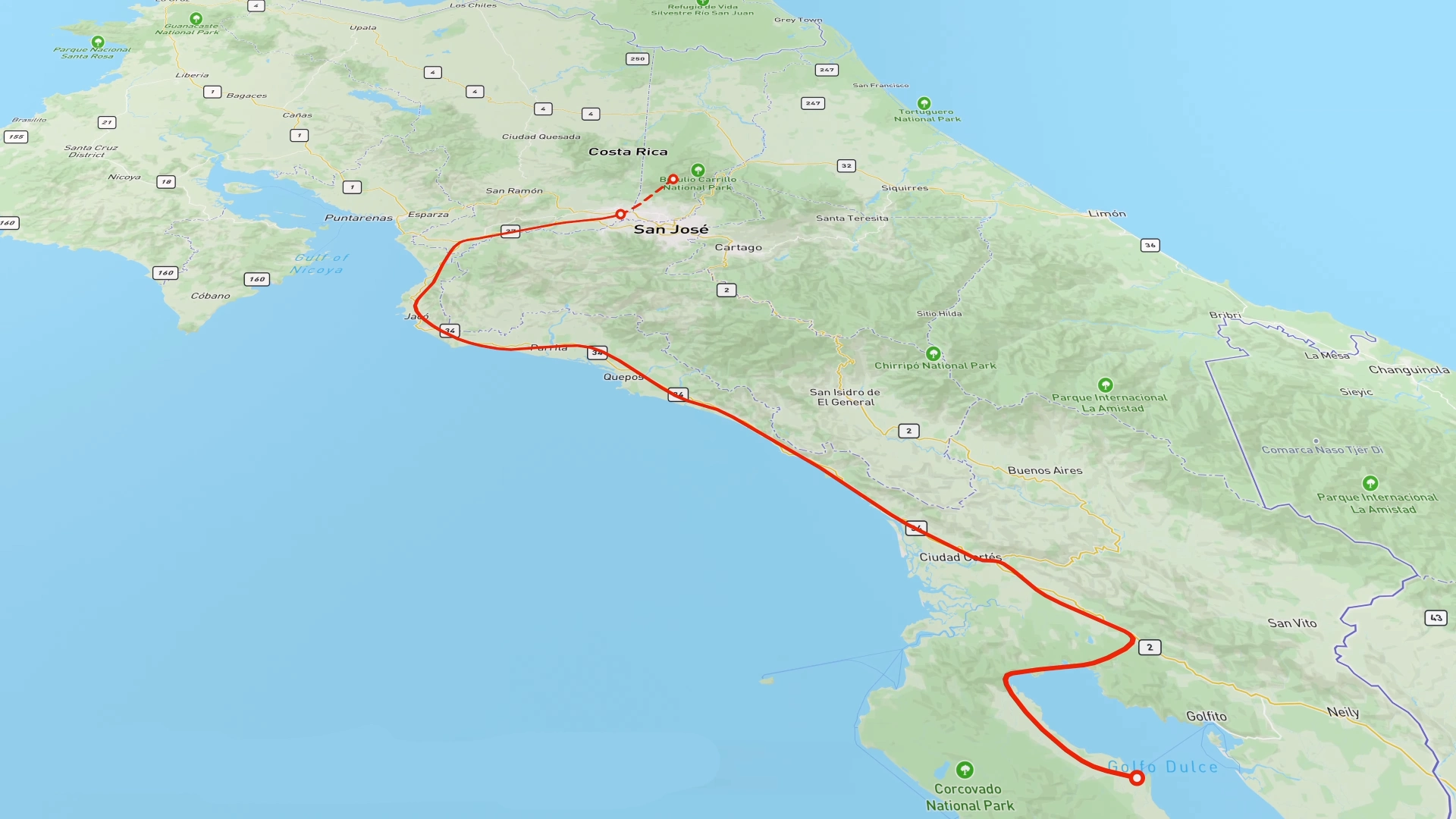
Getting to Dominical from San Jose takes about 3 hours by car, making it an accessible destination for families even with young children. The route goes along well maintained highways for most of the journey, with Highway 34 taking you along the coast for the final stretch.
Having your own transportation is highly recommended for exploring this region, as many of the best spots aren’t available with public transit. While shuttle services are available from San Jose, they limit your ability to discover the hidden gems that make this area special.
The route from San Jose to Dominical will take about 3 hours with minimal traffic. You’ll pass by popular spots like Jaco and Quepos/Manuel Antonio.
San Jose to Dominical: The Scenic Route
Your drive begins at San Jose International Airport where you’ll head west toward the Pacific coast. After passing through Orotina, you’ll continue south trhough Jaco and Parrita before driving by Quepos/Manuel Antonio. Each of these towns makes a good rest stop, with Jaco having plenty of family friendly restaurants about halfway through your drive.
As you approach Dominical, you’ll notice the landscape become increasingly lush and the traffic thin out. The final 30 minutes of driving takes you past beautiful coastal views with several pull offs where you can safely stop for photos. Watch for the Dominical sign at the main entrance to town – it’s a popular spot for a quick picture to mark the start of your adventure.
Transportation Options & Practical Tips
Rental cars give you the most flexibility, with 4WD or higher clearance vehicles recommended if you plan to explore beyond the main roads. Budget conscious travelers can opt for a standard sedan if staying primarily on highways and main beach roads, but you’ll miss some of the more secluded spots where rougher roads lead to empty beaches.
For families traveling on a tight budget, taking the public bus from San Jose to Dominical costs about $15 per person, though the journey takes closer to 4 hours with stops. If you choose this option, consider renting a car locally for just a day or two to visit the harder to reach beaches and swimming holes, then use taxis or walking for exploring the main town area.
Pick up a pair of these awesome water shoes. I’ve been using them all over Costa Rica during my travels. They have vented soles so water drains right out the bottom!
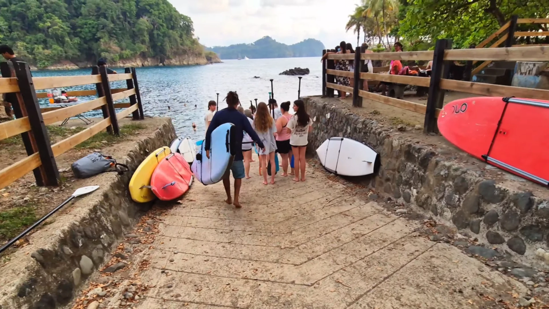
Hidden Beach Gems Near Dominical
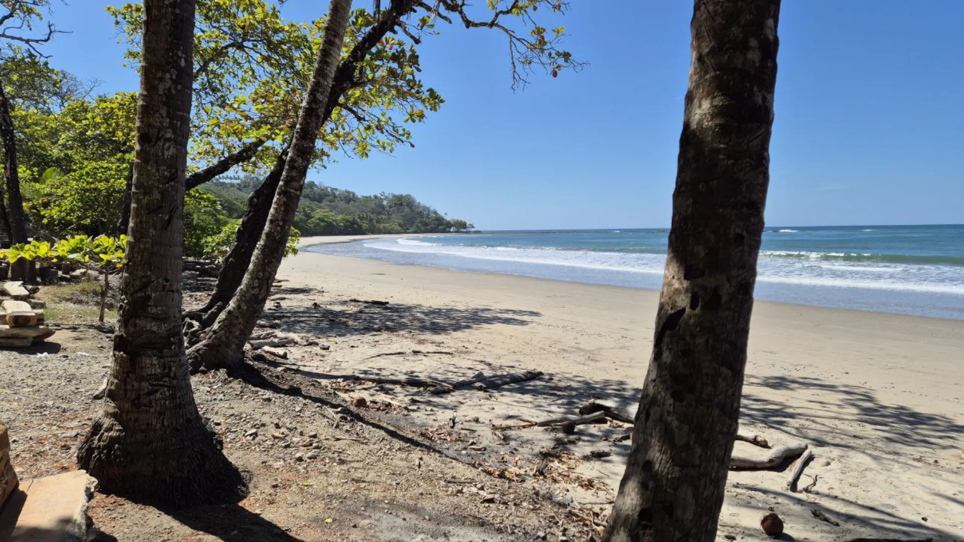
While Dominical’s main beach attracts surfers with its consistent waves, families with young children will find more suitable swimming spots at the lesser known beaches nearby. These hidden gems have gentler waters, natural tide pools, and fewer crowds, creating perfect environments for relaxed family beach days.
Most of these beaches are within a 15-minute drive from Dominical town center, making them easy half day trips. Pack snacks, water, and basic supplies as some have minimal facilities, which helps keep them less crowded and more affordable than developed beach areas.
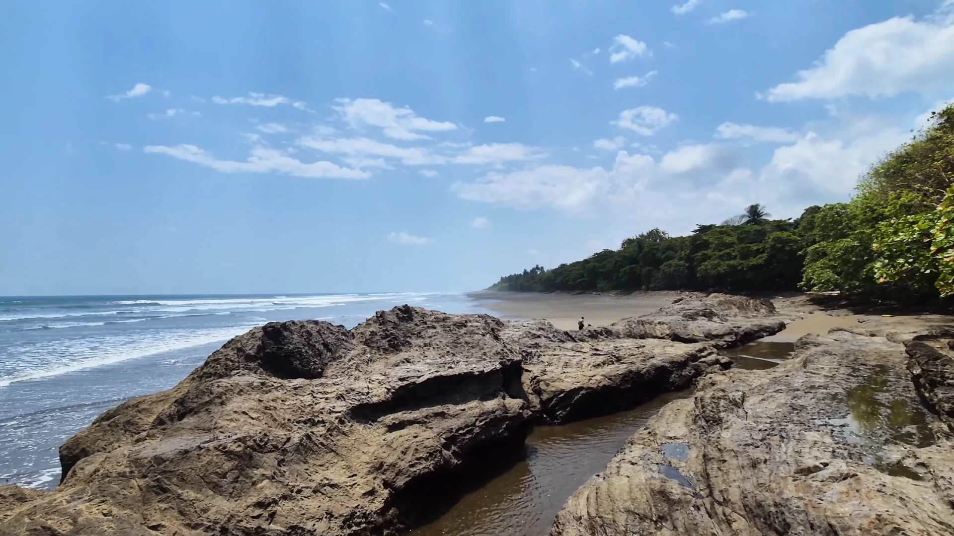
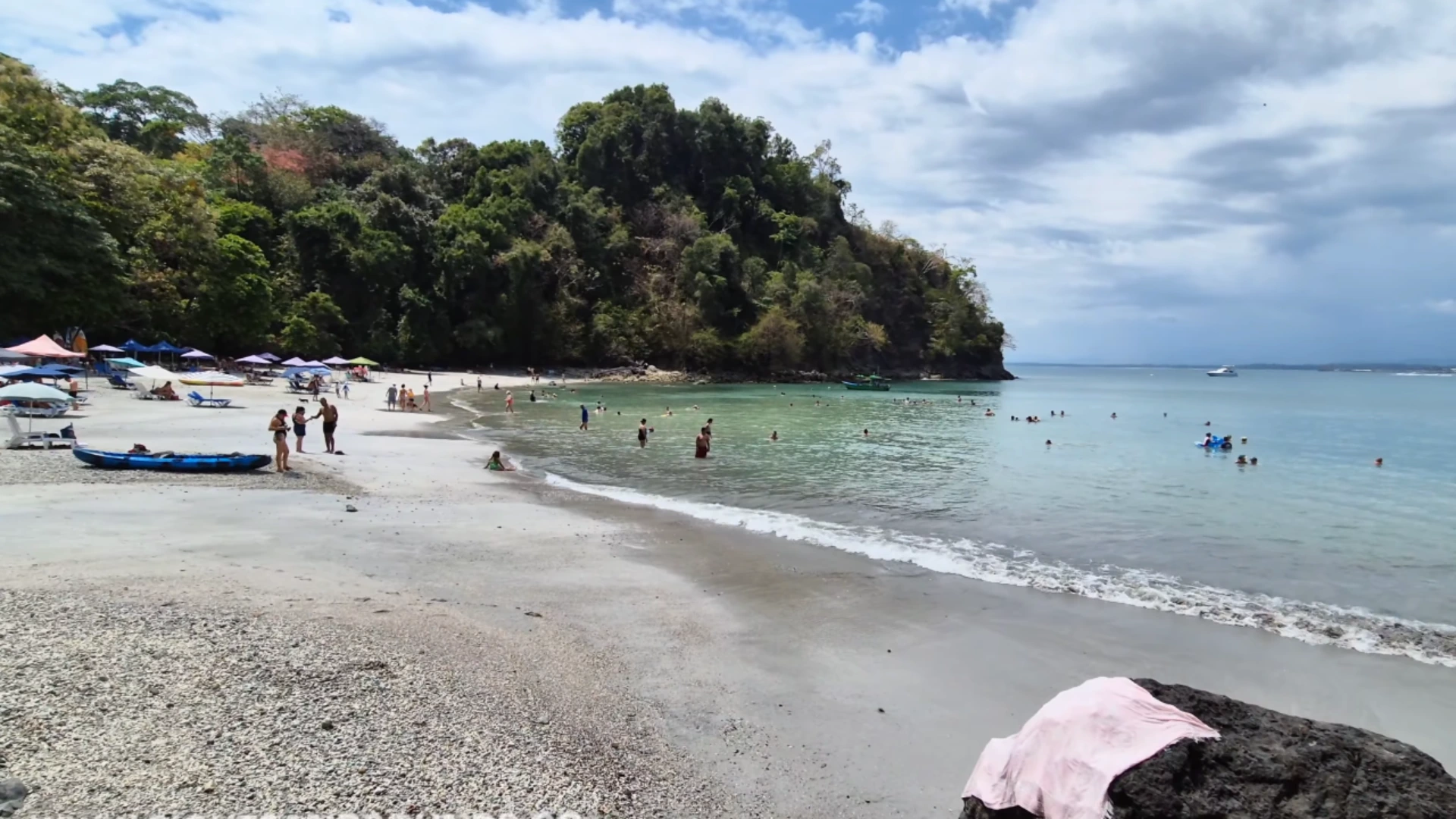
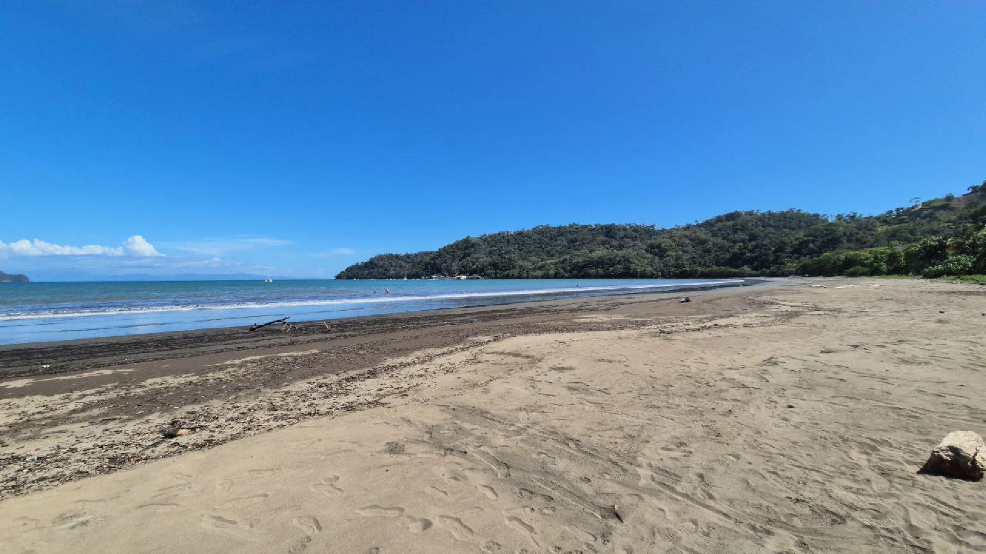
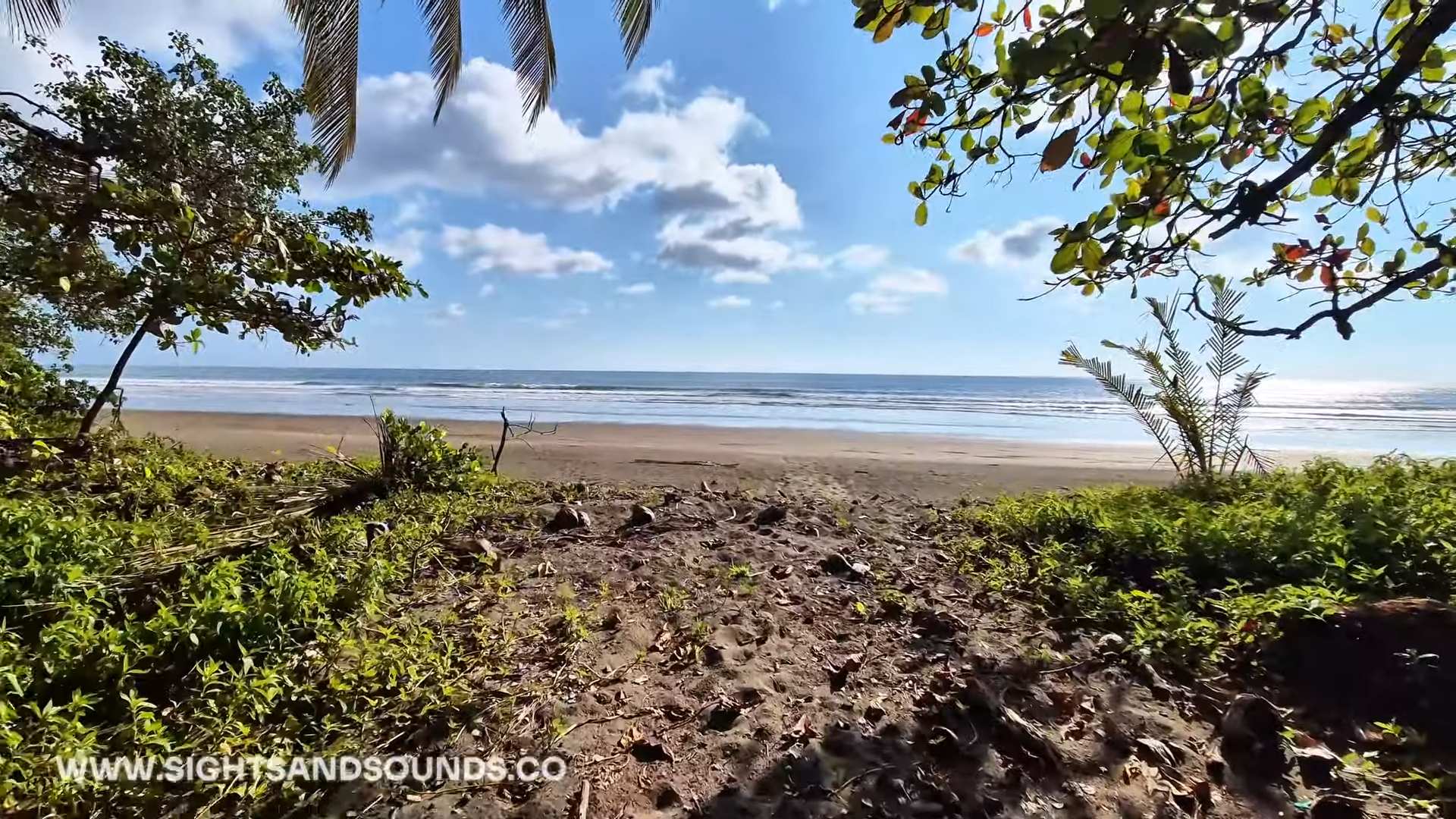
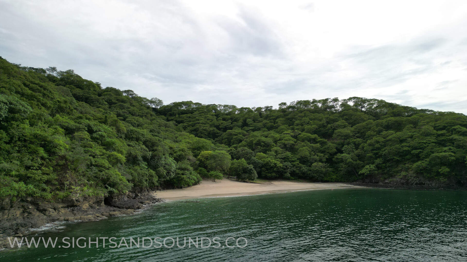
Dominicalito: A Tranquil Alternative
Just 5 minutes south of Dominical, you’ll find Dominicalito Beach – a smaller, more sheltered cove with calmer waters and amazing views. The beach has natural rock formations at both ends that create protected swimming areas where kids can play safely, especially at low tide when shallow pools form among the rocks.
To reach Dominicalito, there are several turns offs the main highway after you leave Dominical. In the video, I park at one of the more accesible lots which is right off the highway. Some of the other entraces to the beach have variable quality roads which may require a high ground clearance. Once parked, a short path leads you to this peaceful stretch of sand where you’ll find fewer people enjoying the beach.
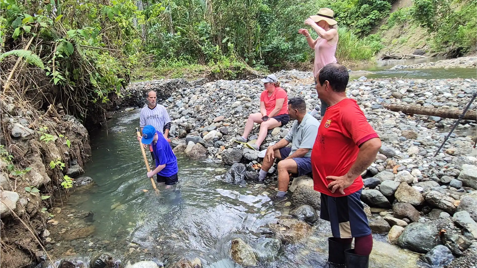
Poza Azul & Secret Swimming Holes
For a refreshing break from saltwater, Poza Azul provides a natural freshwater swimming experience just minutes from Dominical. This river pool has cold river water and is deep enough for swimming in several spots, but also has shallow areas perfect for younger children to splash around safely.
To find Poza Azul, drive through the small town of Dominicalito and watch for a right turn about 50 meters after crossing a small bridge. Follow the dirt road for a short distance to a parking area where you’ll sometimes find a local parking caretaker (tipping 1000 colones is appreciated). From there, a somewhat steep but short path leads down to the swimming hole where rope swings and jumping rocks add excitement for older kids and teens.
Budget-Friendly Family Activities
Dominical may be small, but it packs a surprising number of affordable activities that families can enjoy without breaking the bank. Many of the area’s best experiences cost nothing at all or require only a small fee, giving budget conscious travelers plenty of options.
One of the keys to keeping costs down in this area is taking advantage of natural attractions like beaches and rivers during mornings and late afternoons, then planning visits to markets and town areas during the midday heat. This approach maximizes enjoyment while minimizing spending on paid cooling activities.
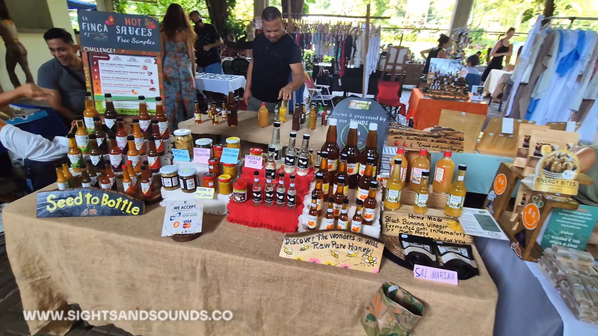
Dominical Eco Feria: Local Market Experience
The Dominical Eco Feria (farmers market) runs every Friday from morning until early afternoon near the center of town, bringing together local farmers, artisans, and food vendors. You’ll enjoy sampling fresh tropical fruits that you may never have seen before.
Beyond just shopping, the market has a festive atmosphere with occasional live music and a central seating area where you can enjoy fresh juices and prepared foods. Arrive around 10 AM for the fullest experience, and bring small bills and coins for easier transactions. Even if you’re not buying much, this free activity provides authentic cultural immersion and insight into local Costa Rican life.
Nature Encounters: Rivers, Waterfalls & Wildlife
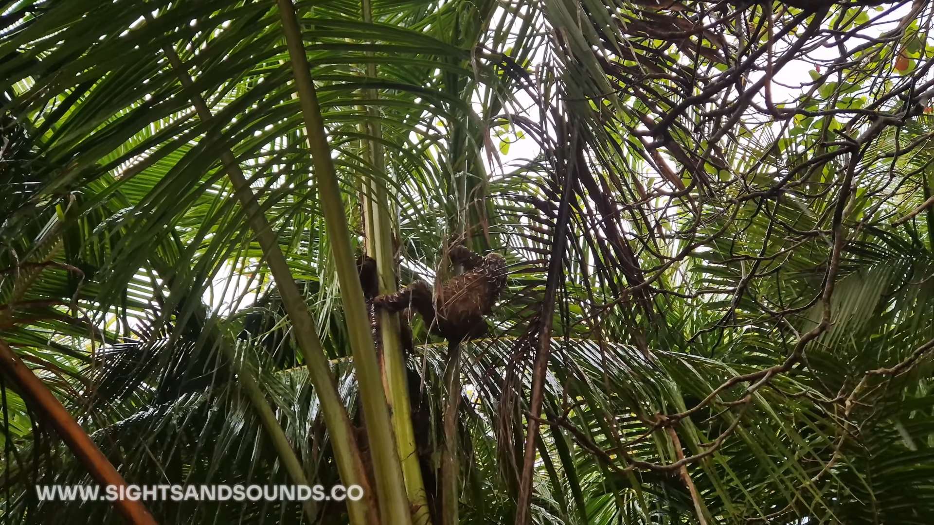
The area around Dominical has several spots where wildlife viewing comes at no cost. The estuary at the north end of Dominical beach frequently has scarlet macaws flying overhead, especially in early morning hours. Walk quietly along the paths near the river mouth and you might spot basilisk lizards (often called “Jesus Christ lizards” for their ability to run across water) or families of howler monkeys in the trees.
Sloth spotting has become a popular activity in Dominical, with these slow-moving mammals often visible in the trees around town. Early mornings and late afternoons tend to be when sloths are most active, though “active” for a sloth might just mean moving from one branch to another. Check the cecropia trees along the main road into town, particularly near Dominical Surf School and the entrance to the beach area, where sloths are frequently spotted. Bring binoculars if you have them, but even without, patient observation of tree canopies can reward you with these gentle creatures’ surprisingly sweet faces.
If these blog posts and videos help plan your Costa Rica vacation, please support our channel.
Follow Us
Keep up with our latest Costa Rica travel videos and guides by subscribing to our YouTube channel. We regularly post new content showing real conditions across different regions and seasons.
Leave a comment with your Costa Rica travel questions – we’re happy to help plan your perfect time to visit.
Frequently Asked Questions
When is the best time to visit Dominical?
The dry season from December to April has the most reliable weather for beach activities, but comes with higher prices and more crowds. The “green season” from May to November has afternoon showers but fewer tourists and lower prices. September and October see the most rainfall and some businesses may close.
Is Dominical safe for families?
Yes, Dominical is generally very safe for family travel. The main precautions include standard beach safety (watching for rip currents), protecting valuables at the beach, and using insect repellent. Locals are friendly and accustomed to tourists.
Do I need a 4×4 vehicle to explore the Dominical area?
Not necessarily, but it’s helpful. The main roads are paved and accessible with any vehicle. However, reaching some beaches like Dominicalito and attractions like Poza Azul requires driving on short stretches of gravel or dirt roads that can become rough after rain. A vehicle with higher clearance is recommended but not essential during dry season.
Where can I find affordable food in Dominical?
The Eco Feria (Friday market) has the best value for fresh produce and prepared foods. For daily meals, try “sodas” (small local restaurants) like Soda Delicias where a filling casado plate costs around $6-8. The supermarket in town has reasonable prices for self-catering, and many beach accommodations come with kitchens.
Are there ATMs in Dominical?
Yes, there’s an ATM at the Banco de Costa Rica in town, but it occasionally runs out of cash during busy periods. It’s wise to bring some cash from larger towns like Uvita or Quepos. Many businesses accept credit cards, but smaller vendors and some restaurants may be cash-only.
Can I drink the water in Dominical?
The tap water in most established accommodations is safe to drink. However, if staying in very remote areas or if you have a sensitive stomach, bottled water is readily available. Bringing a reusable water bottle with a filter is both economical and environmentally friendly.
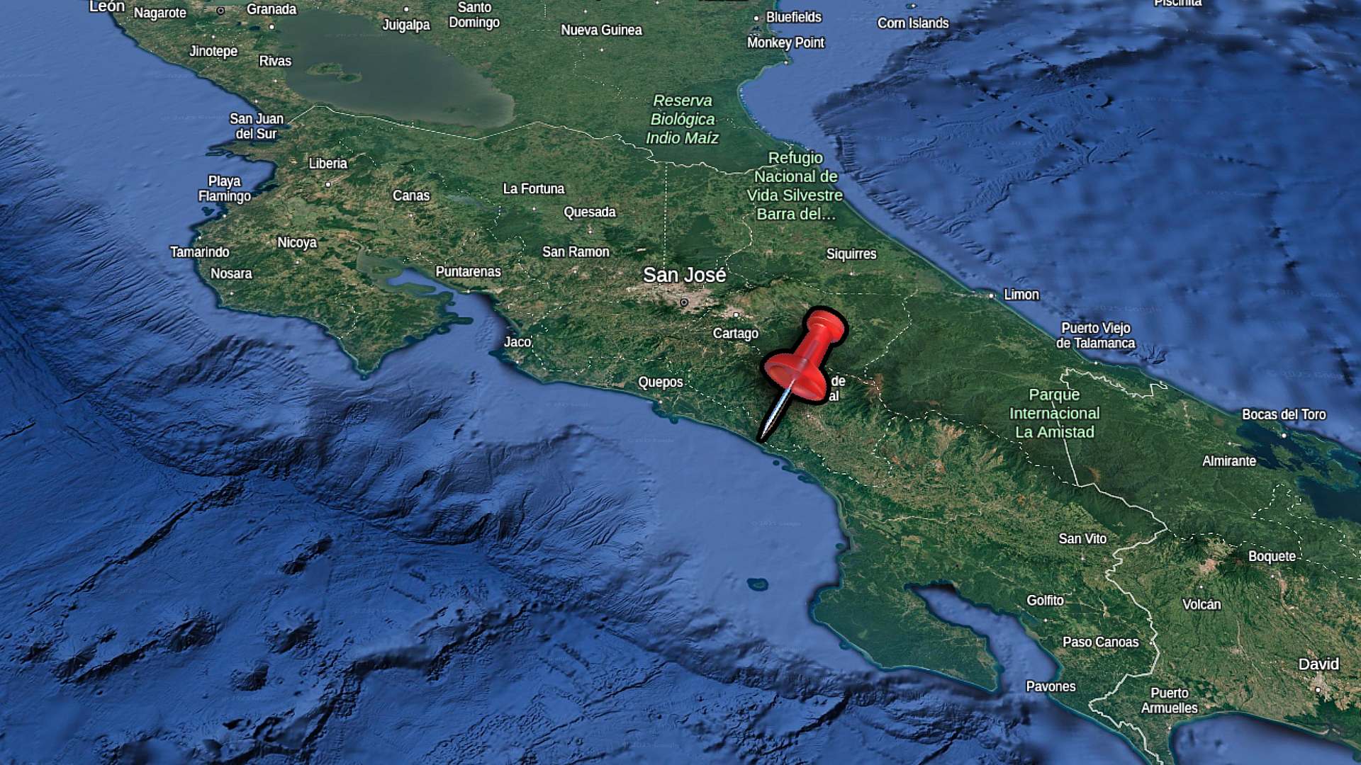
Costa Rica’s Southern Zone is a perfect mix of stunning Pacific beaches, misty mountains, and authentic towns still untouched by mass tourism. While many visitors to Costa Rica stick to the popular destinations in Guanacaste or the Central Valley, if you venture south you’ll be rewarded with fewer crowds, lower prices, and some of the country’s most breathtaking scenery.
The journey through this region takes you from the surfing beaches of Dominical to the large commercial center of San Isidro de El General. Further south you’ll find the indigenous heartland around Buenos Aires. Along the way, you’ll drive through mountains where pine trees and palms can be seen within a single hour’s drive. Pass by countless rivers flowing from the mountains and spot roadside sodas serving up delicious casados for a fraction of resort prices.
Whether you’re planning a surf trip, looking to explore hot springs within indigenous territories, or simply want to see a less busy side of Costa Rica – the Southern Zone is for you. The roads might be winding and the towns less polished, but that’s exactly what makes this region special for travelers willing to go beyond the familiar tourist path.
Travel Tip: You don’t need to buy a SIM card when you land in Costa Rica to get data connection. With an eSIM, you’ll be able to configure your data connection before you depart for your vacation. I use the Saily eSIM in Costa Rica.
The Southern Zone of Costa Rica runs along the Pacific coast and inland mountains south of the Central Valley. This region stretches from Manuel Antonio and Dominical down to the Panamanian border, including both coastal areas and the interior highlands. Unlike the more developed northern Pacific region of Guanacaste, the Southern Zone maintains a rawer, less commercialized feel that many travelers find refreshing.
To reach this region, you’ll likely start at San José International Airport. From there, you’ll head south over what locals sometimes call the “winding Hill of Death” (don’t worry, it’s just a dramatic name for the mountain pass). The drive from San José to San Isidro takes about 3 hours, while continuing to Dominical on the coast adds another hour. If you’re heading to Buenos Aires, you’ll drive about 4 hours from San José through agricultural lands and indigenous territories.
What makes the Southern Zone unique is how quickly the landscape changes. Within a single hour’s drive, you can go from cool mountain pine forests to hot, humid coastal jungles. The region is home to the Talamanca Mountain Range, which is the backbone of southern Costa Rica and creates dramatic valleys, rivers, and microclimates throughout the area.
When to Visit the Southern Zone
The Southern Zone has distinct weather patterns that differ from other parts of Costa Rica. The dry season runs from December through April, offering sunny days perfect for beach activities in Dominical and easier driving conditions on mountain roads. January and February tend to be the busiest months, though even then, this region sees far fewer tourists than Guanacaste or Manuel Antonio.
Rainy season (or “green season”) runs from May through November, with September and October typically seeing the heaviest rainfall. During these months, expect afternoon downpours that can make mountain roads more challenging.
However, mornings are often clear, and the landscapes turn incredibly lush. The rain also brings out wildlife and creates powerful waterfalls throughout the region. If you visit during these months, plan outdoor activities for morning hours and keep flexible afternoon plans.
Temperature varies dramatically with elevation in the Southern Zone. Coastal Dominical stays hot year-round (around 27-32°C). San Isidro at 2,300 feet elevation enjoys a pleasant “eternal spring” climate with temperatures between 18-27°C. As you climb the mountains between towns, temperatures can drop significantly, so pack layers if you plan to explore different elevations. Many visitors notice the temperature change immediately when driving through this region – you’ll feel the humidity and heat hit you suddenly as you descend from the mountains toward the coast.
I use this sling backpack when I’m travelling in Costa Rica. It has a zipper lock to secure your stuff. I like the sling as I can flip the bag to the front for easy access.
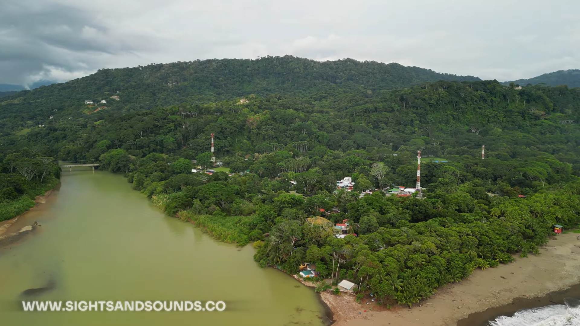
Dominical: Surf Town by the Pacific
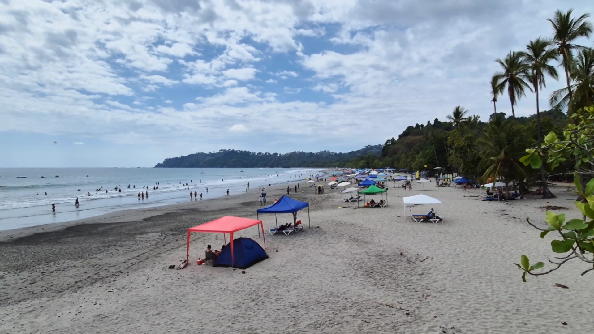
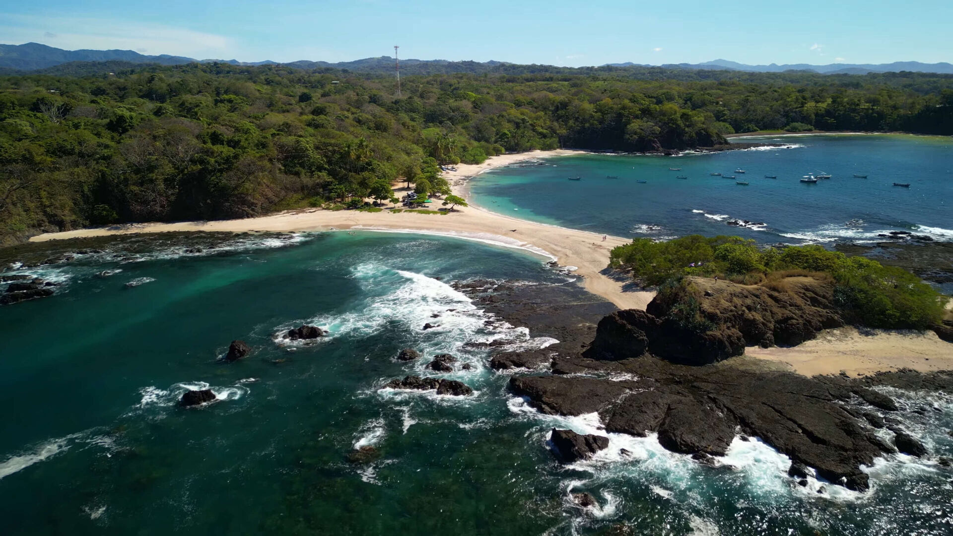
Dominical has a way of sticking with you. Arriving after winding down from the mountains, you’re immediately greeted by that distinct coastal heat and humidity. This small beach town consists of one main road running towards powerful waves breaking on a dark sand beach. You won’t find major resorts here. Instead, Dominical has a mix of surf shops, family owned restaurants, and a diverse crowd. Surfers, travelers, and local families enjoying the Pacific shore.
The town has grown gradually over the years without losing its character. The addition of the BM supermarket outside town is a welcome convenience for stays of more than a day or two. Vendors still set up along the beach road daily, selling handcrafted items, jewelry, and clothing. What makes Dominical truly special is the dramatic backdrop – surfing here means looking up at green mountains that rise sharply from the coastline, creating a striking contrast between ocean blue and jungle green.
Getting to Dominical
Two routes lead to Dominical, each having different experiences. From San José, take Highway 27 west toward Jacó, then turn south on Highway 34 along the coast. This journey typically takes about 3.5 hours on well maintained roads, with pleasant ocean views accompanying the southern portion of the drive.
The mountain route from San Isidro is a more scenic ride. This winding road takes you through the highlands and small towns like Tinamastes and Platanillo, with the climate changing noticeably as you descend. The temperature starts cooler in San Isidro, then gradually warms as you approach the coast. Several lookout points along the way provide panoramic views of the coastline on clear days. The drive is roughly 45 minutes without stops, but allowing time for viewpoints is worthwhile.
Upon reaching Dominical, navigation becomes simple. The town spans just a few blocks, making it entirely walkable. Parking can become challenging during peak season, especially on weekends when visitors from nearby towns arrive for beach days.
Top Activities in Dominical
Surfing is Dominical’s primary draw. The consistent waves have built the town’s reputation among surf enthusiasts. The main beach has stronger breaks that attract experienced surfers, while beginners find more forgiving conditions slightly north of town. Several schools offer lessons ranging from $50-60, with instructors providing hands on guidance to newcomers.
The beach itself deserves attention even for non-surfers. While not the pristine white sand type found in travel brochures, Dominical’s shoreline has its own character. At low tide, natural rock pools form to the south end, creating safe areas for children to enjoy the water away from the powerful waves. The addition of lifeguards during busy periods provides essential safety given the strong currents.
Wildlife viewing opportunities are both in and around town. You can occasionally spot sloths in trees near the beach area, particularly after rain showers. The nearby Hacienda Barú wildlife refuge offers more structured nature experiences, and whale watching tours operate during migration seasons (December-April and July-November), providing opportunities to observe these magnificent marine mammals in their natural habitat.
Mountain Routes: The Drive to San Isidro
The mountain roads connecting the Pacific coast to San Isidro de El General offer some of Costa Rica’s most dramatic scenery. This route takes you from sea level up through cloud forests and back down into a fertile valley, with the landscape changing dramatically as you climb. It’s not just transportation—it’s an experience that gives you a true sense of Costa Rica’s diverse microclimates and topography.
Route Options and Road Conditions
The main route between Dominical and San Isidro follows Highway 243 up from the coast through Platanillo and Tinamastes before connecting with Highway 2 into San Isidro. The road is fully paved but extremely winding as it navigates the mountainous terrain. Road conditions are generally good, though heavy rains during green season (May-November) can occasionally cause delays from minor landslides or fallen trees.
Driving these mountain roads requires heightened attention. Drivers often pass on blind corners or rush up behind slower vehicles. It’s best to drive defensively, use turnouts when available to let faster traffic pass, and keep to your lane on curves. The drive includes several one-lane bridges where you’ll need to yield to oncoming traffic if you see the “CEDA” (yield) sign. Rental car agencies typically recommend SUVs for this region, though standard vehicles can manage during dry season.
The journey includes several notable stops. About halfway between Dominical and San Isidro, you’ll find viewpoints where, on clear days, you can see all the way to the Pacific Ocean. These spots often have small cafes or fruit stands selling fresh produce and coffee. The town of Tinamastes has a popular farmers market on Tuesdays, worth timing your drive to experience local produce, crafts, and organic products.
Stunning Mountain Views
What makes this drive truly special are the panoramic vistas that appear around seemingly every bend. As you climb from the coast, you’ll reach viewpoints at about 3,000 feet elevation that have sweeping views of the coastline stretching north and south.
The changes in vegetation as you climb are remarkable. Starting with coastal palm trees and tropical flora near Dominical, you’ll transition through dense rainforest mid-mountain, and in the highest parts of the drive, you might be surprised to see pine trees and other highland vegetation. The temperature drops noticeably with each thousand feet of elevation gain—plan to feel a 10-15°F difference between Dominical and the highest point of your journey.
Weather changes quickly in these mountains. You might start in sunshine on the coast, drive through clouds or rain mid-mountain, and emerge into sunshine again on the other side. This creates stunning light conditions for photography, particularly in the morning when mist often hangs in the valleys between mountain ridges.
This is one stop that has a nice elevated lookout towards the Pacific Ocean. There’s a small restaurant and fruit market here as well.
Small Towns Along the Way
Several small communities dot the mountain route, each with its own character. Platanillo serves as the first significant settlement as you climb from Dominical, offering a few local restaurants and basic services. It’s a good spot to fuel up before tackling the mountain roads.
Tinamastes has developed into something of a hub for organic farming and sustainable living. Besides its Tuesday market, you’ll find several eco-friendly businesses, organic cafés, and retreats. The town attracts both expats and Costa Ricans interested in alternative lifestyles, creating an interesting cultural blend.
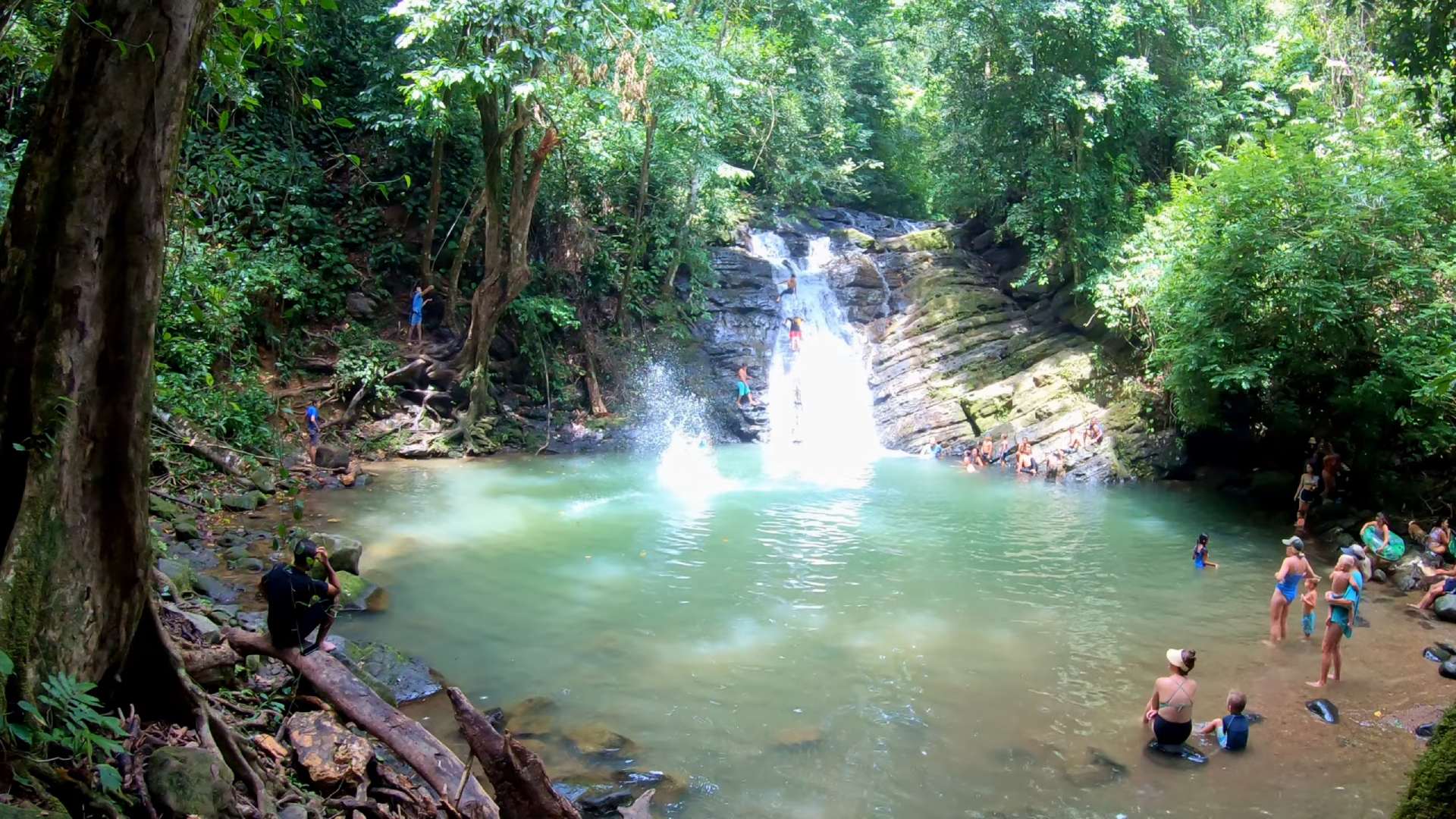
Further along, the road passes by the entrance to Nauyaca Waterfall, one of the region’s most impressive natural attractions. A 4km hike (or horseback ride) leads to twin cascades with a natural swimming pool—well worth the detour if you have half a day to spare. Several tour companies in Dominical offer guided excursions, or you can visit independently for a small entrance fee.
As you approach San Isidro, the landscape opens up into a wide agricultural valley surrounded by mountains on all sides. Small farms and ranches line the roadside, with cattle grazing on impossibly steep hillsides—a testament to the resourcefulness of local farmers who have adapted their agricultural practices to this challenging terrain.
San Isidro de El General
San Isidro de El General is the commercial center of Costa Rica’s Southern Zone. Unlike tourism focused coastal towns, San Isidro is a working city where locals outnumber visitors. This gives you a more authentic experience for Costa Rica. You’ll find stocked markets, local eateries, and a non-touristy atmosphere.
Located at about 700 meters in elevation, it’s in a valley surrounded by mountains, so the climate here is fairly consistant and cooler than the coast. Daytime temperatures typically range from 21-29°C, so it’s comfortable to explore on foot all year round. The central area is organized in a grid pattern, with the main commercial district stretching about 10 blocks in each direction from the central park and church.
The Commercial Hub of the South
San Isidro functions as the primary service center for the entire Southern Zone. Locals from surrounding towns and rural areas come here for everything from banking and medical care to shopping and government services. You’ll find practical resources here too, including supermarkets, hardware stores, automotive services, and regional bus connections.
The downtown area centers around the main park (Parque Central) and the blue church (Iglesia de San Isidro Labrador) that anchors the city. From this central point, you’ll see banks with ATMs, pharmacies, clothing stores, and numerous sodas (small local restaurants). Several major supermarkets, including Maxi Pali and BM, have wider selections than you’ll find in coastal towns. For import selection visit the Luferz Supermarket which is on the main highway at the McDonald’s intersection.
If you need to resupply, repair equipment, or access services, San Isidro has everything you might need during your journey through the Southern Zone. Many people use the city as a base for exploring the region or as a stopover when traveling between the coast and San José. Hotel options range from simple hostels to mid-range business hotels, most with good value compared to tourist areas.
Local Markets and Shopping
The Municipal Market (Mercado Municipal) is San Isidro’s commercial primary commercial destination. This indoor market has dozens of small vendors selling fresh produce, meats, cheeses, spices, and prepared foods. It’s the perfect place to sample local specialties like chorreadas (corn pancakes), fresh fruit smoothies, or regional cheeses. The market runs daily but is busiest in the mornings and on weekends.
Every Thursday & Friday, the city has a farmers market (feria) where regional producers bring their goods directly to consumers. Here you’ll see an impressive variety of tropical fruits, many of which don’t appear in standard supermarkets. This is also an excellent opportunity to purchase local coffee directly from the families who grow it, often at better prices than elsewhere. This market is held in a large covered building near the main highway.
Shopping in San Isidro focuses on practical items rather than souvenirs, though you can find some artisanal products at the Mercado Municipal and various shops near the central park. Farther along the stretch of Highway #2, you’ll find more spread out shopping options like Walmart, CoopeAgri and some indoor malls.
Day Trips from San Isidro
San Isidro’s central location makes it an ideal base for exploring nearby attractions. To the west, the mountain route to Dominical leads to waterfall hikes, wildlife viewing, and beach access. Nauyaca Waterfall is about 40 minutes from the city.
Heading east takes you to Chirripó National Park, home to Costa Rica’s highest peak at 3,820 meters. For adventure seekers, the area has white water rafting options from family friendly Class II-III rapids to more challenging Class IV sections.
Several coffee farms around San Isidro allow you to learn about growing and processing Costa Rica’s famous coffee beans, providing insight into the agricultural foundation of the region’s economy.
I use these versatile trail runners on my hikes in Costa Rica. The aggressive grip tackles steep terrain while maintaining comfort for long days on mountain paths.
Buenos Aires: Off the Tourist Trail
I drove into Buenos Aires after passing miles of pineapple fields, and immediately noticed how different it felt from coastal tourist towns. This agricultural hub is about 4 hours south of San José and 45 minutes south of San Isidro. You won’t find many international tourists here. Instead, the central park fills with local families in the evenings, small sodas serve cheap casados, and Spanish dominates both conversation and signage.
The town isn’t fancy – just a simple grid of streets around a central park with a church and municipal buildings. Prices reflect the local economy rather than tourist demand. You can expect to pay lower prices at restaurants, as compared to popular tourist towns like Uvita. The surrounding mountains create a dramatic backdrop, especially in the morning when clouds hang low over the ridges.
Indigenous Culture and History
Buenos Aires borders several indigenous territories, including the Boruca and Térraba reservations. These communities have maintained their cultural practices despite centuries of outside pressure. In the town park, you’ll notice distinctive round stones created by pre-Columbian indigenous peoples – similar stones appear throughout the Southern Zone.
The indigenous lands house natural springs and rivers flowing from the mountains. When I visited a hot springs in the indigenous territory, I met the owner Arnold who manages the property. It had both hot and cold pools fed by natural springs. We picked lemons growing on trees around the property and squeezed them into our drinking water – a simple experience that felt worlds away from commercial tourist attractions.
If you’re here in late December or early January, try to catch the Juego de los Diablitos (Game of the Little Devils) celebration by the Boruca people. Local men wear hand-carved masks representing “devils” (the indigenous people) who battle against a bull (representing Spanish colonizers). After days of ceremony, they burn the bull effigy, symbolizing indigenous resistance.
Hot Springs and Natural Attractions
The mountains around Buenos Aires contain several hot springs from the region’s geothermal activity. These aren’t developed resorts – most are simple pools with minimal facilities. The water temperatures vary between spots, but all offer a rustic bathing experience that costs a fraction of what you’d pay in tourist areas.
From town, you can see the slopes of the Talamanca Mountain Range, part of which forms Parque Internacional La Amistad spanning the Panama border. Rivers flowing down these mountains create small waterfalls and swimming holes throughout the area, many are listed on Google Maps but many aren’t. Exploring the area with a rental car is a great option.
The drive to Buenos Aires passes through extensive pineapple plantations – rows upon rows of spiky plants stretching to the horizon. Around town, small farms raise cattle, sugar cane, and various fruits. It’s amazing to see cattle grazing on hillsides so steep they seem to defy gravity. The farmers have adapted their techniques to this challenging terrain, clearing narrow paths that zigzag up the mountains.
If you want to experience Costa Rica beyond the tourist trail, Buenos Aires has a genuine look at rural life, indigenous heritage, and natural attractions that most visitors never see. It makes a perfect stopover when traveling between the Central Valley and points further south, or as a base for exploring the surrounding mountains.
If these blog posts and videos help plan your Costa Rica vacation, please support our channel.
Follow Us
Keep up with our latest Costa Rica travel videos and guides by subscribing to our YouTube channel. We regularly post new content showing real conditions across different regions and seasons.
Leave a comment with your Costa Rica travel questions – we’re happy to help plan your perfect time to visit.
Frequently Asked Questions
How long should I stay in the Southern Zone?
Plan for at least 4-5 days to properly experience the Southern Zone. This allows time for 1-2 days in Dominical for beach activities and surfing, 1 day for the mountain drive with stops at viewpoints and small towns, 1-2 days based in San Isidro to explore the valley and nearby attractions, and potentially a day trip to Buenos Aires if you’re interested in indigenous culture. You could spend a week or more in this region, using it as a base to explore attractions further south like the Osa Peninsula.
What’s the best time of year to visit the Southern Zone?
The dry season (December through April) has the most reliable weather for exploring the Southern Zone. January and February are ideal months with clear skies, though this is also peak tourist season. The shoulder seasons (May/June and November) can be good compromises, with fewer visitors and intermittent rain that typically falls in the afternoons. During the green season (July through October), morning activities are usually fine, but heavy afternoon rains are common.
Do I need a 4×4 vehicle to explore the Southern Zone?
While a standard vehicle can manage the main roads between Dominical, San Isidro, and Buenos Aires during the dry season, a 4×4 or high clearance vehicle provides more flexibility for exploring side roads and accessing natural attractions. During the rainy season (May-November), a 4×4 is strongly recommended, especially for mountain roads where landslides or washouts may occur. If you’re planning to visit indigenous territories or remote hot springs around Buenos Aires, a 4×4 is essential year-round.
Is the Southern Zone safe for travelers?
The Southern Zone is generally considered safe, with lower crime rates than more touristy destinations. Standard precautions apply: don’t leave valuables visible in parked cars, be cautious with belongings at beaches, and avoid isolated areas after dark. San Isidro and smaller towns have a strong local community presence, and violent crime targeting tourists is rare. The biggest safety concerns in this region tend to be related to road conditions, strong ocean currents in Dominical, and occasional flash flooding during heavy rains.
How does the Southern Zone compare to more popular destinations like Guanacaste?
The Southern Zone has a more authentic Costa Rican experience than heavily developed areas like Guanacaste. You’ll find fewer all-inclusive resorts, international restaurant chains, and organized tours, but more opportunities to interact with locals and experience daily Costa Rican life. Prices tend to be lower, crowds smaller, and natural attractions less commercialized. The beaches are less manicured but often more dramatic, with jungle-covered mountains at the shoreline. The climate is generally wetter than Guanacaste, resulting in more lush vegetation and varied ecosystems.
Can I get by with only English in the Southern Zone?
In tourist areas like Dominical, most businesses that cater to visitors have English-speaking staff. However, as you move inland to San Isidro and especially Buenos Aires, Spanish becomes increasingly important. Basic Spanish phrases for ordering food, asking directions, and handling transportation will significantly enhance your experience. In indigenous territories, some older residents may speak native languages in addition to Spanish.
What are the best food experiences in the Southern Zone?
Don’t miss the opportunity to try a traditional casado (a plate with rice, beans, plantains, salad, and your choice of protein) at local sodas, which have authentic food at reasonable prices. In San Isidro, the Municipal Market houses small food stalls serving regional specialties and fresh tropical fruits you won’t find elsewhere. Coffee lovers should try locally grown beans from the mountains around San Isidro, which have distinct flavor profiles from the better-known Central Valley coffees. Along the coast, fresh seafood features prominently on menus, while inland restaurants tend to focus on beef, chicken, and pork dishes.
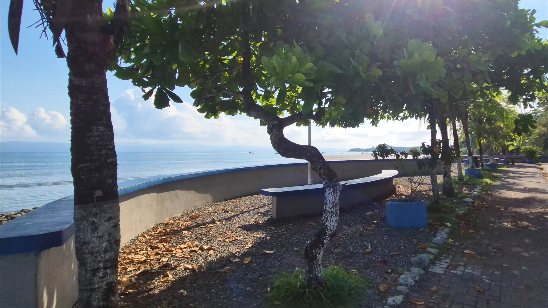
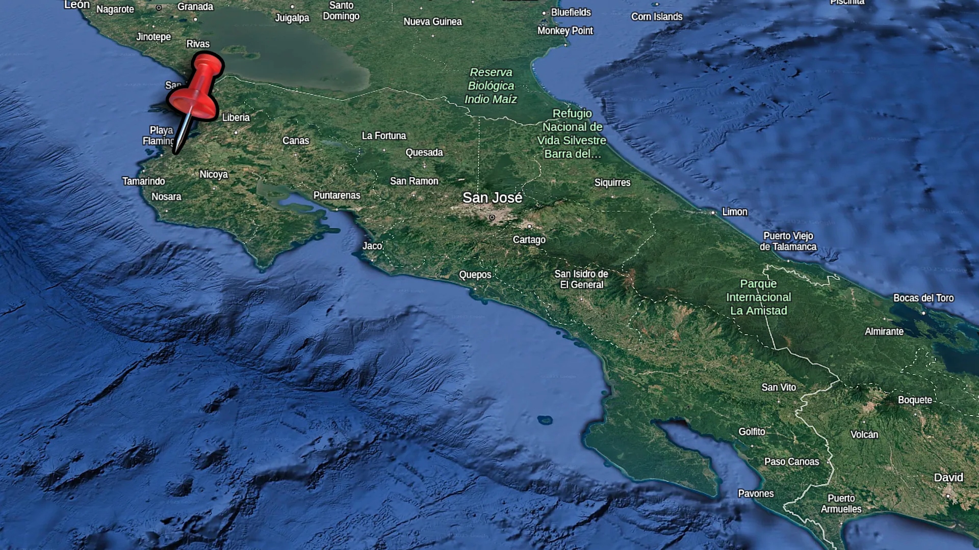
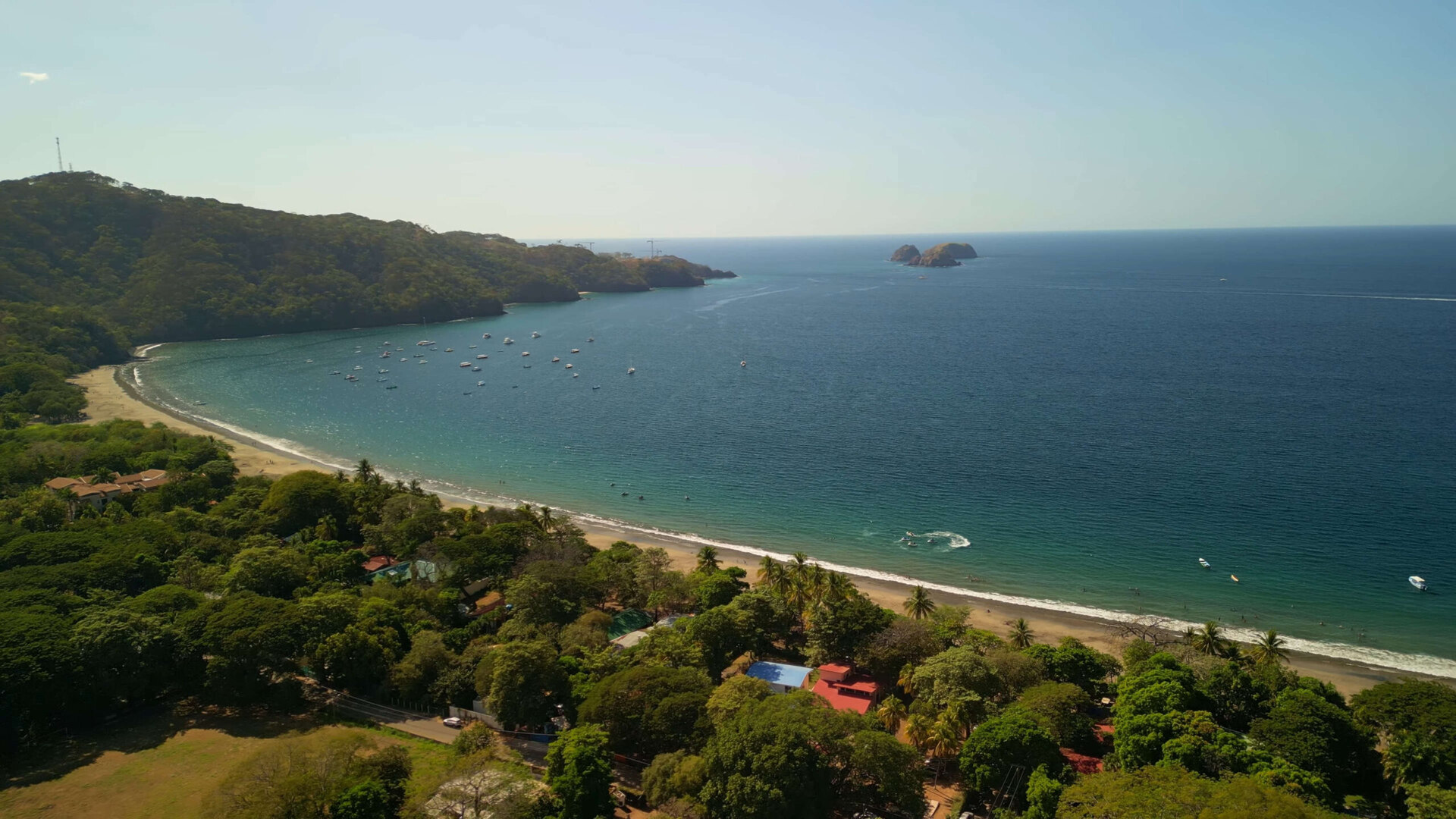
Coco Beach is just 30 minutes from Liberia International Airport, making it the closest beach town to Costa Rica’s northern airport. I’ve been coming to Coco for years and it’s always my first stop when I land in Guanacaste. The town runs along a curved bay with darker sand than some other beaches in the area, but what it lacks in white sand, it makes up for with convenience and variety.
When you arrive in Coco, you’ll notice it’s busier than other beach towns in Guanacaste. The main street away from to the beach and is packed with restaurants, souvenir shops, tour offices, and small supermarkets. I usually park my car and walk around – it’s the best way to get a feel for the town. There’s a reason so many visitors and expats choose Coco as their home base.
If you’re planning a trip to Guanacaste’s Gold Coast, Coco makes a practical starting point. You can stay right in town, explore the surrounding beaches by car, and find everything you need within walking distance. I’ve spent countless days driving through the different neighborhoods, swimming at the beach, and checking out the different food spots. In this guide I’ll share what I’ve learned about getting around, where to stay, and the best spots to check out during your visit.
Travel Tip: You don’t need to buy a SIM card when you land in Costa Rica to get data connection. With an eSIM, you’ll be able to configure your data connection before you depart for your vacation. I use the Saily eSIM in Costa Rica.
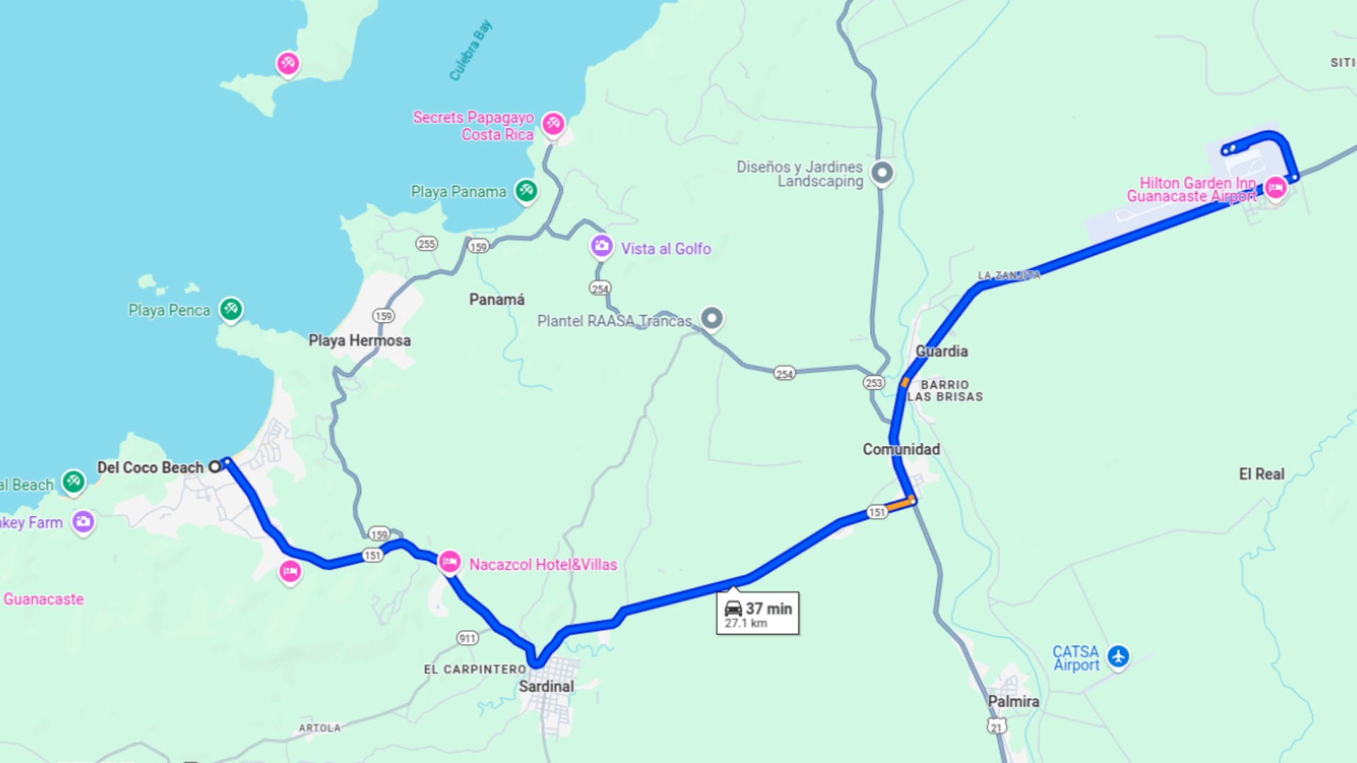
Getting to Playas del Coco is straightforward compared to many Costa Rican beach towns. The drive from Liberia Airport takes about 30 minutes on well-maintained roads. I’ve made this trip dozens of times, and it’s always nice to have such a quick journey from the airport to the beach without any winding mountain roads or river crossings.
The route to Coco takes you through the small town of Comunidad, past Sardinal, and then straight into town. You’ll know you’ve arrived when you head down the hill after the turn to Playa Hermosa. to town. The main road splits – going right takes you toward the north end of beach and Los Palmas area, while right will take you to Playa Ocotal.
Coco is one of the nearest built up beach towns to the Liberia Airport, part of the reason it’s so popular.
From Liberia Airport
From Liberia International Airport, head south on the main highway (#21) until you reach the turnoff for route #159. This junction is easy to spot as it’s well-signed for Playas del Coco. From there, it’s a straight shot west on #159 through Comunidad and Sardinal. The roads are paved the entire way, making it accessible for any type of vehicle, even during rainy season.
If you’re renting a car, all the major agencies like Adobe, Alamo, Enterprise, and National have offices right at the airport. You’ll also find rental agencies in Coco itself, with many located along the main street. It’s typically easier to rent directly from the airport since prices are competitive and they offer shuttles from arrivals.
If you prefer not to drive, you have several alternatives to reach Playas del Coco. Shared shuttle services run regularly from Liberia Airport and cost between $20-30 per person. They may make stops at other hotels along the way. You can book these shuttles in advance online or arrange them through your accommodation.
For the budget friendly option, public buses connect Liberia to Playas del Coco. The bus stop in Coco is located on the main street near the Super Compro supermarket. Buses run several times daily, cost around $2-3, and take about 45 minutes. Keep in mind that if you arrive with lots of luggage, you might want to grab a taxi from the bus stop to your accommodation, as the town is spread out along the beach.
Exploring Coco Beach
Coco Beach stretches in a large curve along the bay, with different vibes depending on which section you visit. The water isn’t as crystal clear as some other Guanacaste beaches, but it’s calm and swimmable most days. I like to walk the entire beach – it takes about 25-30 minutes from one end to the other, and gives you a good feel for the whole area.
The beach has darker sand with some rocky areas, especially at low tide. If you’re looking for pristine white sand beaches, some of the nearby beaches are better options (Playa Bonita, Penca, Calzon de Pobre). Weekends bring families from nearby towns while weekdays are quieter, especially outside the main tourist season.
I recommend bring a pair of water shoes when you visit Playas del Coco. I use mine to walk through town and along the beach.
North End (Los Palmas)
The north end of Coco Beach starts near the area called Los Palmas, which is filled with condos and vacation rentals. This section of beach tends to be less crowded and has several beach access points between the condo developments. I often park near the commercial area with the little supermarket, Java coffee shop, and restaurants like Red Panda and Wave, then walk down to the beach from there.
Swimming is decent at this end, which the water more often being clearer than the central beach. Beach chairs and umbrellas aren’t typically for rent here, so bring your own gear if you plan to spend the day. There are a few restaurants with beach views in this area, but they’re set back a bit from the sand compared to the central beach area.
Main Beach Area
The central section of the beach sits right in front of downtown and is the most developed and busiest part. Here you’ll find the large tree, statues, and a basketball court in the main square right by the water. This area gets crowded, especially on weekends and holidays, with both tourists and locals. The water tends to be a bit murky here but safe for swimming.
Parking can be challenging in this section. There are parking spaces along the main beach road, but they fill up quickly. Sometimes you’ll encounter unofficial parking attendants (watchimen) who’ll ask for money to “watch” your car – usually 1,000-2,000 colones ($2-4). Around this central area, you’ll find plenty of restaurants, bars, and shops just steps from the sand, making it convenient for a day at the beach with all amenities close by.
South End
The south end of Coco Beach is less developed and quieter than the other sections. I’ve noticed fewer people venture down to this end, which makes it good for a peaceful walk or if you want more space to yourself. The water appears murkier here than at the north end, so you’ll be able to fish right from the shore if you’re trying to catch some fish.
You can drive your car down to this section of beach via a dirt road that runs along the shore. This makes it a popular spot for tailgating and barbecues, especially on weekends. New development is happening in this area, with construction of beachfront properties, so the character of this section might change in coming years. This is also the end which has a proposed marina development. There’s a bar that gets lively at times, but overall, this end offers a more laid-back experience than the central beach area.
Where to Stay
Playas del Coco has a wide range of accommodation options from budget friendly studios to luxury condos. The town is spread out along the coastline, with distinct neighborhoods that each have their own character. When choosing where to stay, consider how important beach access is versus proximity to restaurants and nightlife, as well as whether you’ll have a car.
Prices vary significantly by season, with December through April seeing the highest rates. During low season (May-November), you can often find the same accommodations for 30-40% less. Weekly and monthly rentals are common, especially in condo developments, and can offer substantial savings compared to nightly rates.
Los Palmas Area
Los Palmas consists mainly of condo developments with pools and vacation rentals. This area tends to be quieter than downtown but still has convenient beach access via several paths between properties. You’ll find a small commercial center with a supermarket, restaurants, coffee shops, and even a tattoo parlor right in Los Palmas, making it possible to get basics without heading into downtown.
I’ve stayed in several condos in this area and found them to offer good value, especially for longer stays. Many units have rooftop patios with views, and the developments often include shared pools. Los Palmas is about a 15-minute walk to the center of town, making it close enough to access restaurants and nightlife but far enough to avoid noise. This area works well for families and couples who want a bit more space and quiet.
Downtown Options
Staying in downtown Coco puts you right in the middle of the action, with immediate access to restaurants, bars, tour operators, and the central beach area. Accommodation here ranges from simple hotels like La Puerta Del Sol (where the Sunday market is held) to apartments above commercial spaces. The convenience of walking to everything comes with the trade-off of more noise, especially on weekends.
If you choose downtown accommodation, check the exact location carefully. Some places advertise as “downtown” but might be a 10-15 minute walk from the central area. For first-time visitors without a car, staying central makes exploring easy. Street parking can be limited during high season, so ask about parking options if you’ll have a vehicle. I’ve found that downtown works best for shorter stays or for those who prioritize nightlife and restaurant access over tranquility.
Pacifico and Luxury Developments
For those seeking higher end accommodation, Pacifico is the most well-known luxury development in the area. Located a short drive from the beach, it features upscale condos, large houses, and extensive amenities including pools and common areas. The commercial center attached to Pacifico includes the Auto Mercado supermarket (more expensive but with imported goods), plus restaurants like Fab and coffee shops.
Beyond Pacificico, other upscale options include Coco Bay Estates, with nice houses and good views. These luxury developments generally require having a car, as they’re set back from the beach and main town areas. They offer more space, privacy, and amenities, but at significantly higher prices. If you’re looking at these options, expect to pay premium rates, especially during high season when some places can run $200+ per night.
The main beach strip in Playas del Coco has a new pier you can check out for some nice photos, especially at sunset.
Sunday Market
The Sunday Market at La Puerta Del Sol is a weekly tradition in Playas del Coco. Running from morning until about 2:00 PM, this small market brings together local vendors selling everything from fresh fish to handmade crafts. I try to visit whenever I’m in town on a Sunday, and it’s usually busier in the morning than in the afternoon.
The market is located at La Puerta Del Sol, which also functions as a hotel with a well maintained courtyard. You’ll find it just a few minutes’ walk from the beach on the road leading toward downtown. If you’re driving, there’s parking available in the vicinity, though spaces fill up quickly during peak hours.
What to Expect
The Coco Sunday Market is smaller than markets in towns like Tamarindo, but it has a good variety of products in a compact space. Vendors set up booths throughout the courtyard, creating narrow walkways that can get crowded during peak hours. The atmosphere is relaxed and friendly, with vendors happy to chat about their products and often willing to bargain a bit, especially later in the day.
Beyond shopping, the market is a social hub where locals and visitors mingle. The Garden Bar at the venue serves food and drinks, making it easy to spend a leisurely morning browsing and then relaxing with a snack or coffee. If you’re planning to visit, I’d recommend allowing about an hour to walk through the entire market at a comfortable pace, more if you want to stop for refreshments or chat with vendors.
Local Products
The range of products at the Sunday Market is impressive for its size. Fresh food vendors sell locally caught fish (often with pictures to help you identify different species), Italian sausages, and baked goods. There are several booths with kombucha, fruit wines, and specialty food items like garlic oils, hot sauces, and spicy honey that you can sample before buying.
Artisans sell handcrafted jewelry including volcanic stone and Guanacaste wood bracelets, clothing, swimwear, and various arts and crafts. I’ve noticed interesting artwork ranging from paintings to “tropical psychedelic art” and carved wooden items. Prices are generally reasonable, with smaller items like bracelets starting around $10-15 and larger art pieces or clothing items ranging from $25-80. Most vendors accept cash only, so come prepared with colones or small US dollar bills.
Surrounding Beaches
While Playas del Coco serves as a convenient base, some of the best beaches in the area are just a short drive away. I often tell visitors that having a rental car, scooter, or even a golf cart rental (available in town) opens up a whole new dimension to your vacation. Each nearby beach has its own character, water conditions, and crowd levels.
The roads connecting Coco to surrounding beaches are mostly paved and in good condition, though some sections can be rough. During rainy season (May-November), a few routes might have puddles or mud, but they generally remain passable in a standard car. Beach-hopping is one of my favorite activities in this area, and it’s easy to visit multiple spots in a single day.
Playa Ocotal
Playa Ocotal is just a 10-minute drive from Playas del Coco and offers a completely different beach experience. To get there, take the clearly marked turn at the main intersection near Super Compro and follow the paved road. When you reach a Y-intersection, stay left for Ocotal. The road has some curves and it is fairly well maintained, though I wouldn’t want to drive it frequently at night, especially during rainy season.
What makes Ocotal special is its clear water and excellent snorkeling. The beach has black volcanic sand and is smaller than Coco. There are good snorkeling spots at both ends of the beach where you can see colorful fish right from shore. Parking is available at both beach road entrances. During high season, there’s sometimes a parking attendant charging around 1,000 colones ($2).
Other Nearby Beaches
Playa Hermosa is about 15 minutes south of Coco and has a long stretch of gray sand with gentle waves, perfect for swimming. The beach is backed by restaurants and hotels, making it easy to spend a full day there. Further north, about 20 minutes from Coco, you’ll find Playa Panama with its calm waters and fewer crowds – it’s one of my go-to spots when Coco feels too busy.
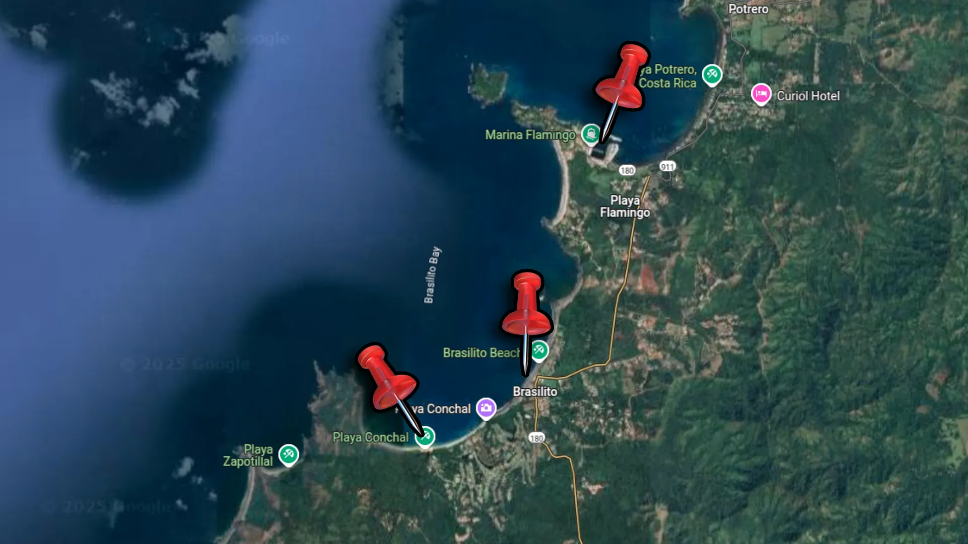
For the adventurous, Playa Gringo is a hidden beach near Ocotal that requires a bit of hiking to access. The entrance path has changed over time, and when I last visited, the original road was blocked off. You’ll need to ask locally for the current access point. Another option worth the 30 minute drive is Playa Flamingo which has light sand and calm waves. Each of these beaches offers something unique, from quiet relaxation to water sports opportunities, making them perfect day trips from your Coco home base.
If these blog posts and videos help plan your Costa Rica vacation, please support our channel.
Follow Us
Keep up with our latest Costa Rica travel videos and guides by subscribing to our YouTube channel. We regularly post new content showing real conditions across different regions and seasons.
Planning a trip to Costa Rica? Contact us — we help with itineraries, logistics, and finding the spots most tourists miss.
Frequently Asked Questions
Where can I buy groceries in Playas del Coco?
Playas del Coco has several grocery options. Auto Mercado (in the Pacificico complex) offers the widest selection including imported items but at higher prices. For more affordable shopping, try Super Compro near the Ocotal turnoff, Mega Super near Los Palmas, or New China supermarket. There are also small convenience stores throughout town for basics. If you’re staying a while, consider stopping at the Mega Super in Sardinal on your way into town for better prices.
Are there ATMs and banks in Playas del Coco?
Yes, Banco Nacional has a branch with ATMs in downtown Coco near the Mega Super. I’ve used their ATMs many times to withdraw cash with no issues. Several other ATMs are scattered throughout town. Most restaurants and larger stores accept credit cards, but smaller vendors, taxis, and the Sunday Market vendors often require cash. Both colones and US dollars are widely accepted.
Where can I get gas in Playas del Coco?
There’s a gas station right in Playas del Coco near the boat parking area, marked by a red building at the corner. It’s convenient but easy to miss. If you can’t find it, ask for directions to the “gasolinera.” The next closest gas station is in Sardinal, about 10 minutes outside of town on the way back toward Liberia. If you’re renting a golf cart or scooter that can’t leave town, the in-town gas station is your only option.
Is Playas del Coco good for families with children?
Coco is family-friendly with calm waters for swimming, a playground near the central beach area, and accommodation options with pools. The north end (Los Palmas) tends to be quieter and good for families. While the beach isn’t the most scenic in the region, kids often enjoy the small tide pools that form at low tide. There are many casual restaurants with kid-friendly menu options, and the easy access from Liberia Airport minimizes travel stress.
Where can I buy fresh fish in Playas del Coco?
There are two good options for fresh fish. One market is on the road to Ocotal (Los Canales), where you can often see fishermen bringing in their catch. They primarily take cash. Another option is near Ocotal with more frozen options. The Sunday Market also usually has a fish vendor with fresh local catch. If you see fishermen coming in at the south end of the beach, you might be able to buy directly from them, though this isn’t as organized as the markets.
When is the best time to visit Playas del Coco?
The dry season (December-April) offers sunny days and minimal rain, but comes with higher prices and more crowds. I personally prefer late November and early May – you’ll get mostly good weather, lower prices, and fewer people. September and October see the most rainfall and some businesses close temporarily. Weekends are busier year-round as locals visit from nearby cities. For the quietest experience, visit mid-week during shoulder seasons.
Is there a pharmacy in Playas del Coco?
Yes, there are several pharmacies in Playas del Coco, with the main ones located along the central street in the downtown area. These pharmacies carry basic medications, sunscreen, and other essentials. Some medications that require prescriptions in the US and Canada can be purchased over-the-counter here. For more specialized medications or medical issues, there are larger pharmacies and clinics in Liberia, about 30 minutes away.
What’s the best way to get around Playas del Coco without a car?
Within Coco itself, walking is feasible for most areas, though the town is spread out along the coast. For longer distances, taxis are readily available and reasonably priced for short trips. Golf cart rentals are popular and perfect for exploring Coco and nearby Ocotal – they cost around $50-70 per day. Scooter rentals are another option at about $30-40 daily. For trips to further beaches like Flamingo or Tamarindo, consider day tours or private shuttles if you don’t have a car.
I’ve been to Manuel Antonio a few times, and it never gets old. This small stretch of Costa Rica’s Pacific coast somehow fits nice beaches, jungle covered hills, and one of the country’s most popular national parks into just a few miles. Whether you’re into boat/fishing tours at Quepos Marina, sunset views at Parque Nahomi, or spotting monkeys in the national park, it’s all right here.
The drive from San Jose airport takes about 3 hours. You’ll head west through the mountains, pass through Jaco, and continue south along the coast until you hit Quepos. From there, it’s just another 15 minutes up the winding road to the Manuel Antonio area. A rental car will be the best option to have, but many hotels offer shuttle services if you don’t want to drive.
What I love most about this area is how different each beach feels. Biesanz Beach is hidden and calm – perfect for swimming. Espadilla is bigger with more action and parasailing. Then there’s the national park beaches that feel totally untouched. You can literally go from having coffee at a marina cafe to watching sloths in the wild in under 30 minutes. Trust me, even if you only have a couple days, you can see a ton here without feeling rushed.
I recommend bring a pair of water shoes when you visit Manuel Antonio. These shoes keep your feet off the hot sand and they dry fast after a jump in the ocean.
Most international travelers land at San Jose’s Juan Santamaría Airport. From there, you’re looking at about a 3-hour drive to Quepos. The route takes you west on Highway 27, a toll road with good pavement. After about an hour, you’ll reach Orotina where the highway splits – take Highway 34 south toward Jaco.
The drive along the coast is pretty straightforward. You’ll pass through Jaco (a good halfway point to stop for food), then continue south through Parrita. Road signs for Quepos are clear, and Google Maps works well in this area. The final stretch brings you right into downtown Quepos, where you’ll find gas stations if you need to fill up.
Driving from San Jose to Quepos is straightforward. Head to the Pacific Coast and then south along the well paved roads.
From San Jose Airport to Quepos
If driving isn’t your thing, direct shuttle services run from the airport to Quepos/Manuel Antonio for about $60 per person. These shuttles are comfortable, though they might make stops to pick up other people along the way. The drivers usually know the area well and can point out interesting sights during the journey.
There’s also a public bus from San Jose’s Tracopa Terminal that takes around 3.5 hours and costs under $10, though you’ll need to get from the airport to the bus terminal first. The buses are surprisingly comfortable with air conditioning, and they run several times daily. Just be prepared for limited bathroom breaks during the trip.
For the quickest option, look into a direct flight from San Jose to the Quepos Airport which is just outside of town. The most popular airline for this route is Sansa. You can visit their website to check for ticket prices and schedule.
Getting Around the Area
Once you’re in the Quepos/Manuel Antonio area, getting around is easy. From downtown Quepos to the entrance of Manuel Antonio National Park is only about 10 kilometers, but there’s a lot packed into that stretch.
The public bus between Quepos and Manuel Antonio runs every 30 minutes (every 15 minutes in high season) and costs about $1. It’s a great option if you don’t want to deal with parking, which can be difficult near the national park entrance. I’ve taken this bus multiple times and it’s usually filled with a mix of locals and tourists.
If you have a rental car, the main road between Quepos and Manuel Antonio is well-paved but winding. Parking at beaches and the marina is usually available for a small fee (around $4-6 for the day), often with unofficial parking attendants watching your car. Just make sure not to leave valuables visible inside your vehicle, as you would anywhere.
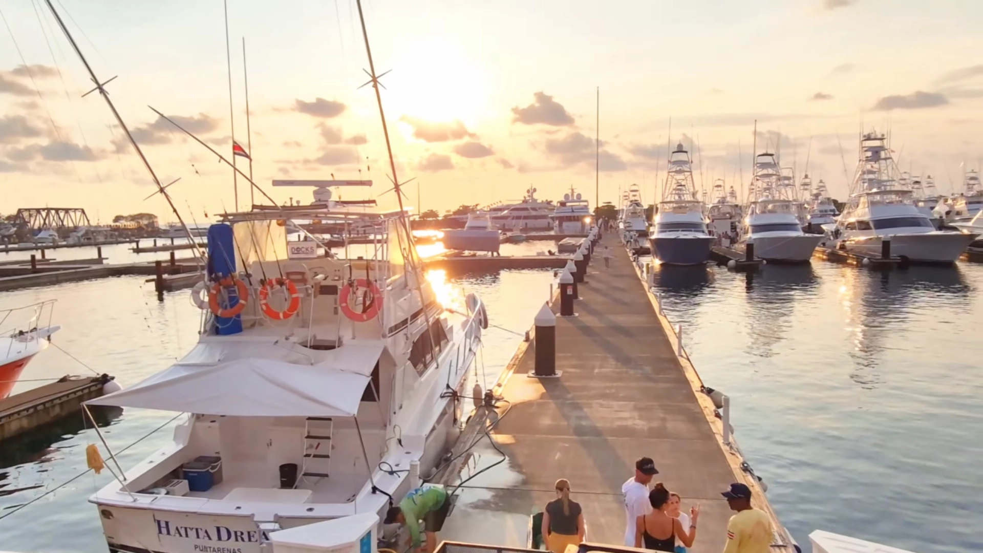
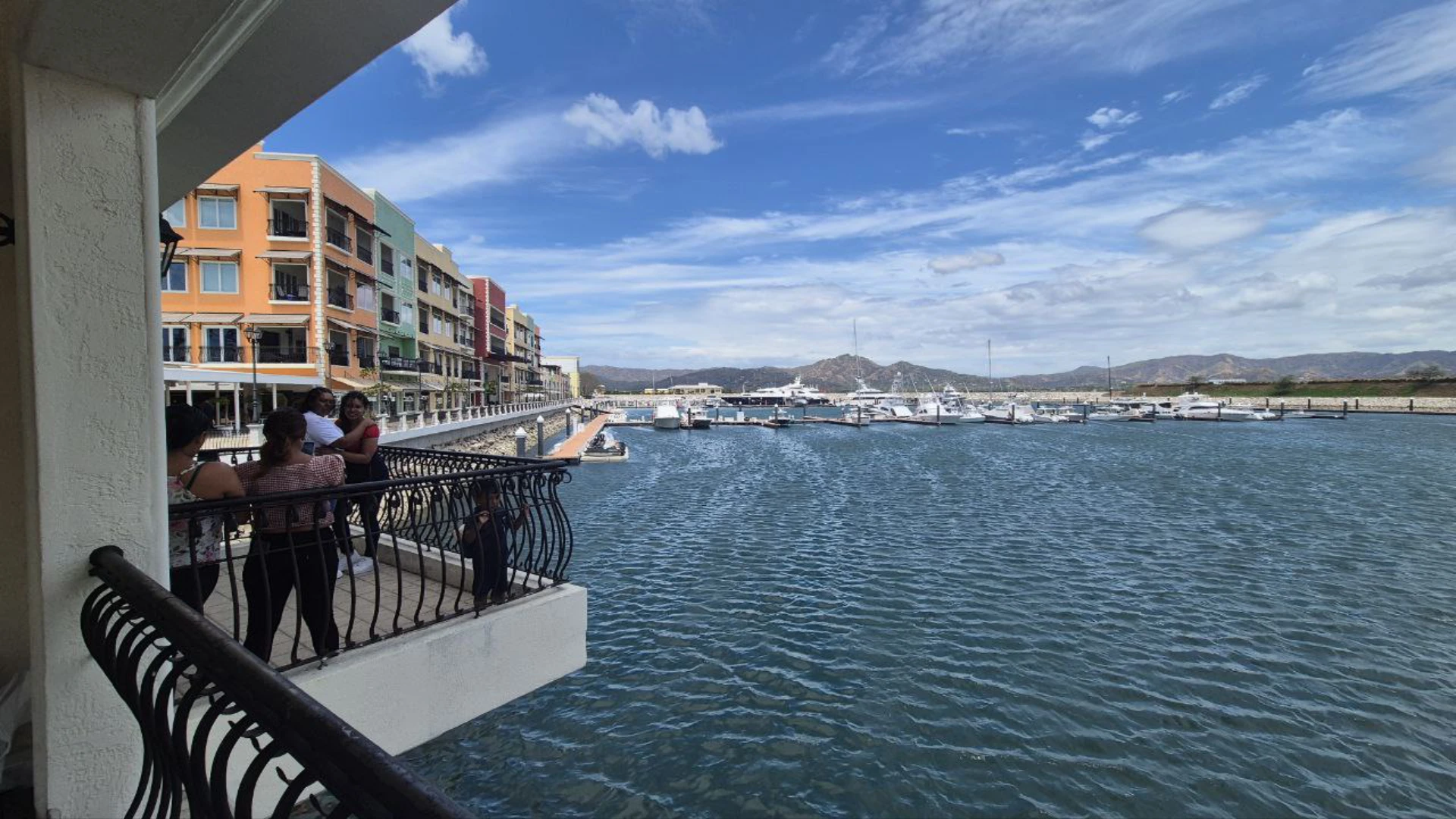
Quepos Marina “Pela Vez”
The Quepos Marina, officially called Marina Pez Vela, is right at the edge of town and makes for a perfect stop in the area. It’s more than just a place for boats – it’s a modern complex with shopping, restaurants, and activities. The marina also has a hospital within it should you find the need.
What surprised me most about this marina is how clean and well-designed it is. The walkways give you great views of the boats, from small fishing vessels to massive luxury yachts. If you’re lucky, you might catch a fishing tournament happening – they host several major competitions throughout the year.
Shops and Restaurants
The marina has a nice collection of shops selling everything from beach gear to high-end clothing. There’s a coffee shop with gelato that makes for a perfect cool-down spot after walking around in the heat. You’ll also find a beauty salon and several souvenir shops if you’re looking to take something home.
Food options range from casual cafes to multi-story restaurants with ocean views. The restaurants are built on different levels, so even from the second or third floor, you can enjoy panoramic views of the water while eating. Prices are higher than in downtown Quepos, but the setting makes it worthwhile for at least one meal during your stay.
For cigar enthusiasts, there’s a shop selling Costa Rican cigars made with tobacco from Nicaragua and Cuba. The cigars start around $7, with premium options available if you’re looking to splurge. The main cigar shop is actually just up the road from the marina if you want a wider selection.
Boats and Activities
The star attractions at Marina Pez Vela are the boats themselves. Walking along the docks, you’ll likely see some enormous luxury yachts. If you’re into fishing, this is the place to book a charter – Costa Rica is famous for its sportfishing, and the waters off Quepos are particularly good for sailfish and marlin.
Even if you’re not fishing, you can book boat tours directly from the marina. Options include sunset cruises, whale watching (seasonal), and trips to nearby islands or snorkeling spots. Prices vary widely depending on the type of boat and duration, but expect to pay at least $50-100 per person for most excursions.
If you’re just visiting, the marina itself is free to walk around and makes for a pleasant hour or two of exploring. The best time to visit is late afternoon when you can watch the fishing boats return with their catch, then stay for dinner as the sun sets over the water.
Sunset at the marina in Quepos. This is where you’ll catch your fishing charter or rent a yacht to enjoy the ocean.
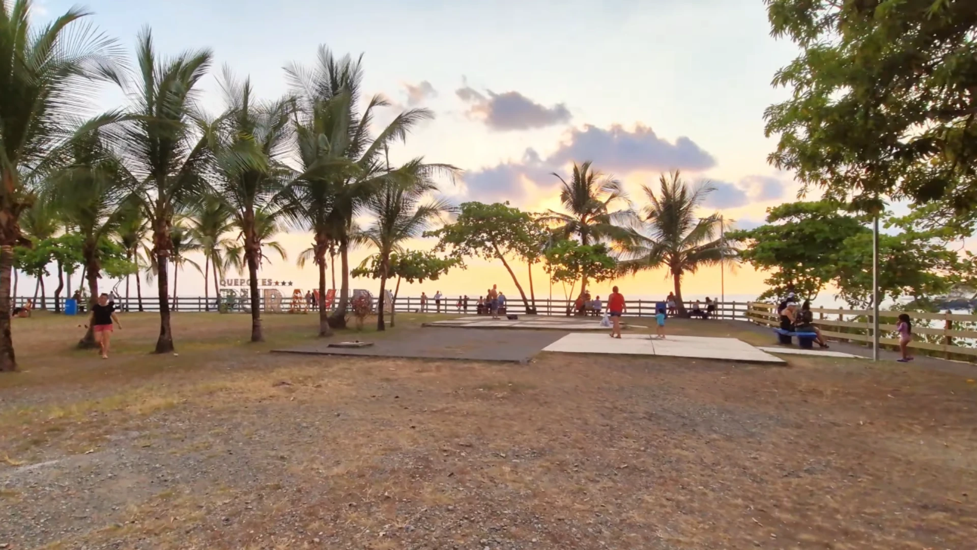
Parque Nahomi
Parque Nahomi is just a short drive or walk from Marina Pez Vela, it’s an easy next stop on your tour through the area. This small park sits on a point overlooking the bay and is known for having some of the best sunset views around Quepos. It’s free to enter and has plenty of palm trees providing shade throughout the day.
The park is split into two distinct areas – the main park area with grassy spaces and palm trees, and a swimming area down below. Even if you just have 30 minutes to spare, it’s worth stopping by, especially in the late afternoon when the lighting is perfect for photos of the coastline.
Parque Nahomi is a large park just outside of Quepos. It’s a wide open area with fences around, allowing for great views.
Swimming Area and Water Activities
Below the main park area is a small but pleasant swimming spot. Unlike the bigger beaches in the area, this spot features calm, protected waters that are perfect for families with small children. The water here is typically much calmer than at the more exposed beaches.
From the swimming area, you can rent kayaks and stand-up paddleboards. It’s an ideal launching point since the bay is protected from large waves. I’ve seen paddle board tours departing from here, with groups heading out to explore the coastline from the water. Prices typically run around $20-30 for a one-hour rental or $40-50 for guided tours.
If you’re not swimming, you can still walk down to this area for different views of the bay and to watch boats coming and going. There’s something peaceful about this little cove that feels separate from the busier parts of Quepos and Manuel Antonio.
The sheltered cove behind Parque Nahomi is great for swimming, snorkeling and paddleboarding. The waves are much gentler as they break on the other side of the park.
Sunset Views
The main draw of Parque Nahomi is undoubtedly the sunset views. The park sits on an elevated position with clear sightlines across the bay. As the sun goes down, you’ll see it sink behind the peninsula across the water, creating stunning silhouettes of the surrounding hills and boats in the harbor.
There are plenty of space for sunset viewing, and you can simply bring blankets and have picnics on the grass. I’ve visited multiple times, and even during busy periods, the park never feels too crowded. If you’re into photography, arrive about an hour before sunset to claim a good spot and watch how the lighting changes.
The Hills of Manuel Antonio
The road between Quepos and Manuel Antonio twists through steep, jungle-covered hills. This 10 kilometer stretch packs in most of the area’s hotels and restaurants, with signs for everything from $30 hostels to $500-a-night luxury spots along both sides of the road. I’ve stayed up in these hills a few times, and while the roads are steep, the payoff is those Pacific Ocean views.
If you stay in these hills you’ll be right in the midst of wildlife. You’ll hear howler monkeys before you see them – their deep, rumbling calls echo through the hills especially in early morning. White-faced monkeys are bolder, and during one stay they actually came right up to my balcony. There’s something surreal about watching these monkeys swing through trees just feet away from your accommodations.
Resorts and Accommodations
Most hotels here are built into the hillsides, using terraced designs that step down the slopes. Tulemar Resort is one of the most well known, with its private beach access and bungalows throughout 33 acres of jungle. Los Altos Resort has spacious apartment style accommodations with full kitchens and massive balconies facing the ocean. Makanda by the Sea is adults only with more private, intimate villas and one of the most Instagram worthy infinity pools in the area.
What I like about staying in the hills rather than down in Quepos is the temperature difference. You catch better breezes up here, and many rooms face west for those sunset ocean views. Most places include breakfast, which typically means fresh fruit, eggs, and gallo pinto (rice and beans). After a day at the beach, it’s nice to come back to a hotel pool for a cold drink and watch the sun go down.
Biesanz Beach is between Manuel Antonio Park and Quepos. It’s a hidden spot with a short hike to get to, but totally worth the visit.
Biesanz Beach (Playa Biesanz)
Biesanz Beach is my favorite spot in the area. Unlike the bigger beaches, this small cove stays calm even when the surf is up elsewhere. The water is clear enough to see fish swimming around your feet. Even on a Sunday when I visited it wasn’t overly crowded.
Finding it is tricky. Look for a gap in the fence near Hotel Parador, about halfway between Quepos and Manuel Antonio park. There’s usually a guy watching cars by the road – they have signs asking for $4 to watch your car. The path down takes about 5 minutes and though it’s not particularly steep, it is uneven with exposed roots and rocks. You might want to wear decent shoes instead of flip-flops.
The beach itself is perfect for swimming – no big waves, no strong currents. A few locals rent chairs and umbrellas for around $5, and sometimes there’s a guy selling fresh coconuts and ceviche. While relaxing on the beach, I saw scarlet macaws flying overhead. You’ll hear them sqauwking, keep and eye out for their bright red feathers standing out against the blue sky. Their squawking calls are unmistakable once you’ve heard them. Morning is best if you want it quiet. By afternoon, more people find their way down. Bring cash, water, and snacks since there aren’t proper stores nearby.
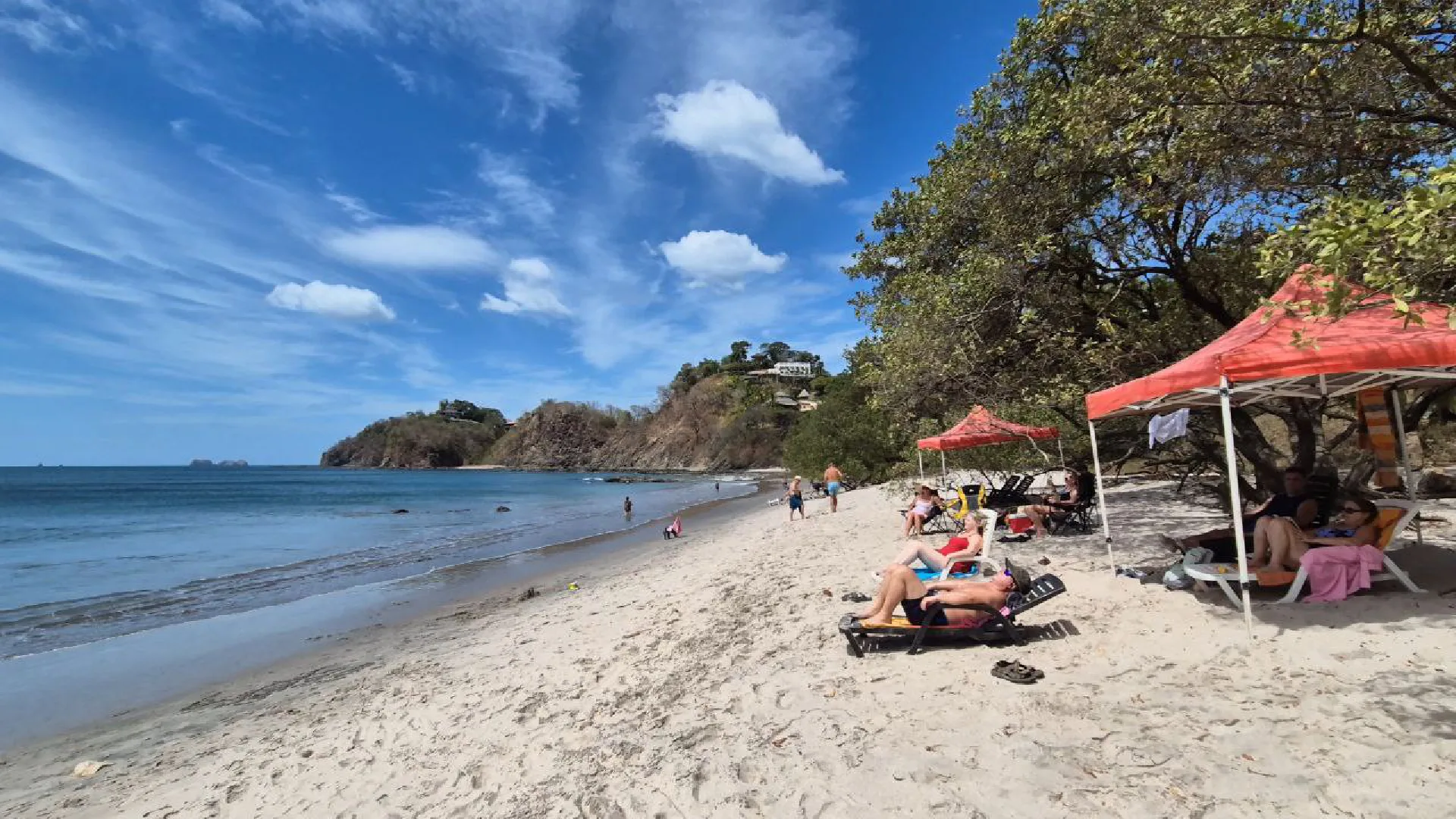
Espadilla Beach
As you approach Manuel Antonio National Park, you’ll come to Espadilla Beach (Playa Espadilla), the main public beach in the area. This wide, very nice stretch of sand runs for about 1.6 kilometers and is divided into Espadilla Norte (North) and Espadilla Sur (South). The national park entrance near the southern end. The waves here are bigger than at Biesanz – good enough for surfing but still okay for swimming if you’re careful.
When I visited, even though it was high season, the beach is long enough that it didn’t feel packed. The northern part has more going on – restaurants, rentals, vendors walking by. As you walk south toward the park, things quiet down a bit. The whole beach has this amazing backdrop of green hills that makes you remember you’re in Costa Rica, not just any beach.
Playa Espadilla on a Sunday. Even though it’s busy you can see there’s still a lot of space on the beach to relax and rent a chair/umbrella.
Parasailing and Water Sports
If you’re into water activities, this is the place. From the beach, you can watch parasailers going up and down. They hook you to a parachute, then a boat pulls you along the coast. It costs around $60-75 for a 15-minute ride.
You can also rent surfboards here. It’s about $10-15 per hour or $25-30 for the whole day. The waves aren’t huge, so it’s actually pretty good for learning. Jet ski rentals are available too, though they’re pricier and sometimes get restricted depending on conditions or season. Most water sport vendors cluster at the north end of the beach, and you can just walk up and book on the spot. No need to reserve ahead unless it’s Christmas or Easter week when things get really busy.
Food and Amenities
One thing I like about Espadilla compared to the smaller beaches is having actual restaurants right there. You can rent beach chairs and umbrellas (usually around $10 for the day), and people walk by selling coconuts, cold drinks, and snacks.
There are bathrooms along the beach, though you’ll pay about 500 colones (roughly $1) to use them. Most places have outdoor showers to rinse off the salt and sand. If you forgot sunscreen or need a beach toy, there are small shops at the north end, but you’ll pay about twice what you would in Quepos. I learned that lesson with a $20 bottle of sunscreen on my first visit. I recommend bringing your own sunscreen to save money, like this sunstick available on Amazon.
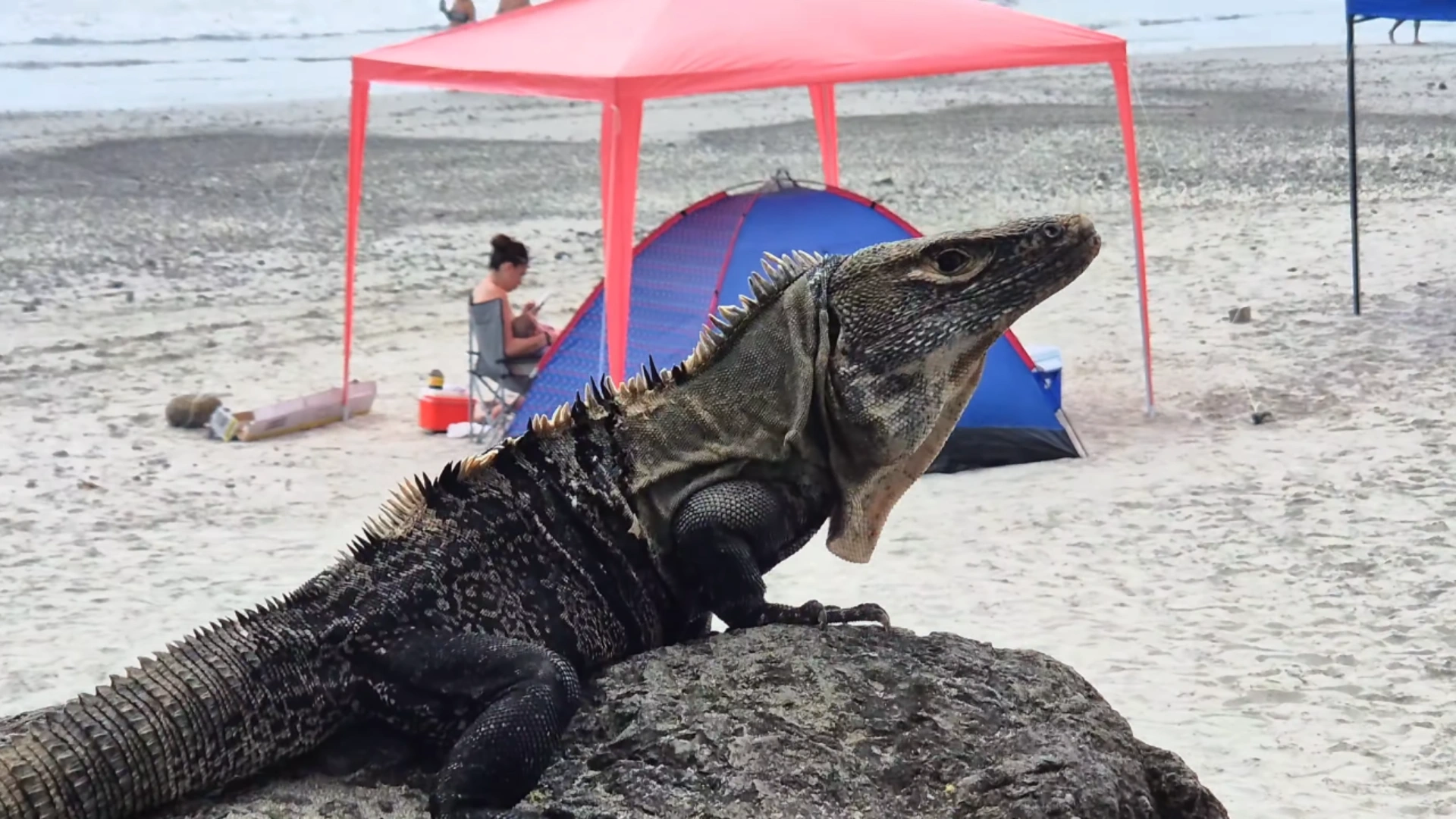
Good boy! This lizard was sunbathing at the beach, and understood the modeling assignment!
Manuel Antonio National Park
Manuel Antonio might be Costa Rica’s smallest national park, but what it lacks in size it makes up for in wildlife. I’ve been here twice now, and I’m still amazed at how many animals you can spot in just a few hours. The park is at the end of the road, just past Espadilla Beach, and has a $18 entrance fee for foreigners. It’s closed Mondays, so plan around that.
My tip? Get there by 7:30 AM when they open. The park limits daily visitors, and in high season, tickets sell out by mid-morning. Buy them at the official booth across from the entrance, not from the guys approaching you on the street claiming to work for the park.
Entrance Information
The ticket system can be confusing. You need to buy at the official booth or online through SINAC, then take your receipt to the actual entrance gate. If someone offers to “help” you buy tickets, they’re probably trying to upsell you a tour.
The tours run about $50-60 per person. Pricey, but the guides have these amazing spotting scopes and find wildlife you might otherwise miss. On my first visit I walked the park on my own without a guide. I saw many groups watching far away wildlife with the guides scopes – worth the expense.
The main trail is an easy 1.3 km walk to the first beach. Most of it’s flat and even wheelchair accessible. Bring water in a reusable bottle (no disposable plastics allowed), some snacks, and bug spray.
Wildlife to Spot
The wildlife here is incredible. You can see three types of monkeys, two sloths, raccoons, coatis, iguanas, and dozens of birds – all in about two hours. The capuchin monkeys are little thieves, so watch your stuff. They know how to unzip backs and will take your belongings up into the trees.
Sloths are harder to find without a guide. They look like fuzzy balls high in the trees, barely moving. A good strategy is to look for groups of people staring up at something – that usually means there’s a sloth or monkey spotted.
The howler monkeys sound scary, but they’re actually chill. Their calls carry for miles, especially in the morning. If you hear what sounds like a monster in the jungle, it’s probably just a howler monkey announcing its territory.
The beach inside Manuel Antonio Park is very nice. It’s a hike to get to but much less busy than Playa Espadilla nearby.
Beaches Inside the Park
The beaches inside the park are worth the entrance fee alone. Manuel Antonio Beach is this perfect white crescent with forest on both sides. The water’s usually calm and great for swimming.
Unlike the public beaches, there are no vendors, restaurants, or rental chairs here – just pure beach. There are basic bathrooms and changing rooms, but that’s it. Bring what you need and take everything back out with you.
The park closes at 4 PM, and rangers start clearing the beaches around 3:30. I found mid-morning (after seeing wildlife) to early afternoon was perfect for beach time. Just enough time to swim, dry off, and make the walk back to the entrance.
If these blog posts and videos help plan your Costa Rica vacation, please support our channel.
Follow Us
Keep up with our latest Costa Rica travel videos and guides by subscribing to our YouTube channel. We regularly post new content showing real conditions across different regions and seasons.
Planning a trip to Costa Rica? Contact us — we help with itineraries, logistics, and finding the spots most tourists miss.
Frequently Asked Questions
What’s the best time of year to visit Manuel Antonio?
The best time to visit Manuel Antonio is during the dry season from December to April. You’ll get sunny days perfect for beaches and wildlife viewing. January to March tends to be the busiest (and most expensive). If you don’t mind occasional afternoon showers, May and November are great shoulder months with fewer crowds and lower prices. September and October see the most rainfall, but accommodations offer their deepest discounts then.
Do I need a rental car in Manuel Antonio?
You don’t necessarily need a rental car in Manuel Antonio. The public bus between Quepos and Manuel Antonio runs every 30 minutes (15 minutes in high season) for less than $1 each way. Taxis are readily available for $8-10 per ride. However, a car gives you freedom to explore hidden beaches like Biesanz and nearby attractions at your own pace. If you do rent a car, be prepared for steep, winding roads and limited parking near the national park.
How many days should I spend in Manuel Antonio?
I recommend spending at least 3 days in Manuel Antonio to experience everything without rushing. This gives you one day for the national park, one day to enjoy the beaches outside the park, and one day to explore Quepos Marina and Parque Nahomi. If you want a more relaxed pace or plan to do activities like sportfishing, zip-lining, or mangrove tours, 4-5 days would be ideal.
Is Manuel Antonio safe for tourists?
Manuel Antonio is generally very safe for tourists. The biggest issues are petty theft and natural hazards. Never leave valuables unattended on beaches or in your car. Be careful of rip currents when swimming, especially at Espadilla during high tide. In the national park, don’t feed wildlife and watch for monkeys trying to grab your belongings. Use normal travel precautions, especially at night in Quepos, and you’ll likely have a trouble-free visit.
Do I need a guide for Manuel Antonio National Park?
A guide isn’t required but is highly recommended, especially for first-time visitors. Guides cost around $50-60 per person but they have spotting scopes and trained eyes to find wildlife you’d likely miss on your own – particularly sloths and camouflaged animals. If you’re on a budget, you can explore independently, but consider bringing binoculars and joining other groups when they spot something interesting. I’ve done both guided and self-guided visits, and saw significantly more wildlife with a guide.
What should I pack for Manuel Antonio?
For Manuel Antonio, pack lightweight clothing, swimwear, a rain jacket (even in dry season), hiking shoes or sturdy sandals, water shoes for rocky beaches, sunscreen, insect repellent, and a reusable water bottle (plastic bottles aren’t allowed in the national park). Don’t forget binoculars for wildlife spotting, a waterproof phone case or bag for beach days, and a small backpack for day trips. Most hotels provide beach towels, so you can save that space in your luggage.
Puerto Jimenez is the primary town in Costa Rica’s wild Osa Peninsula, giving adventure lovers a great home base for exploring one of the country’s most wildlife-rich regions. This coastal port connects you to empty beaches, gold panning adventures, and amazing wildlife watching without the tourist crowds you’ll find in more popular spots. Puerto Jimenez feels completely different from the busy capital of San Jose – the pace is slower, the streets are quieter, and you’re right next door to Corcovado National Park.
What I love about Puerto Jimenez is how many different things you can do without traveling far. In the morning, you might see scarlet macaws flying right over the town center. By lunch, you could be panning for gold in a jungle stream. And before sunset, you’ll have time to relax on beaches that are less visited. The town faces the beautiful Golfo Dulce (Sweet Gulf), where you can spot dolphins, paddle a kayak, or swim in surprisingly calm waters. Unlike Tamarindo or Jaco, Puerto Jimenez keeps its local character with family run restaurants, small markets, and fishermen bringing in the day’s catch at the town pier.
Getting to Puerto Jimenez takes some time, which is exactly why it remains so unspoiled. The road from the main highway winds through mountains and farm country before dropping down to the Osa Peninsula, where you should definitely stop at the roadside lookout for amazing views across the entire gulf. This far distance makes Puerto Jimenez perfect for travelers who want to experience the real Costa Rica away from big tour groups and all-inclusive resorts. You’ll still find comfortable places to stay, good food options, and guides who can show you the incredible natural surroundings.
Travel Tip: You don’t need to buy a SIM card when you land in Costa Rica to get data connection. With an eSIM, you’ll be able to configure your data connection before you depart for your vacation.I use the Saily eSIM in Costa Rica.
Getting to Puerto Jimenez takes some effort, but that’s part of what makes this place special. This remote town on the Osa Peninsula can be reached a few different ways depending on your budget, time, and how much you enjoy road trips. The journey itself is pretty incredible regardless of how you choose to travel.
The most direct driving route from the San Jose Airport (SJO) to Puerto Jimenez in the Osa Peninsula.
By Road from San Jose
Driving from San Jose to Puerto Jimenez takes about 6+ hours if you don’t make stops, and covers roughly 400 kilometers. You’ll head south on Highway 27, which eventually becomes Highway 34 (the Costanera) as it runs along the Pacific coast. After you pass Jaco and continue south, you’ll eventually see signs for the Osa Peninsula turnoff.
The final hour from the highway to Puerto Jimenez includes one of the best parts of the trip – an amazing lookout point with views across the entire Golfo Dulce. We spotted toucans in the trees at this viewpoint, and you’ll likely see scarlet macaws flying around too. Surprisingly, the roads are in great shape the whole way, with good pavement extending all the way into Puerto Jimenez itself.
If you’re driving yourself, plan to make a day of it with some stops along the way. Try to leave San Jose by 7 AM to avoid traffic and give yourself time for breaks. You’ll pass through several beach towns where you can grab food, including Jaco and Uvita. Make sure to fill up with gas at Palmar Norte, as stations become scarce after that point.
Ferry Options from Golfito
If you’re planning to visit Golfito, you can combine driving with a boat trip. Many people drive or bus to Golfito (about 6 hours from San Jose), then take the ferry across the gulf to Puerto Jimenez. The boat ride only takes about 30 minutes and costs around $10 per person.
The ferry usually runs several times each day, with morning and afternoon options. Schedules can change though, so it’s good to check ahead of time. The crossing gives you great views of the gulf and mountains, and you might spot dolphins along the way. You can try integrating a trip to Golfito and Puerto Jimenez with rental cars in either location, as the ferry is for passengers only.
Domestic Flights to Puerto Jimenez
The quickest way to get to Puerto Jimenez is by plane. Sansa Airlines flies daily from San Jose International Airport to Puerto Jimenez’s small airstrip. The flight only takes about 50 minutes and gives you amazing views of the countryside, coastline, and peninsula from above.
Tickets usually run between $80-150 one-way depending on when you travel. The small planes have strict baggage limits (usually 30 pounds total), so pack light. Book well in advance, especially during high season (December-April) when flights fill up fast. The nice thing about flying is that the Puerto Jimenez airstrip is within walking distance of town.
For travelers short on time or traveling light, flying saves you a full day of driving. The views from the plane window are incredible and give you a great first look at the vast wilderness you’re about to explore.
Exploring Puerto Jimenez Town
Puerto Jimenez feels totally different from tourist hotspots like Tamarindo or Manuel Antonio. The town runs along the gulf with a few main streets where most of the action happens. What I love about this place is how it’s still a real working town with local businesses, small hotels, and tour companies that serve both the people who live here and visitors like us.
You can easily walk everywhere in town – nothing is more than about 15 minutes away on foot. The gas station at the north end is a good landmark to get your bearings, and the pier area to the east has some beautiful views across the Golfo Dulce. Everyone moves at a slower pace here, and locals are generally friendly to travelers who’ve made the effort to reach this far corner of Costa Rica.
Town Layout & Main Attractions
The town is pretty simple – there’s one main street running parallel to the coast with restaurants, mini-markets, and tour companies lining it. You’ll find BM supermarket and MaxiPali for groceries if you’re staying somewhere with a kitchen. There are a bunch of small local restaurants (sodas) and coffee shops too. Kids play soccer at the field by the elementary school most afternoons.
The town pier is both a working dock and where the ferry to Golfito comes and goes. When the tide goes out, all the boats just sit on the exposed beach waiting for the water to come back – it makes for some cool photos. This spot is especially pretty for sunrise and sunset shots with mountains in the background across the gulf.
There’s a small park in the center of town where people hang out, and you can walk along several paths by the water. The town beach isn’t great for swimming (it’s mostly thin gravel), but it’s a perfect home base for reaching amazing beaches just a short drive away. You’ll also find the basics you need – an ATM, pharmacy, and a small clinic for emergencies.
A nice sitting area at the beach of Puerto JImenez. You can see out across the bay, and at night the lights of Golfito.
Accommodations & Dining Options
You won’t find big resorts in Puerto Jimenez, just small locally-owned places to stay. Cabinas Las Palmas has simple but comfortable rooms near the water. There are fancier options both in town and just outside it if that’s more your style.
If you’re on a tight budget, hostels have dorm beds starting around $15 a night. Mid-range places run about $50-80 for nice rooms, usually with AC (you’ll want it – it gets hot and humid here). Airbnb has some cool options too, including a few with amazing views of the gulf and jungle.
The food scene focuses on fresh seafood and typical Costa Rican dishes. Agua Luna has nice waterfront dining with fish caught the same day. For cheaper meals, look for “sodas” serving traditional casados (plates with rice, beans, meat, and sides) for around $5-7. There are several little bakeries and coffee shops for breakfast and snacks. For such a remote place, the food options are surprisingly good, though most kitchens close up pretty early.
An interesting insect spotted in the Osa Peninsula. This area has lots of biodiversity.
Wildlife Viewing Around Town
The biggest draw with Puerto Jimenez is seeing wildlife right in town without even trying. Scarlet macaws are everywhere – pairs of these incredible red, blue, and yellow birds fly overhead all day long. You’ll probably hear their loud squawking before you actually see them. These aren’t zoo birds – they’re completely wild but have gotten used to living near people.
Early morning and late afternoon are best for spotting macaws when they’re flying around looking for food. They love to eat from the almond trees along the shore and in town. I saw at least six or seven pairs just during a short morning walk through the center. This is honestly one of the easiest places in the country to see these amazing birds without paying park entrance fees.
Besides macaws, you’ll spot tons of other birds around town. Toucans hang out in trees near the mirador lookout point on the road into town. Green parakeets, hummingbirds, and all kinds of tropical birds live in gardens and trees throughout Puerto Jimenez. With ocean, forest, and town all coming together, it creates this perfect environment for wildlife, making even a quick walk to the store feel like a mini nature tour.
Gold Panning in Dos Brazos de Tigre
One of the Osa Peninsula’s most unique activities is gold panning in the rivers near Puerto Jimenez. The area has a long history of gold mining, with small scale prospectors (called “oreros” locally) still working the rivers today. The small community of Dos Brazos de Tigre, about 20-30 minutes from Puerto Jimenez, is the center for this authentic Costa Rican experience that few tourists ever discover.
Gold panning tours offer a fascinating glimpse into both local culture and the natural environment. Unlike commercial tourist activities, these experiences connect you with local guides who have often spent their lives searching for gold in these same rivers. The combination of adventure, cultural exchange, and the thrill of possibly finding gold creates a memorable experience that highlights a different side of Costa Rica beyond the typical tourist trail.
Booking a Gold Prospecting Tour
We found and booked our Prospecting Tour through our Airbnb host. This is probably most reliable way to arrange this experience. Many guesthouse and Airbnb hosts have connections with local guides in Dos Brazos de Tigre who offer these tours. Prices typically range from $40-60 per person for a half-day experience.
You won’t find fancy tour buses here—transportation is often simple, with guides meeting you in Dos Brazos if you have your own vehicle. The road from Puerto Jimenez starts as well-paved but transitions to gravel as you approach the small community. While generally accessible with a standard car during dry season, the roads can become more challenging after heavy rains.
When booking, be prepared for a flexible experience that might not have the polished organization of tours in more developed areas. This authentic quality is part of the charm, but it helps to clarify details like duration, what’s included, and what to bring. Basic Spanish skills can be helpful, though many guides have enough English to communicate the essentials of gold panning techniques.
Gold panning in the river near Puerto Jimenez. A family on a nature tour farther up river stopped by to try it out.
The Gold Panning Experience
The gold panning begins with a short hike to reach the river. The walking portion involves crossing small streams (sometimes multiple times), so water shoes are highly recommended. The trail passes through beautiful forest areas where guides often point out wildlife and plant species along the way.
Upon reaching the river, your guide demonstrates traditional gold panning techniques that have changed little over generations. The process starts with digging material from promising locations in the riverbed, then using a combination of simple tools to separate gold from sand and rocks. The key tool is the “sluice” or “sleuth,” a metal channel with ridges that trap heavier gold particles while allowing lighter materials to wash away.
The gold panning process is hands-on and physical, expect to get wet and muddy as you dig, carry materials, and work in the river. Guides typically help construct small dams and catchment areas to improve gold recovery, explaining how the river flow and geology determine where gold deposits might be found. When tiny gold flakes eventually appear among the black sand at the bottom of your pan, it’s pretty exciting. They might be small, but they’re real gold particles worth a few dollars even in their minimal quantities.
Gold flakes found after running loads of gravel and dirt through the pan. These were extracted with a small bottle.
Wildlife Encounters During the Tour
While gold panning was our main activity, the journey to and from the river is an excellent wildlife viewing opportunity. The Osa Peninsula contains some of Costa Rica’s most intact rainforest, and the rivers attract diverse animal species. During gold panning tours, you may spot wildlife that might otherwise require expensive guided hikes in national parks.
The rivers themselves host numerous species. If you’re observant, you might spot basilisk lizards (commonly called “Jesus Christ lizards” for their ability to run across water) along the riverbanks. The clear waters sometimes reveal freshwater fish, crabs, and crayfish moving among the rocks. Watch out for spiders underneath the river rocks!
The surrounding forest areas support even more biodiversity. Troops of monkeys—including howler, spider, or white-faced capuchins can be seen moving through the canopy above the rivers. Vibrat poison dart frogs can sometimes be spotted near damp areas along the trail. Your guide, having spent years in these forests, can typically identify most species you encounter, adding an impromptu nature tour to the gold panning adventure.
Best Beaches Near Puerto Jimenez
While Puerto Jimenez itself isn’t known for swimming beaches, some of Costa Rica’s most spectacular and uncrowded stretches of sand lie just a short drive away. The area’s beaches offer a different experience than the popular tourist beaches on the Pacific coast – here, you’ll often find yourself completely alone or sharing miles of coastline with just a handful of other visitors. These beaches combine beautiful tropical settings with the wild, untamed character that defines the Osa Peninsula.
Most beaches near Puerto Jimenez lack extensive facilities, preserving their natural beauty and tranquil atmosphere. Pack anything you might need for the day, including water, snacks, and sun protection. The reward for this lack of infrastructure is experiencing pristine coastal environments that feel worlds away from Costa Rica’s more developed beach destinations.
Playa Preciosa and Playa Platanares
Just 2 kilometers south of Puerto Jimenez, Playa Preciosa lives up to its name (“Precious Beach”) with a long stretch of dark sand lined with palm trees and almond trees that provide natural shade. The beach curves gently along the Golfo Dulce, with typically calm waters perfect for swimming. The shallow entry and minimal waves make this beach suitable for families and less confident swimmers.
Continuing north past Playa Preciosa, Playa Platanares runs for several more kilometers, essentially forming one continuous beach system. The transition between the two beaches is barely noticeable, but Platanares tends to be even less crowded. Leatherback and olive ridley sea turtles nest on these beaches between July and December. If you’re visiting during nesting season, be especially respectful of marked nesting areas.
The road to these beaches is generally accessible with a standard vehicle, though some sections can become muddy/sandy. Limited facilities exist along these beaches, with a few small restaurants and lodges scattered along the shore. Matapalo Surf Lodge and Iguana Lodge are landmarks in the area offering food and drinks even for non-guests. Both beaches have beautiful sunrise views across the gulf and excellent walking opportunities along their extensive shorelines.
Playa Preciosa with a view to the southwest. This is at the end of the Osa Peninsula, and has calmer waves with great sandy beaches.
Other Hidden Beaches Worth Exploring
If you’re willing to venture a bit further from Puerto Jimenez, there’s a few even further options. Playa Colibri, reached by a somewhat challenging road requiring a 4×4 vehicle during rainy season, is a pristine beach that rarely sees tourists. The difficult access ensures solitude and unspoiled beauty.
On the Pacific side of the peninsula, Playa Carate has is a black sand beach where the rainforest meets the ocean. Located about a 45-minute drive from Puerto Jimenez, this remote beach is near an entrance to Corcovado National Park. Strong currents make swimming challenging at times, but the wild beauty and diversity of wildlife make it worth the visit.
For a truly special experience, consider hiring a boat in Puerto Jimenez to reach some of the isolated beaches along Golfo Dulce that have no road access. These hidden coves and have the ultimate private beach experience, sometimes with special features like natural palm tree arches or unusual rock formations. Local boat operators can recommend spots based on your interests, whether that’s snorkeling, wildlife viewing, or simply finding the most secluded stretch of paradise.
Practical Travel Tips
The remote nature of Puerto Jimenez requires some additional planning compared to Costa Rica’s more accessible destinations. With proper preparation, your visit to this unique corner of the Osa Peninsula will be smooth and enjoyable, allowing you to focus on the extraordinary natural experiences rather than logistical challenges.
Weather patterns, transportation options, and available services differ from more developed tourist areas, making advance research especially valuable. These practical considerations will help you maximize your time in this special region while avoiding common pitfalls that can affect travelers to remote destinations.
Best Time to Visit
The Osa Peninsula experiences two distinct seasons: the dry season (December through April) and the rainy season (May through November). Each offers different advantages, affecting both your experience and your budget.
Dry season has consistent sunshine and easier road conditions, making it ideal for beach time and exploring. However, this coincides with Costa Rica’s high tourist season, meaning slightly higher prices for accommodations. Flight prices to Costa Rica also peak during this period, with tickets from major US cities to San Jose typically ranging from $500-800 round-trip compared to $350-500 during green season. From Europe, dry season flights generally start around €700-900 from major hubs like Madrid, London, or Frankfurt, while rainy season can see prices drop to €550-700.
The rainy (or “green”) season offers several advantages despite afternoon showers. The landscape becomes lushly verdant, wildlife viewing can be exceptional as animals concentrate around water sources, and prices drop significantly. September and October see the heaviest rainfall and some businesses close temporarily, but May-August and November offer a good balance of decent weather and lower costs. You may find May and November to be ideal months, with the best combination of reasonable weather, fewer crowds, and lower prices.
There are several flight routes from Europe to San Jose in Costa Rica. When you land, you can drive a rental car, take a shuttle or opt for the fastest route – a regional flight to Osa.
What to Pack
The Osa Peninsula’s hot, humid climate and remote location require thoughtful packing. Lightweight, quick-drying clothing is essential, with long sleeves and pants recommended for dawn/dusk to prevent insect bites. Pack at least one set of clothes that can get thoroughly wet and muddy during activities like gold panning.
For footwear, I’ve found Saucony Excursion TR trail running shoes the best for the Osa Peninsula. They’re lightweight enough for everyday wear but provide necessary traction for muddy trails and river crossings. Unlike heavy hiking boots, they dry quickly after water crossings and don’t become burdensome in the heat. For water activities and gold panning, dedicated water shoes are worth bringing.
A high-quality bug spray containing DEET is non-negotiable in this region. The combination of rainforest and coastal environments creates perfect conditions for mosquitoes and other biting insects. I recommend at least 20% DEET concentration for effective protection, applied regularly, especially around dawn and dusk.
For photography and video, the Samsung Galaxy series phones perform remarkably well in the varied lighting conditions. The videos in this guide were shot entirely on a Samsung Galaxy. The phone’s water resistance gives peace of mind during sudden rain showers or activities near water.
Additional essentials include a good sun hat, reef-safe sunscreen (minimum SPF 30), a reusable water bottle, a small daypack, and a headlamp or flashlight as power outages can occur. Cash is important as ATMs are limited and many smaller businesses don’t accept cards.
Getting Around
Once in Puerto Jimenez, you have several transportation options for exploring the surrounding area. A rental car provides the most flexibility, with several agencies operating in town offering both standard vehicles and 4×4 options. During dry season, most locations around Puerto Jimenez are accessible with standard cars, but rainy season often necessitates 4×4 capability, especially for reaching more remote beaches and the gold panning area.
For those without a vehicle, motorcycle and ATV rentals are popular alternatives, with daily rates significantly lower than car rentals. These options are particularly well-suited to the area’s roads and provide a fun way to explore. Basic models start around $40-50 per day, with more powerful options available at higher prices.
Shuttle services connect Puerto Jimenez with popular destinations in the area, including beaches and trails. These can be arranged through accommodations or tour operators in town. For shorter distances, local taxis operate within Puerto Jimenez and to nearby destinations, with standard rates to common locations.
For exploring the gulf side, consider hiring boats from the main pier. Local captains offer trips to destinations around Golfo Dulce, including otherwise inaccessible beaches and snorkeling spots. These can be arranged directly at the pier or through accommodations, with prices varying based on distance and duration.
If these blog posts and videos help plan your Costa Rica vacation, please support our channel.
Follow Us
Keep up with our latest Costa Rica travel videos and guides by subscribing to our YouTube channel. We regularly post new content showing real conditions across different regions and seasons.
Leave a comment with your Costa Rica travel questions – we’re happy to help plan your perfect time to visit.
Frequently Asked Questions
Is Puerto Jimenez safe for tourists?
Puerto Jimenez is generally safe for tourists, with crime rates lower than in larger Costa Rican cities. As in any destination, take basic precautions like not displaying valuables, being aware of your surroundings, and securing your accommodations at night. The biggest safety concerns are actually environmental – pay attention to currents when swimming, wildlife encounters, and road conditions during rainy season. The community is small and close-knit, which tends to enhance safety for visitors.
How many days should I spend in Puerto Jimenez?
For a satisfying visit to Puerto Jimenez and the surrounding Osa Peninsula, plan to stay at least 3-4 days. This allows time for tours, beach exploration, wildlife viewing in town, and potentially a day trip to Corcovado National Park or a boat excursion. Given the significant travel time to reach Puerto Jimenez (6+ hours from San Jose), shorter visits don’t justify the journey. Many visitors end up extending their stay once they experience the area’s relaxed pace and natural beauty.
Can you keep the gold you find during gold panning tours?
Yes, tourists are typically allowed to keep the small amount of gold they find during guided gold panning tours. The quantity is usually minimal – tiny flakes that might be worth a few dollars at most. Guides often provide small vials to store your gold flakes as souvenirs. However, independent gold prospecting is regulated in Costa Rica, and commercial mining requires permits. The experience and cultural exchange are the real values of these tours, rather than any significant gold discovery.
Are there ATMs in Puerto Jimenez?
Puerto Jimenez has a limited number of ATMs. There’s an ATM at the Banco de Costa Rica branch in town that generally works well. It’s advisable to bring enough cash from larger cities, as many small businesses, tour operators, and restaurants in Puerto Jimenez don’t accept credit cards.
Is it worth visiting Puerto Jimenez during rainy season?
Visiting Puerto Jimenez during the early or late rainy season (May-July and November) can be well worth it. These months offer lush landscapes, fewer tourists, lower prices, and excellent wildlife viewing. The typical pattern brings sunny mornings with afternoon showers, still allowing for plenty of activities. September and October experience the heaviest rainfall and are best avoided unless you don’t mind significant rain. The rainy season also coincides with turtle nesting season on nearby beaches, providing unique wildlife encounters that aren’t possible during dry months.
Do I need a 4×4 vehicle in Puerto Jimenez?
During dry season (December-April), a standard vehicle can access most areas around Puerto Jimenez, including the main road to Playa Preciosa and Platanares. However, a 4×4 is strongly recommended during rainy season (May-November) when roads can become muddy and develop washouts. Regardless of season, a 4×4 is necessary to access more remote locations like Playa Carate or for the gold panning area in Dos Brazos de Tigre. If you’re planning to stick mainly to Puerto Jimenez town and the closest beaches during dry season, a standard car will suffice.
Flamingo, Brasilito, and Conchal are beaches side by side along Guanacaste’s northern coast. These three locations offer different experiences despite being within walking distance of each other. The area sits about an hour’s drive from Liberia International Airport, making it accessible for both short visits and longer stays.
Brasilito gives you the most authentic Costa Rican beach town experience. The central area connects to a gray sand beach where local families gather on weekends. A short drive to the east, Playa Flamingo’s perfect crescent of pinkish white sand attracts more international visitors with its upscale accommodations and marina. To the west of Brasilito, around a small rocky outcrop, you’ll find Playa Conchal. This beach is famous for its unique shore made of crushed shells.
You can easily visit all three beaches in a single day. Most visitors base themselves in either Flamingo or at the Westin Conchal resort, then explore the connecting beaches on foot or by short drives. Each beach has distinct swimming conditions, dining options, and overall atmosphere that we’ll cover throughout this guide.
Travel Tip: You don’t need to buy a SIM card when you land in Costa Rica to get data connection. With an eSIM, you’ll be able to configure your data connection before you depart for your vacation. I use the Saily eSIM in Costa Rica.
The beaches of Flamingo, Brasilito, and Conchal are all located close to each other around a bay in northern Guanacaste. This stretch of coastline is about 20 kilometers north of Tamarindo and 40 kilometers west of Santa Cruz. The area is between the Tamarindo area, and the beaches farther north like Playas del Coco and Playa Hermosa.
The geography creates three distinct beach experiences within a small area. A series of rocky headlands separate these beaches, with Brasilito at the center, Flamingo to the east, and Conchal to the west. The entire area follows Guanacaste’s typical weather patterns with dry conditions from December through April and afternoon showers during the green season of May through November.
Map of Costa Rica showing Playa Flamingo in Guanacaste.
Getting to Brasilito Bay
The nearest international airport is in Liberia. If you’re taking an airport transfer or tour company, they’ll navigate to the beaches. If you’re renting a car, simply drive south from the airport. When you reach the small town of Belen, turn towards the coast. The drive takes about 60-75 minutes on well maintained roads. Signs mark the turnoffs for each beach once you reach the coastal area. Any rental car will make the journey to this area fine, so don’t worry about a 4×4.
If you’re coming from the south, the route from Tamarindo takes about 30-40 minutes. This route is also entirely paved, so you’ll be able to do it in any car – even in the rainy season.
Check our Airports Guide for more details about the Liberia International Airport.
Beach Layout and Connections
Brasilito town is at the center of the bay, with its main road leading directly to its beach. To the north end of Brasilito Beach, you’ll be able to one of the ends of Playa Flamingo. You can walk between these beaches at low tide in about 20 minutes, or drive around in 5 minutes.
Playa Conchal connects to the southern end of Brasilito Beach. A short walk around a rocky outcrop brings you to the shell filled shores. This walking path takes about 10 minutes from central Brasilito. To drive between them, you’ll need to loop around through an inland road that takes about 10 minutes. The drive to the public parking area of Conchal is on unpaved roads, and could require 4×4 in the rainy season. It’s better to park on the paved roads of Brasilito and simply walk to Conchal.
The three beaches form a curved coastline with Flamingo at the norther point, Brasilito in the central bay, and Conchal at the southern edge. You’ll likely find it easy to explore all three in a single day, either by car or by combining walking along the beach with short drives.
Map showing the locations of Playa Conchal (bottom), Brasilito (middle), Playa Flamingo (top).
Brasilito: The Local Experience
Brasilito remains one of the more authentic beach towns in Guanacaste. Unlike its neighbors, Brasilito hasn’t seen major resort development. This keeps its local character intact. The small town centers around Brasilito Park, which in the video below you’ll see was hosting a rodeo and carnival. The park is surrounded by sodas (local restaurants), small hotels, and convenience stores.
The beach runs for about a kilometer with very few rocks, and calm waters for most of the year. On the weekends it’ll be more busy with families setting up under the trees. On weekdays, you might have long stretches of beach nearly to yourself, especially during green season.
Town sign at the center of Brasilito. This is on the main street between Conchal and Flamingo, and only one block from the beach.
Brasilito Beach and Town
Brasilito’s main beach has darker sand than Flamingo and Conchal, but has gentler waves that make it good for swimming. The beach slopes gradually, creating a wide walking area at low tide and calm swimming conditions at high tide. There’s ample shade higher up the beach, which is important to consider as a burn can ruin your vacation. Be sure to bring sunscreen, as it’s expensive in Costa Rica. I like these sun sticks you can pick up on Amazon.
The town itself is compact and walkable. A central plaza is one block with the primary road on one side and the beach on the other. Accommodations in Brasilito tend toward small hotels and cabinas rather than large resorts. Budget options start around $40-60 per night, while mid-range hotels with pools average $80-120. Check on Google Maps for some options just outside of town, but still within walking distance of the beach.
Some photos of the beach at Brasilito, including horses which are used to tour the beach and area.
Activities in Brasilito
Swimming and beach walking are the main activities at Brasilito Beach. The water typically stays calm enough for swimming year round, though afternoon winds can kick up small waves. Local vendors occasionally set up on weekends selling snacks, drinks, and beach items. Most services will be limited as compared to more developed beaches.
Snorkeling is possible around the rocky points at either end of the beach when conditions are calm. The best spot is toward Conchal, where rock formations create habitat for colorful fish. Bring your own gear as rental options in Brasilito are limited. For much better snorkeling you can drive out to Las Catalinas and Playa Danta. I use this snorkel set from Cressi on my snorkeling trips in Costa Rica.
Several tour operators in town arrange fishing trips, sunset sails, and excursions to nearby Palo Verde National Park. These typically cost less than similar tours booked through hotels in Flamingo or Conchal. The town also is a good base for exploring inland attractions like the Llanos de Cortez waterfall, about an hour’s drive away. Here’s a video of Llanos del Cortez, which is a unique waterfall as it has a small beach right at the waterfall pool.
Playa Flamingo
Flamingo is just north of Brasilito on a very nice peninsula with beaches on both sides. This area has become the upscale hub for this part of Guanacaste, with luxury condos, vacation rentals, and higher end restaurants. The main beach forms a perfect crescent between two rocky points. It’s a very photogenic beach and well known for its beauty.
Development in Flamingo focuses on the hillsides overlooking the beach rather than directly on the sand. This keeps the beach itself relatively natural while still offering modern amenities nearby.
The marina at Flamingo has a really nice boardwalk for photos, with the boats and commercial area in the background.
Flamingo Beach
The main beach stretches for about a kilometer between two rocky points. At the north end, a steep hillside creates a dramatic backdrop for the beach. The gently sloping shore makes for excellent swimming conditions most of the year, with calm waters in the morning and small waves in the afternoon.
Flamingo has good facilities compared to Brasilito. You’ll find beach chairs for rent, a couple of restaurants with service right to the sand, and regular beach cleanup that keeps the area pristine. Parking is available on the road that runs parallel along the beach, but it can get busy on weekends.
The swimming here is generally excellent year round. The water gets deep gradually, so it’s great for smaller kids to enjoy. Afternoons can bring wind and choppier conditions, so mornings are best for calm water activities. If you’re trying to save money on food, I recommend bringing some from a grocery store as restaurants in this area can be expensive.
The beach at Flamingo is super clear and clean. It has great views of the Catalinas Islands in the distance.
Flamingo Marina and Surroundings
Just north of the main beach, the Flamingo Marina area is a newer upscale development. The marina is currently being expanded with more services, and there is currently a large commercial development with shops and restaurants. You can also walk along the marina, and see the various boats including the possibility of spotting a mega yacht. From Marina Flamingo you can charter boats and fishing tours. Half-day fishing charters start around $350 for up to 4 people, while sunset sails run $65-95 per person.
The commercial area of Flamingo spreads along the main road with several small shopping centers, restaurants, and tour offices. Prices here run higher than in Brasilito, with meals at nicer restaurants averaging $20+ per person. In the center of the commercial strip, there’s a massive staircase which is very well built. It’s a great spot to take some photos.
The hills around Flamingo offer excellent viewpoints of the entire bay. If you’re staying in the area, try to book accommodation on the hillside for spectacular sunset views. Several vacation rentals have infinity pools overlooking the ocean. For a special splurge, you can book a sunset helicopter tour that flies over all three beaches – the view from above really shows how these beaches connect around the bay.
Playa Conchal
Playa Conchal is one of Costa Rica’s most unique beaches due to its shore made entirely of crushed seashells. Located just west of Brasilito, Conchal has clear turquoise waters and excellent snorkeling conditions. The contrast between the white shell beach and the dark volcanic rocks at either end creates a stunning visual.
This beach has two distinct sections – the eastern area accessible by foot from Brasilito. This end is closer to the frontage of the Westin Resort. The west end is accessible by vehicle with a small parking area. Both offer the same beautiful shell composition, but with different access points and surrounding amenities. Conchal consistently ranks as one of Guanacaste’s most popular talked about destinations.
Map view of Playa Conchal in Guanacaste. You’ll see the Westin Resort and golf course, along with Brasilito in the top right.
Conchal Beach Experience
The shell beach stretches for about 1.5 kilometers with brilliant white crushed shells. The water here is typically clearer than at neighboring beaches, with excellent visibility for snorkeling around the rocky points. The beach slopes more steeply than Brasilito’s, creating deeper swimming conditions closer to shore.
Public access to Conchal comes primarily through Brasilito. Walk to the southern end of Brasilito beach and around the small rocky outcrop to reach the shell sand. This 10-minute walk is easiest at low tide, when you can walk along the wet sand.
The eastern end of Conchal has a few small vendors selling drinks and snacks, particularly on weekends. Bring your own shade, as the beach has limited natural cover except at the edges. The currents here are usually gentle, but afternoon winds can create stronger conditions – always check for flags or ask locals about daily conditions.
Northern Conchal and Villas La Paz
The western section of Conchal offers a quieter experience away from the main beach access points. This area features the same beautiful shell sand but with fewer visitors. Several exclusive vacation rentals and small hotels sit on the hillside overlooking this part of the beach, including Villas La Paz.
Access to northern Conchal requires navigating smaller roads that branch off from the main route. During dry season, most vehicles can make it, but 4×4 is recommended during green season. Alternatively, you can walk north along the beach from the main Conchal access point, which takes about 20 minutes.
The western section offers excellent snorkeling around several rock formations just offshore. The water tends to be calmer here as it’s somewhat protected by the bay’s curvature. Unlike the southern end, this section has very few vendors or facilities, so bring everything you need for your beach day.
The Westin Resort at Conchal
The Westin Reserva Conchal dominates the hillside above the central portion of the beach. This all-inclusive resort spans over 2,000 acres with a golf course, multiple restaurants, and exclusive beach access for guests. The property represents the high end of accommodations in the area, with rooms starting around $300 per night during high season.
Non-guests can access the beach in front of the Westin by walking from either the Brasilito or western access points. While the beach itself is public (as all beaches in Costa Rica), the resort facilities are reserved for guests. The Westin maintains a section of the beach with chairs and service for its guests, but plenty of public beach space remains available.
The resort offers day passes that provide access to some facilities, typically ranging from $50-100 per person depending on the season and what’s included. These passes can be a good option if you want to experience the resort amenities without staying overnight. Reservations are recommended, especially during high season when passes often sell out.
Grand entrance to the Westin Reserva Conchal. This high end resort is popular for tourism as it’s close to the airport and has great nearby beaches.
Follow Us
Keep up with our latest Costa Rica travel videos and guides by subscribing to our YouTube channel. We regularly post new content showing real conditions across different regions and seasons.
Planning a trip to Costa Rica? Contact us — we help with itineraries, logistics, and finding the spots most tourists miss.
Frequently Asked Questions
Here are answers to common questions about visiting Flamingo, Brasilito, and Conchal beaches.
Which of these beaches is best for swimming?
All three beaches offer good swimming, but each has different conditions. Conchal typically has the clearest water and moderate waves, making it excellent for swimming and snorkeling. Brasilito has the gentlest waves, making it good for less confident swimmers and children. Flamingo can have stronger currents on windy days but offers excellent swimming conditions in the mornings.
What’s the best way to get between these beaches?
The easiest way to travel between all three beaches is by car. Flamingo to Brasilito is a 5-minute drive, while Brasilito to Conchal can be accessed by either a 10-minute walk along the beach or a 10-minute drive. If you’re staying at one, you can easily visit all three in a single day. Walking between Brasilito and Conchal is straightforward, but reaching Flamingo on foot from Brasilito requires timing with low tide.
Is Playa Conchal really made of shells?
Yes, Playa Conchal’s shore is composed entirely of millions of crushed and broken seashells that have been smoothed by the ocean over time. This creates a unique white beach that makes a crunching sound when you walk on it. The shells range from tiny fragments to pieces the size of a fingernail.
Do I need a 4×4 vehicle to visit these beaches?
You don’t need a 4×4 to reach the main areas of Flamingo and Brasilito as roads are paved. For Conchal’s western access point, a 4×4 is recommended during green season (May-November) as the dirt roads can get muddy. During dry season, most vehicles can manage the drive to Conchal, but higher clearance is helpful.
Can the public access Playa Conchal if it’s near the Westin resort?
Yes, all beaches in Costa Rica are public by law, including Playa Conchal. The public can access Conchal by walking from Brasilito beach or via the western access road. While the Westin maintains a section with services for its guests, the beach itself remains open to everyone. Just remember that resort facilities like chairs and restaurants are for guests only unless you purchase a day pass.
What’s the best time of year to visit these beaches?
December through April offers the most reliable sunny weather, but also brings the biggest crowds and highest prices. January and February strike a good balance between good weather and manageable crowds. May through August can be a good compromise, with occasional afternoon showers but greener landscapes and fewer people. September and October see the heaviest rainfall and some businesses may close temporarily.
Santa Teresa and Playa Carmen stretch along the southern tip of Costa Rica’s Nicoya Peninsula. A single road connects these beach communities, running about 7 kilometers from the crossroads at Playa Carmen to the northern edge of Santa Teresa. All along this road the jungle meets the sandy beaches of the Pacific coastline.
The Playa Carmen area is essentially at the center point between Santa Teresa to the north and Mal País to the south. This spot is as a tourism hub with its central location and shops, restaurants, and hostels. You’ll find larger grocery stores in this area so you can get your essentials for your stay.
Travel Tip: You don’t need to buy a SIM card when you land in Costa Rica to get data connection. With an eSIM, you’ll be able to configure your data connection before you depart for your vacation. I use the Saily eSIM in Costa Rica.
Santa Teresa is at the southern tip of Costa Rica’s Nicoya Peninsula, about 150 kilometers west of the San José International Airport. Getting here means first driving to the port city of Puntarenas, catching a ferry across the gulf, then winding through the peninsula on a mix of paved and uneven roads. The extra travel time keeps visitor numbers lower than more accessible beach towns.
The Santa Teresa area spreads along a single coastal road that connects several beach communities. Starting at the Playa Carmen intersection, this main dirt road runs north for about 7 kilometers through Santa Teresa before reaching Playa Hermosa. To the south, it connects to the fishing village of Mal País. The entire strip has stayed relatively undeveloped with thick jungle running right up to the beach.
Map of Costa Rica showing the location of Santa Teresa. This town is within Puntarenas Province, and the Province is Guanacaste is to the north.
The Ferry Route from San José
The drive from San José International Airport to the Puntarenas ferry takes about 2 hours. You’ll head west on Highway 1 through the mountains until you reach the long peninsula that is the town of Puntarenas. The ferry terminal is at the far end of Puntarenas, you’ll see the vehicle loading area with large infrastructure for the ferries.
Ferries run several times daily between Puntarenas and Paquera. The first boat leaves Puntarenas at about 5:30 AM and the last one at 8:30 PM. The crossing takes about 70 minutes. You’ll want to arrive at least an hour early to buy tickets and get your car in line. During busy seasons and holidays, showing up an hour early is crucial.
*Note: There is another ferry which goes from Puntarenas to Naranjo. This location is farther north along the Nicoya Peninsula, which will result in a longer drive to Santa Teresa. Be sure to get on the Paquera ferry.
Once you reach Paquera, the drive to Santa Teresa takes about 1.5 hours. The road starts out paved as you head toward Cobano, then turns to uneven pavement/gravel portions for the final stretch to the beach. Most rental cars can handle this route fine in dry season, but 4×4 vehicles make the journey more comfortable.
The Peninsula Drive
From Paquera, you’ll follow the signs toward Cobano on a paved two-lane road. The route winds through hills and farmland for about 45 minutes. Cobano is the last major town before the beach, with several grocery stores and gas stations where you can stock up on supplies.
If you’d like to stop at a beach along the way to Cobano, check out Playa Tambor. This quiet beach is great for swimming and has a few restaurants at the beach. It’s also directly off the main road towards Santa Teresa. Here’s a video profile of Playa Tambor.
Playa Tambor is a sheltered cove beach between the ferry landing and Santa Teresa.
After Cobano, the road is unevenly paved/gravel for the final 25-minute drive to Playa Carmen. This stretch can get bumpy and dusty in dry season or muddy during rains. You’ll pass through the small town of Delicias before the final descent toward the coast. When you arrive at Playa Carmen you’ll see a built up area with grocery stores and shops, along with the ocean one block away.
Most GPS apps work fine for navigation but cell service can get spotty on the final stretch. The route is well marked with signs pointing to Santa Teresa and Mal País at major turns. If you’re arriving after dark, take it slow – the dirt roads have lots of dips and occasional potholes that are hard to spot at night.
Santa Teresa Area
The main road through Santa Teresa runs parallel to the beach, connecting several distinct areas. Starting at Playa Carmen, it heads north for about 7 kilometers to Playa Hermosa. This single dirt road gets busy with ATVs, motorcycles, and cars kicking up dust during dry season.
Playa Carmen marks the start of the strip, with a busy intersection near Super Ronny and the soccer field. As you head north, you’ll pass surf shops, cafes, and hotels tucked into the jungle on both sides of the road. The road stays close to the beach the whole way, with paths leading to different beach access points.
Side roads branch off toward the beach and up into the hills, where many hotels sit on the hillside overlooking the ocean. The main road gets rougher and steeper as you head north, with some sections requiring 4×4 during rainy season. The area has kept its natural feel, with monkeys and iguanas often visible in trees along the road.
Map showing the layout of the Santa Teresa area. Playa Carmen(bottom) is more built up with commercial areas.
Beaches and Areas
The beaches along Santa Teresa stretch for several kilometers, each with its own character. Playa Carmen sits at the center, marked by consistent waves and a busy beach scene. As you move north toward Santa Teresa beach, the sand gets whiter and the crowd spreads out. Further north, Playa Hermosa lives up to its name with clear waters and a quieter vibe.
Small roads lead to hidden beaches on either end of the strip. To the south, Playa Mal País offers rocky tide pools and fishing boats. To the north, beaches like Manzanillo and Majagua take more effort to reach but reward you with nearly empty stretches of sand. The entire coastline faces west, bringing surfers and sunset watchers to the beach every evening.
Playa Carmen Beach
Playa Carmen forms the heart of the area where the main road meets the beach. The wide sand beach has good waves for both beginners and experienced surfers. Several surf schools set up here in the mornings, and you’ll see their students practicing in the whitewash while more experienced surfers head out to the break.
This beach gets busy during mid-day. Surf shops near the beach rent boards and offer lessons. The Super Ronny grocery store sits just back from the sand, making it easy to grab drinks and snacks. Local vendors often set up stands selling fresh coconuts and fruits.
The beach has plenty of shade from almond trees along the sand. The southern end near Mal País has good tide pools for swimming when the surf is big. Most people gather here for sunset, with groups spreading out on the beach or grabbing drinks at the beachfront restaurants.
Santa Teresa Beach
Santa Teresa’s main beach runs north from Playa Carmen for about 3 kilometers. The sand here is whiter than Playa Carmen, and the beach gets wider as you head north. Rocky points break up the beach into smaller sections, each with different waves and swimming conditions.
Several paths lead from the main road to the beach. Signs mark public access points, though some go through hotel properties. The water here breaks harder than at Playa Carmen, drawing more experienced surfers. During low tide, the beach gets wide enough for football games and running.
This stretch has less shade than Playa Carmen but also fewer people. The northern end near Playa Hermosa has some good snorkeling spots around the rocks during calm days. Watch out for strong currents, especially around the rocky points – lifeguards mark dangerous areas with red flags.
Nearby Beaches
North of Santa Teresa, smaller beaches like Manzanillo and Majagua offer a different experience. These beaches take more effort to reach, with rough dirt roads leading through the hills. Manzanillo sits about 15 minutes north by car, while Majagua is another 10 minutes past that. The roads need 4×4 in wet season.
Playa Manzanillo has clear water and good snorkeling around its rocky points. The beach forms a protected bay with gentler waves than Santa Teresa. A small fishing village sits at the south end of the beach, with boats heading out early each morning. The beach has good shade and usually just a handful of people.
Playa Majagua stays almost empty most days. The long beach has white sand and breaks up into small coves at high tide. Getting here means a bumpy drive and a short walk through the forest, but the privacy makes it worth it. There are no facilities at this beach, so bring what you need for the day.
Playa Manzanillo is a perfect sandy beach just north of the area of Santa Teresa.
Where to Stay
Santa Teresa offers lodging options spread along the entire strip, from Mal País through Playa Carmen and up to Playa Hermosa. Most places sit either right on the beach or up in the hills with ocean views. The Playa Carmen area has the highest concentration of hostels and mid-range hotels, making it a good base for first-time visitors.
Prices vary widely across the area. Hostels start around $15 for dorm beds, while mid-range hotels run $50-100 per night. High-end villas in the hills can cost several hundred dollars nightly. Dry season (December-April) sees prices increase by 30-50%, and many places require minimum stays of 3-5 nights during this period.
Playa Carmen Hostels
Playa Carmen has most of the area’s budget options, with over a dozen hostels within walking distance of the beach. These range from simple dorm setups to more social hostels with pools and bars. Most hostels cluster along the main road or on the side streets just off the beach.
El Gato Rojas sits near the Playa Carmen intersection, just a two-minute walk from the beach. The hostel has both shared dorms and private rooms built around a central courtyard with hammocks. The shared kitchen and common areas make it easy to meet other travelers, while the location puts you close to grocery stores and restaurants. I stayed at this hostel and paid about $80 USD for an airconditioned private room.
Other popular hostels include Selina with its coworking space, Lost Boyz with its party atmosphere, and Somos with its yoga deck. Most hostels offer surfboard rentals or discounted lessons through partner schools. During high season, booking at least a week ahead is necessary, especially for private rooms.
Santa Teresa Accommodations
The main Santa Teresa strip offers more mid-range and upscale options. Small hotels with 5-10 rooms make up most of the accommodations here. Many have pools and gardens, with rooms built into the hillside for ocean views. The beach access points are less obvious here, so check the walking distance before booking.
Many places fall into the “rustic luxury” category – think outdoor showers and natural materials but with quality beds and good WiFi. Air conditioning becomes important in this area, as the hills can block the sea breeze. Most hotels include breakfast, often featuring local fruits and Costa Rican coffee.
For longer stays, rental homes and apartments become good options. These often come with kitchens and more space, starting around $700 weekly. Rental agencies in town can help with these bookings, or you can find them through booking sites. Many repeat visitors start in hostels then move to longer-term rentals as they get to know the area.
Some photos of the beach area at Playa Carmen, where local vendors will set up stalls and tables with goods.
Follow Us
Keep up with our latest Costa Rica travel videos and guides by subscribing to our YouTube channel. We regularly post new content showing real conditions across different regions and seasons.
Leave a comment with your Costa Rica travel questions – we’re happy to help plan your perfect time to visit.
Here are answers to common questions about visiting Santa Teresa and Playa Carmen. These will help you plan your trip to this part of the Nicoya Peninsula.
Do you need a 4×4 vehicle to get to Santa Teresa?
A 4×4 is highly recommended for Santa Teresa, especially during green season (May-November). The final 25 kilometers from Cobano to the beach are unpaved with occasional steep sections. In dry season, standard cars can make it but will have a rougher ride. The main road through Santa Teresa is also unpaved with potholes and water crossings after rain.
What is the difference between Playa Carmen and Santa Teresa?
Playa Carmen is the central area where the main road meets the beach, with more businesses, hostels, and a busier atmosphere. Santa Teresa refers to both the entire strip and specifically the area north of Playa Carmen, which becomes progressively quieter as you head north. Playa Carmen has more budget accommodations while Santa Teresa has more upscale options.
How long is the ferry from Puntarenas to Paquera?
The ferry crossing takes approximately 70 minutes each way. Ferries run roughly every 2 hours during daylight, with the first departure from Puntarenas at 5:30 AM and the last at 8:30 PM. During high season (December-April), arrive at least 60 minutes early to secure a spot, especially if traveling with a vehicle.
Is Santa Teresa good for beginner surfers?
Playa Carmen has the best conditions for beginner surfers, with gentler waves and several surf schools. The main Santa Teresa beach has more powerful breaks better suited for intermediate surfers. Morning sessions (6-9 AM) typically have cleaner conditions for learning. Surf lessons cost $40-60 for a two-hour group session including board rental.
How many days should you spend in Santa Teresa?
Most visitors stay 4-7 days in Santa Teresa. The area deserves at least 3 full days due to the effort required to reach it. The laid-back atmosphere and variety of beaches make it easy to extend your stay. Many travelers plan 3 days but end up staying longer. If you’re coming primarily to surf, 5-7 days gives you time to experience different breaks and conditions.
What is the best time of year to visit Santa Teresa?
December through April offers the most reliable weather with sunny days and minimal rain. January and February have the best combination of good weather and manageable crowds. May through November brings afternoon showers but fewer tourists and greener landscapes. September and October see the heaviest rainfall, with some businesses closing temporarily.
Dominical blends surf culture with jungle living where the rainforest meets the Pacific. The small beach town centers around its main dirt road, where local restaurants and surf shops create a laid-back atmosphere away from larger tourist destinations.
Beyond the waves, Dominical offers several natural attractions within minutes of town. Hidden swimming holes like Poza Azul provide fresh water retreats, while less visited beaches like Playa Mozambique stretch north along the coast. Wildlife appears throughout town, from sloths in beach almond trees to toucans flying overhead.
The weekend eco-market showcases local organic products and crafts, highlighting the area’s focus on sustainable living. This mix of surf, nature, and community creates a distinct southern Pacific vibe different from Guanacaste’s beach towns.
Drone photo of Dominical, showing the river to the left and center of town in the middle.
Dominical
Dominical is on Costa Rica’s Pacific Coastal Highway, roughly halfway between Quepos and the Osa Peninsula. This section of coast marks where the mountains begin meeting the ocean more dramatically, creating steep jungle backdrops behind the beach. The town serves as a natural stop between Manuel Antonio National Park to the north and the southern Pacific regions of Costa Rica.
Getting to Dominical
The journey to Dominical takes you along Costa Rica’s Pacific coast, with mostly good condition highways from San Jose International Airport. A convenient option is to drive rental cars, taking Highway 27 west before connecting to the Coastal Highway south. The 3.5-hour route passes through Jaco and Quepos, with plenty of ocean views along the way.
If you prefer not to drive, private shuttle services offer direct transport from the airport. These typically need advance booking are a more comfortable way to travel. Public buses also connect through Quepos, though the journey takes longer with connections.
Where to Stay
Dominical has distinct areas for different experiences. The town center puts you walking distance to surf breaks and restaurants, with accommodations ranging from backpacker hostels to boutique hotels. Whatever option you decide, you’ll find easy access to the beach from in town.
South of town, properties can be found in the jungle. These offer more privacy while staying close to town services. You will be able to expect to see more wildlife close to your door from these areas.
The hillside above town has several hotels and rental homes with incredible ocean views. While these need transport to reach the beach, they provide peaceful settings and a cool breeze. Pools and larger grounds are common at these elevation properties.
Local Food Scene
Dominical’s restaurants center along the main beach road. You’ll find lots of smoothie shops and places to grab a coffee. Keep an eye out for small sodas that provide traditional Costa Rican meals at local prices.
Some international dining options include wood-fired pizza, fusion cafes, and beach bars. Local bakeries and fruit stands add quick options for beach days. There’s enough restaurant options in Dominical that you won’t have to repeat once over a few weeks vacation.
I use this sling backpack when I’m travelling in Costa Rica. It has a zipper lock to secure your stuff. I like the sling as I can flip the bag to the front for easy access.
WEEKLY ECO MARKET
Dominical’s Friday market brings together mountain farmers, local artisans, and food vendors in a vibrant open-air setting. You’ll find it easily by the VW bug van marking the entrance, just off the main road through town.
Some of the options available at the Dominical Eco Market, including honey and oils.
Fresh Local Food
Fresh produce from mountain farms fills the covered walkways, with everything from traditional fruits to organic vegetables. Local farmers bring their food, often freshly picked. You’ll find mangoes, pineapples, and unique mountain-grown items you might not see in regular stores.
Many vendors sell homemade products like honey, coconut oil, and fresh bread. The prices here are local, and the quality is usually better than what you’ll find in supermarkets. Some stands specialize in organic products, while others focus on traditional Costa Rican ingredients.
Artisan Crafts & Natural Products
Local artists are selling handmade jewelry, paintings, and crafts at the market. You’ll find unique pieces that reflect the area’s beach and jungle surroundings. Several vendors offer natural beauty products, essential oils, and handmade soaps.
The market has grown to include more artisans over time, with many creating their goods right in the Dominical area. Look for original artwork, carved items, and textile crafts for great souvenirs you can take home.
Food Court & Refreshments
The food court area has traditional Costa Rican dishes, including casados priced around $8. Fresh smoothies and local coffee are available for a quick refreshment while you browse. Several bakers bring fresh bread and pastries each week.
Most food vendors offer both breakfast and lunch options. You can try traditional dishes or grab something quick like empanadas or fresh fruit. The covered eating area provides a good spot to rest. Nearby the market, there’s a host of dining options available as well.
Pick up a pair of these awesome water shoes. I’ve been using them all over Costa Rica during my travels. They have vented soles so water drains right out the bottom!
WILDLIFE SPOTTING IN DOMINICAL
Along Dominical’s beach, wildlife regularly appears between the beach almond trees and forest edges. The mix of ocean, river mouth, and jungle creates unique spots where you might catch animals during their daily routines.
A sloth spotted navigating the trees at the beach in Dominical.
Sloth Encounters
Two-toed sloths sometimes surprise visitors by appearing right on the beach, moving between the almond trees. While most people expect to find them deep in the jungle, these peaceful animals follow the connected tree line along the shore, looking for fresh leaves.
These beach sightings often happen when sloths need to move between feeding areas. They’ll use several trees in sequence, showing surprising speed as they navigate from branch to branch, always with a clear destination in mind.
Scarlet Macaw Sightings
Pairs of scarlet macaws patrol the coastline daily, their loud calls alerting beachgoers to look up. They follow regular routes between nesting and feeding areas, making them one of Dominical’s most reliable wildlife sightings.
The beach almond trees provide perfect food sources, bringing these colorful birds right to the shoreline. Morning and late afternoon flights offer the best viewing chances.
Common Beach Wildlife
Howler monkeys often wake visitors with their morning calls, moving through the same trees where sloths feed. White-faced capuchins visit in groups, while iguanas sun themselves on fallen logs near the water.
The river mouth attracts fishing birds and basilisk lizards. Early mornings bring the most activity, when animals feel comfortable moving closer to the beach area.
POZA AZUL SWIMMING HOLE
Just minutes from Dominical, this natural swimming hole offers a refreshing escape from the beach heat. The clear river water pools beneath a small waterfall, creating a perfect spot for cooling off. It’s called Poza Azul as the water is often clear blue, but this can change in rainy season with run off from the mountains. Either way, it’s a great place to go for a dip.
Getting There
The entrance is just off the main road going through Dominicalito, marked by a small parking area. A short but steep trail leads down to the river, with a mix of concrete steps and natural tree roots forming the path. The walk takes just a minute or two.
Local parking attendants are usually there to watch vehicles, and there’s no entrance fee to the swimming hole itself. Small shops in the nearby neighborhood have drinks and snacks.
At the Swimming Hole
The main pool stretches wide enough for several groups to enjoy comfortably. A rope swing hangs from a tree branch, and braver visitors jump from the small waterfall rocks. The water stays refreshingly cool year-round.
Deep spots near the waterfall provide swimming areas, while shallower sections offer places to sit and relax. The surrounding trees create natural shade throughout the day.
Safety and Best Times
Morning visits avoid the busiest times, though the spot rarely feels overcrowded. Watch children on the trail down and near deeper water areas. The concrete steps can be slippery when wet, so a walking pole can be helpful if needed.
Bring water shoes for walking on rocks and basic supplies as there are no facilities at the swimming hole itself. Most people will stay 1-2 hours, making it a perfect morning activity before beach time.
Playa Mozambique
A few kilometers north of Dominical, this long stretch of natural beach offers a quiet alternative to the main surf spots. The area connects to a protected zone, with jungle meeting the shore and various trails leading to the sand.
Getting There
Look for the turnoff near the gas station north of Dominical. The road passes Hacienda Baru Lodge before becoming rougher – you’ll need higher clearance to reach the parking area. Several small parking spots exist along the beach access points.
Once parked, walking trails lead through jungle sections before opening onto the wide beach. The shoreline stretches north toward the protected area, with few people even during high season.
Nature Along the Trail
In the video below, we’ll see some leaf cutter ants. These insects create highways across the beach paths, carrying pieces of leaves back to their nests. These fascinating ants maintain clear trails through the forest floor, with some ants carrying leaves while others patrol the paths. Their organized columns can stretch for many meters.
The surrounding trees fill with coconut palms, creating natural shade along the beach. Fallen coconuts scatter the ground, while local harvesters regularly climb for fresh ones. The dense jungle backdrop provides habitat for monkeys and birds.
Beach Experience
The beach offers long stretches for walking, with shallow waters good for swimming at low tide. Waves break further out, creating a gentle slope of sand perfect for relaxing or beach walks. Morning hours bring the calmest conditions.
Unlike busier beaches south near Dominical, this spot rarely sees crowds. The protected area to the north means development stays minimal, preserving the natural beach environment.
Follow Us
I hope you enjoyed this review of the area of Dominical. It’s a great place to spend your vacation in Costa Rica if you’re looking for waves and nature.
Be sure to Subscribe to our Youtube Channel for more great videos for your itinerary.
Dominical Beach Town FAQ: Surf & Nature Guide
Q: How far is Dominical from San Jose Airport? A: 3.5 hours driving. Take Highway 27 to Coastal Highway (34). Pass through Jaco and Quepos. Well-marked roads, several gas stations on route.
Q: What makes Dominical unique? A: Mix of surf culture and jungle access. Weekly eco market. Natural swimming holes nearby. Less developed than northern beach towns. Regular wildlife sightings. Close to whale watching spots.
Q: What day trips are possible? A: Nauyaca Waterfalls (30 min), Uvita Whale Tail (20 min), Poza Azul swimming hole (10 min), Hacienda Baru trails, Hidden beaches like Playa Mozambique. Mountain valley access.
Q: What’s the best season to visit? A: Surf consistent year-round. December-April driest months. Whale watching August-October. Green season (May-November) less crowded. Morning sun common year-round.
Q: What wildlife appears regularly? A: Sloths in beach almond trees, Howler monkeys near river mouth, Scarlet macaws flying over beach, Toucans in morning hours, Whales during migration season.
Q: What services exist? A: Basic beach town amenities: Supermarkets, Medical clinic, ATMs, Surf shops, Tour offices, Variety of restaurants. Weekly farmers market. Surf schools.
Q: What about accommodation? A: Mix of hostels to boutique hotels. Jungle lodges in hills. Beachfront options limited. Most places within walking distance to beach. Book ahead December-March.
Guanacaste, on Costa Rica’s northern Pacific coast, is known for its great swimming beaches. The waves here are usually calmer than in the southern Pacific, making it easier and safer to swim. In this post, we’ll talk about my top 5 favorite beaches in Costa Rica for swimming.
When we look at these beaches, we consider several points. First, we check out the beach itself – things like how soft the sand is, how clear the water is, and if there’s shade from trees. Then we think about how hard it is to reach the beach. Some you can drive right up to, others might need a short hike or a bumpy road trip. We also look at how far each beach is from Daniel Oduber Quirós International Airport in Liberia, since that’s where most visitors fly into.
Lastly, we check what’s near the beach – things like bathrooms, places to eat, and shops. Some beaches have lots of these things nearby, while others are more natural with fewer services. By looking at all these factors, we can give you a good idea of what to expect at each beach.
Before you book your flights to Costa Rica to visit these incredible beaches, visit our Packing List page. I have lots of great stuff that I use during my travels in Costa Rica
Playa Hermosa is an incredible beach in northern Costa Rica. It’s known for its dark sand and calm waters. Many visitors come here to relax, swim, and enjoy the scenery. Playa Hermosa is a short drive away from the very popular town of Playas del Coco.
Playa Hermosa is my favorite beach in all of Costa Rica, as it’s close to the airport, not so busy and always has great water conditions. Here’s some more great reasons to visit Playa Hermosa:
Playa Hermosa is only about a 30 minute drive away from the Liberia International Airport. Being able to depart the airport and arrive at an incredible beach is a huge plus after a day of flying. There’s also two main roads that lead to Hermosa. Should there be some traffic, you can take the back way through Playa Panama. This road is also paved entirely.
Hermosa is very easy to reach. All the roads from the airport to the beach are paved and in great condition. Running parallel along the beach there’s on street parking. I usually park on street at the north end of the road. Some of the hotels and restaurants along the beach also offer parking spots.
Playa Hermosa is usually not too busy. There’s often lots of quiet spots to relax. At some of the beach side destinations like Aquasport and Condovac, it may be a bit busier. On the weekends and holidays you can also expect more people, but it’s rarely packed.
There’s also a couple cool beaches at the north end of Hermosa. One of them, you simply have to walk across the tide pools to reach. It’s a small sandy area with a shallow swimming area. If you venture a bit further, there’s a larger beach which is reachable by jumping in the water and swimming a short distance. I recommend checking this one out at low tide. The name of this beach on Google Maps is Playa Rodilla.
There’s a few restaurants along the beach. Aquasport is very popular as they have a great outdoor dining area, a swing and lounge chairs. There’s also dining options in town – you’ll find a pizza joint and some boutique restaurants like Ginger.
You can also find a few small grocery stores just a short distance from the beach. The bigger grocery store, Luperon, has a pharmacy and gift shop in the same plaza.
You’ll find plenty of options for your stay in Playa Hermosa. The beach is surrounded by mountains which have short term rentals with ocean views. You can also find small, boutique hotels both on and away from the beach. A very popular resort is Condovac, which is at the north end of the beach.
The beach is mostly dark grey sand, so it’s best to bring some water shoes or sandals. The water is most often very clear. You’ll find incredible snorkeling at the north end near the tide pools. You can also rent jetskis, paddleboard and kayaks on the beach. These activities are enjoyable here as the water is often very calm and you’ll get great views of the Papagayo Peninsula.
BEACH #2: PLAYA OCOTAL
Playa Ocotal is my second favorite beach for swimming in Costa Rica. It’s known for dark sand and super clear water. Ocotal is very close to Playas del Coco, just a fwe minutes drive. It’s a good place for those who want to enjoy a beach without big crowds. Ocotal is also renowned for its snorkeling opportunities right from the shore.
Playa Ocotal is about 30 minutes drive from the Liberia International Airport. This makes it a good choice if you don’t want to travel far after your flight. The drive is straightforward, and on paved roads. You can rent a car at the airport or take a taxi or shuttle. If you’re staying in Playas del Coco first, it’s easy to get to Ocotal from there.
Playa Ocotal is easy to get to. It’s about a 5 minute drive from Playas del Coco, which is a very popular beach town. You can take a car or a taxi from Coco. The road is paved and in good shape, so you won’t have trouble getting there. It’s also within walking or cycling distance if you don’t have a car. Once you’re at Ocotal, the beach is right at the end of the road. You don’t need to walk far from where you park to get to the beach. This makes it good for families or people who don’t want to carry their stuff too far.
Parking at Playa Ocotal is easy. There’s a parking area right by the beach where you can leave your car. It’s not a huge lot, but it’s usually enough for the number of people who come to the beach. The parking is free, but there is often an attendant who you can give a few dollars to. On busy days like weekends or holidays, it might fill up faster. If that happens, you can often find street parking nearby. Some of the restaurants and hotels near the beach also let customers use their parking spots. Remember to lock your car and don’t leave valuable things in sight.
Playa Ocotal is usually not very crowded. It’s quieter than nearby Playas del Coco, which is one reason people like it. On weekdays, you might see just a few people on the beach. You can often find a spot to yourself without any trouble. Weekends and holidays are busier, with more locals and tourists coming to enjoy the beach. But even then, it doesn’t get super packed. The beach is big enough that there’s usually space for everyone. Mornings tend to be the quietest time. If you want to avoid crowds, try coming early or during the week. The calm atmosphere makes Ocotal a good place for people who want to relax without lots of noise or activity around them.
Playa Ocotal has some basic amenities to make your beach day comfortable. There is a restaurant called Father Roosers right on the beach where you can get food and drinks. You can usually find fresh seafood, as fishing is popular in the area. You won’t find big shops or lots of vendors on the beach. For more shopping options, you’ll need to go to Playas del Coco. There’s a small convenience store a few minutes walk from the beach for snacks and drinks. Overall, the amenities at Ocotal are simple but enough for a relaxing day at the beach.
There are several places to stay near Playa Ocotal, but not as many as in bigger beach towns. You can find small hotels and vacation rentals close to the beach. Some of these have great views of the ocean. Many places to stay are within walking distance of the beach. If you’re on a budget, you’ll probably find cheaper options in nearby Playas del Coco. From there, it’s easy to visit Ocotal for the day. If you want a quiet place to stay right by the beach, Ocotal is a good choice. But if you’re looking for lots of nightlife and shopping, you might prefer staying in Coco and just visiting Ocotal for the day.
The sand at Playa Ocotal is dark gray or black. This is normal for many beaches in this part of Costa Rica. The sand can get hot in the sun, so you might want to bring sandals or water shoes. The beach slopes gently into the water, so it’s great for relaxing and small kids.
As for the water, it’s usually very clear. On most days, you can see your feet while you’re chest-deep in the water. This clear water makes Ocotal a popular spot for snorkeling. You’ll see fish and other sea life in the tide pools near the beach. At the south end of the beach there’s an alcove which is calm but deeper, making for the opportunity to see needlefish and pufferfish.
The waves at Ocotal are gentle, which makes it good for swimming. Sometimes after heavy rain, the water might be less clear, but this doesn’t last long. The combination of dark sand and clear water gives Playa Ocotal a unique look compared to some other beaches.
BEACH #3: Playa Calzón de Pobre
Playa Calzon de Pobre is a beach in Guanacaste, Costa Rica. It’s not as well-known as some other beaches in the area, but it’s worth checking out if you’re in the region. It’s actually on the Cacique Peninsula which separates Playas del Coco and Playa Hermosa in Guanacaste.
The closest airport to Playa Calzon de Pobre is the Liberia International Airport. It’s about a 1-hour drive from the airport to the beach, depending on traffic and road conditions. The drive takes you through some pretty cool Costa Rican landscapes, with views of dry tropical forests and farmland. If you’re coming from San José, it’s a longer trip – about 4 to 5 hours by car. Many visitors to this area fly into Liberia to save time during their vacation.
Playa Calzon de Pobre wasn’t the easiest beach to reach before, but with the new development at the Waldorf Astoria the road is now paves. Once you get there, you’ll find a small parking area near the beach. It’s not huge, but it’s usually enough since the beach doesn’t get too busy.
One of the nice things about Playa Calzon de Pobre is that it’s usually not very crowded. You won’t find big groups of tourists here like at some of the more popular nearby beaches. It’s more of a local spot, where you might see families having picnics or friends hanging out. The vibe is chill and laid-back. Weekends can get a bit busier, but even then, it’s not packed. If you’re looking for a quiet place to relax by the ocean without a lot of people around, this could be your spot.
Don’t expect a lot of fancy amenities at Playa Calzon de Pobre. It’s a pretty basic beach setup. There are no permanent bathrooms or showers, so plan accordingly. As for food, there aren’t any restaurants right on the beach. Some local vendors sometimes sell snacks or drinks from coolers, but it’s not a sure thing. Your best bet is to bring your own food and drinks. If you want a sit-down meal, you’ll need to drive back towards the main road where there are a few local sodas (small Costa Rican restaurants) serving typical dishes like gallo pinto, casados, and fresh fish.
Accommodation options nearby are limited. There are a few small hotels and vacation rentals in the nearby towns. These places are usually pretty simple but comfortable, offering basic rooms with fans or air conditioning. Some people rent houses or apartments for longer stays, which can be a good option if you want more space and the ability to cook your own meals.
The sand at Playa Calzon de Pobre is a mix of light and dark sand, giving it a unique look. It’s not the super fine, white sand you might find at some other beaches, but it’s nice for walking and laying out your towel. The water is usually very clear. The waves are most often very calm so this is a great beach for swimming and relaxing in the water.
BEACH #4: Playa SAN JUANILLO
Playa San Juanillo is a beach on the Nicoya Peninsula. It’s known for its horseshoe shape and clear waters. It’s roughly between the beaches of Nosara and Tamarindo. The beach itself is incredible, but the drive to it is rough and long. It’s my 4th favorite swimming beach for this reason.
The closest airport to Playa San Juanillo is the Liberia Airport. It’s about a 2-3 hour drive from the airport to the beach. The drive takes you through some nice scenery, with views of the countryside and some small towns. If you’re coming from San José, it’s a longer trip of about 4 to 5 hours by car. If your coming to this area for your vacation, Liberia is the better airport to land at.
You can also get the regional airline called Sansa, they have flights from Liberia to Nosara for about $140. The route between Nosara and San juanillo is only about a 40 minute drive, but it’s more likely to require 4 x 4 as there is a small river crossing and the road is in rough condition.
From the Liberia Airport, you’ll head south along well paved and marked roads. As you pass through Santa Cruz, you’ll start driving towards the coast. Just before you arrive at Playa Junquillas, you’ll turn south and drive on a dirt road for about 1 hour. The road can be bumpy and dusty, especially during the dry season. In the rainy season, it might get muddy. A regular car can make it, but a raised SUV type vehicle is better if you have the choice. There are some signs, but it’s a good idea to use GPS. The beach itself is easy to access once you’re there.
Parking at Playa San Juanillo is easy. There’s a small parking area near the beach where you can leave your car. It’s not a huge lot, but it’s usually enough since the beach doesn’t get very crowded. Playa San Juanillo is much quieter than some of the more popular nearby beaches of Tamarindo and Nosara. You’ll see some tourists, but it’s also popular with locals. Weekends can be busier, especially if it’s a holiday. If you go on a weekday, you might have stretches of the beach almost to yourself. It’s a good spot if you want to relax without lots of people around.
This beach is very laid back, with very few vendors on the beach. It’s a great place to hang out and relax. Given the rough drive to get there, you’ll find it’s no very busy. When I visited, there were a few overland trucks set up for camping. This beach is a perfect location for that, as it’s got great swimming and views.
On the sand bar that separates the two beach areas, there’s a small hill that has a trail. At the top you’ll find a great view of the coast and ocean, along with some flags. It’s a perfect spot to take a photo.
Playa San Juanillo is pretty basic when it comes to amenities. There aren’t any permanent bathrooms or showers on the beach, so plan ahead. For food, there are a couple of small restaurants a short drive from the beach. They’re simple places where you can get typical Costa Rican food. There are some small grocery stores in town, but nothing very big or fancy. Sometimes food trucks park near the beach selling snacks and drinks. However, it’s a good idea to bring your own water and snacks just in case. This beach is perfect for a picnic.
There aren’t any big hotels right on the beach. The accommodation options are more low-key and spread out in the surrounding area. You can find some small hotels, vacation rentals, and bed and breakfasts within a short drive. These places are usually pretty simple but comfortable. Many have nice views of the ocean or the forest. A few examples of local accommodations are Tree Tops Bed And Breakfast, and the Buddha Hotel. If you’re looking for more choices or fancier hotels, you might want to stay in a bigger town like Nosara or Nicoya, and make day trips to San Juanillo.
The sand at Playa San Juanillo is light golden, soft and nice for walking or laying out your towel. The beach forms a horseshoe shape, which makes it very unique for the whole coast. The water on the inside of the horseshoe is calm and clear, it’s great for swimming. You can often see fish swimming around your feet when you’re in the shallows. On the outside of the horseshoe, it’s a bit more rocky and choppy, but still swimmable. However, always be careful and pay attention to any warning signs about ocean conditions.
BEACH #5: PLAYA DANTA
Playa Danta is the beach at the Las Catalinas town in Guanacaste. This beach is known for its calm waters and lots of amenities. The beach is just outside of Playa Potrero, and is often fairly busy due to the attraction of Las Catalinas. It’s my 5th favorite swimmable beach.
It’s about a 1-hour drive from the airport to the beach. The drive is pretty straightforward, the roads are in good condition and it’s an easy trip. If you’re coming from San José, it’s a longer drive – about 4 to 5 hours. The best airport to land at to visit Las Catalinas and Playa Danta is Liberia. You can rent a car at the airport or arrange for a shuttle service.
Once you arrive in the area, you’ll drive through Las Catalinas. If you continue past Catalinas, there is a public parking area which will give you a short hike to the beach. Alternatively, there’s a private parking lot which is paid, but it has security. Both of these lots can be very busy, especially on weekends. If they’re full, you’d need to drive up the dirt roads and find on street parking.
If you decide to start with walking through Las Catalinas, you’ll easily navigate the shopping area to find the beach. There are security guards at Las Catalinas who you can inquire with if you have any questions.
Playa Danta can be very popular. Weekdays are usually quieter. Playa Danita, the beach beside Danta, is the smaller of the two and often less crowded than Danta. If you want a quieter spot, you can walk down to Danita. The busiest times are usually mid-morning to late afternoon. If you go early or late in the day, you might have more space to yourself.
Las Catalinas has a shopping center with restaurants and boutique shops to enjoy. There are bathrooms and showers near the beach. You can also rent beach chairs and umbrellas. You can check out Pura Vida Ride to rent bicycles and explore the trails in the mountains around the beach. Or walk the raised trail through the mangrove towards Playa Danita.
For food, there are a few options right by the beach. Pots & Bowls has healthy breakfast and lunch options. Brew House has drinks which you can enjoy with a ocean view. My favorite is the Ponciana Restaurant at the Santarena Hotel. The decor in this restaurant is incredible, as is the food.
There’s a gym right at the beach called Core by Chakfitness. This unique fitness center has outdoor equipment with plates made of wood. You can also try some back workouts by filling baskets with large rocks for weights. It’s a really great destination for fitness enthusiasts.
There are lots of places to stay near Playa Danta. Being at Las Catalinas, you can find everything from luxury hotels to vacation rentals. Some places have great ocean views. If you want to be right by the beach, there are options within walking distance. The Santarena Hotel is one of the fancier choices. For more space, you can rent apartments or houses in Las Catalinas. These often come with kitchens, which is handy for longer stays. If you’re on a tighter budget, there are some smaller hotels and B&Bs in the nearby areas. Keep in mind that staying right in Las Catalinas can be pricey.
If you’re looking for cheaper options, you might want to stay in nearby Potrero. This small town is actually pretty dense with accommodations options, and is also close to the great beach Playa Flamingo.
The sand at Playa Danta is a mix of light and dark grains. It’s not super fine, but it’s nice for walking and laying out your towel. The beach has a gentle slope into the water, so it’s great for swimming and relaxing. The water is usually clear, especially in the dry season. One of the best things about Danta is how calm the water usually is. The bay is protected, so there aren’t big waves. You can enjoy paddle boarding and kayaking as well. There’s a shop to rent these right at the beach in Las Catalinas.
Follow Us
Keep up with our latest Costa Rica travel videos and guides by subscribing to our YouTube channel. We regularly post new content showing real conditions across different regions and seasons.
Planning a trip to Costa Rica? Contact us — we help with itineraries, logistics, and finding the spots most tourists miss.
If these blog posts and videos help plan your Costa Rica vacation, please support our channel.
FAQ For Traveling In Costa Rica
When is the best time to visit Costa Rica’s beaches?
The dry season, from December to April, is popular for beach visits. The weather is sunny and there’s less rain. But it’s also the busiest time. The green season (May to November) has fewer crowds and lower prices, but expect some rain. Water is generally warmer year-round on the Caribbean side.
Are Costa Rica’s beaches safe for swimming?
Many beaches are safe for swimming, but it depends on the location. Some have strong currents or rip tides. Always check for warning signs and ask locals about conditions. Popular beaches like Manuel Antonio or Tamarindo often have lifeguards. Be extra careful on less developed beaches without safety services.
What’s the difference between Pacific and Caribbean beaches in Costa Rica?
Pacific beaches often have bigger waves, making them good for surfing. The sand is usually darker. Caribbean beaches typically have calmer water and whiter sand. The cultures are different too – the Caribbean side has more Afro-Caribbean influence. Pacific beaches are more developed for tourism.
Can I see wildlife on Costa Rica’s beaches?
Yes, you can often see wildlife on or near beaches. Monkeys and iguanas are common in trees near many beaches. Some beaches are nesting sites for sea turtles – you might see them laying eggs or baby turtles hatching (at the right time of year). Marine life like dolphins or whales can sometimes be spotted from shore.
What should I bring for a day at a Costa Rican beach?
Bring sunscreen, a hat, and sunglasses – the sun is strong. Water and snacks are good to have, especially on less developed beaches. A beach towel or mat, swimwear, and a change of clothes are useful. If you plan to snorkel, bring your own gear. Bug spray can be helpful, especially in the green season.
Are Costa Rica’s beaches crowded?
It depends on the beach and time of year. Popular beaches like Jacó or Tamarindo can get crowded, especially in high season (December to April). Less known beaches are often quieter. Weekends are busier than weekdays. If you want space, try visiting early in the morning or checking out less famous spots.
Can I surf at Costa Rica’s beaches?
Yes, Costa Rica is known for good surfing. Beaches like Tamarindo, Jacó, and Pavones are popular with surfers. There are spots for all levels, from beginners to pros. Many beaches have surf schools and board rentals. The best surfing is usually on the Pacific side, but there are some good Caribbean spots too.
Are there nude beaches in Costa Rica?
Officially, there are no legal nude beaches in Costa Rica. Public nudity is against the law. However, some secluded beaches might have unofficial clothing-optional areas. It’s best to follow local customs and laws to avoid any issues.
How accessible are Costa Rica’s beaches?
Accessibility varies. Some beaches, like those in Manuel Antonio or Tamarindo, are easy to reach by paved roads. Others might require a 4×4 vehicle or even a boat ride. Many popular beaches have facilities for visitors with mobility issues, but less developed ones might be challenging to access.
Can I camp on Costa Rica’s beaches?
Camping directly on beaches is generally not allowed in Costa Rica. However, there are campsites near some beaches. National parks like Manuel Antonio have camping areas close to beaches. Always check local regulations. Some beaches allow camping during turtle nesting seasons for volunteers, but this is organized through conservation groups.
Welcome to Jacó, Costa Rica, a vibrant coastal town along the Pacific that’s gaining popularity for its sun, surf, and adventure. Located about 55 miles southwest of San Jose, Jacó is a popular locations for beach enthusiasts and outdoor seekers. With its easily accessible location, Jacó is a busy town. From great surfing waves to lush hikes through mountain landscapes, Jacó offers a adventure without straying too far from the beaten path.
In this blog post, we’ll show some things to do in and around Jacó. There’s lots of places to stay, nearby beaches and hikes to enjoy. Check out ourShop Page with some necessities for your trip.
The Main Strip
Jacó’s main strip is a very busy road that runs parallel along the beach. You’ll find it to be vibrant and varied, with restaurants serving both Costa Rican and international dishes. There’s plenty of quick/fast food options to fill up during your day at the beach. At night, you’ll find many sit down restaurants with varying price points.
If you need groceries, check out Mas x Menos. This supermarket is owned by Walmart and is essential a mini one. Grab all your essentials for the beach, or to cook dinner. It’s located right downtown.
I suggest carrying local currency while you’re vacationing in Costa Rica. Some street vendors and small shops don’t accept credit card. To pull out cash, I usually go to the national bank called ‘BN’, which is Banco Nacional. They have always been reliable and have very low fees to take cash out of a credit card. The BN in Jacó is on the main strip of the town as well.
While I’m travelling in Costa Rica, I use a secure sling backpack. I like the confidence of being able to lock my stuff in my pack, and the convenience of being able to pull the bag to the front.Check this one out on Amazon.
Pick up a pair of these awesome water shoes. I’ve been using them all over Costa Rica during my travels. They have vented soles so water drains right out the bottom!
Where To Stay
Heading down to the southern stretch of Jacó Beach, you’ll discover a chill spot where the waves are more mellow, making it great for swimming and just soaking. It’s also better for young kids to jump in the ocean. There’s loads of places to stay at this end of the beach. You can find boutique hotels, family friendly developments with pools, and large houses. The south end of the beach is great for relaxing and walking into town for the excitement when you’d like.
If you’re a beginner looking for surfing lessons, the south end of Jacó is likely where you’ll start. The easier, rolling waves are great to learn how to get your footing and positioning on the board. If you have a accommodations in the south end of the beach, you can simply rent a surf board and you can practice as much as you’d like.
The Crocodile Bridge
Just a short drive from Jacó, the Crocodile Bridge in Costa Rica is a fun and free place to stop and see these massive creatures. It’s on the highway from the San Jose Airport, before you arrive in Jacó. This bridge spans the Tarcoles River, which is a larger and murkier river than some others. Along the riverbanks you can spot crocodiles of lengths up to 15 feet. They bask in the sun, creating great opportunities for photos. It’s a unique opportunity to safely witness these cool creatures.
If you decide to stop for a bit longer at the bridge, you’ll find an assortment of dining options. I’ll often grab a locally sourced coffee and the cafe. You can also find a ‘POPS’, which is a ice cream shop that is present throughout all of Costa Rica.
Hike To El Miro
Situated right in Jacó, the El Miro hike is great workout, and a great way to see nature. Along the trail, you will often see animals like scarlet macaws, toucans and even monkeys. Be sure to bring a camera or phone that can zoom in, as they’re often in the dense brush high in the trees.
The trail is long, but not especially steep or difficult in terrain. Be sure to bring water along with you, enough for a couple hours of activity. Kids can easily complete to journey to the lookout at the top, it’ll just take a little longer. Grab a snack a Mas x Menos before heading out with them.
The highlight of the El Miro hike is the chance to explore an abandoned house at the top of the hill. This structure offers a unique vantage point, providing an excellent view of Jacó Beach and the surrounding area. There’s cool graffiti painted all over this abandoned house, some of which is very incredible art.
When I’m doing hikes like this, I prefer to bring hiking running shoes. I find that boots would be too heavy for the simple paths, but I still like some additional grip. Try theseSaucony Trail Runners, available on Amazon.
Relax At Esterillos Oeste
Just a short drive from Jacó to the south you’ll find the beach town of Esterillos Oeste. It’s a laid-back coastal beach with its own unique charm. This beach town is easily accessible, making it a convenient destination for realxation away from Jacó. Esterillos Oeste known for its iconic landmark — the mermaid sculpture off shore in the tidepools. At low tide, you can walk right out to the statue for some great pictures. Tidepools are also great for little ones to swim in and try to spot tiny fish.
If you have a rental car, Esterillos Oeste is a great option to rent a place. This way, you can head into Jacó, or south to Quepos whenever you feel. You’ll be able to relax on a tranquil beach for most of your trip.
Follow Us!
Be sure to Subscribe to our Youtube Channel, and leave a comment with your thoughts about this location or request a video in other cool destinations around Costa Rica.
FAQ For Visiting Jaco
1. Where is Jaco located?
Jaco is located on the Pacific coast of Costa Rica, approximately 55 miles southwest of San Jose, in the Puntarenas province.
2. What is there to do on Jaco’s main strip?
Jaco’s main strip offers a variety of local and international restaurants, shops, and a vibrant atmosphere perfect for exploring Costa Rican culture and cuisine.
3. Where should I stay in Jaco?
Options range from cozy beachfront spots to family-friendly rentals and boutique hotels, especially around the southern stretch of Jaco Beach, which is ideal for a laid-back experience.
4. What surfing opportunities are available in Jaco?
The south end of Jaco Beach is perfect for beginners with its mellow waves, making it an excellent spot for taking surfing lessons and practicing.
5. What can I see at the Crocodile Bridge?
Just a short drive from Jaco, the Crocodile Bridge spans the Tarcoles River, where you can safely view large crocodiles sunbathing along the riverbanks.
6. What is the El Miro hike?
The El Miro hike in Jaco offers a well-marked trail suitable for all skill levels, featuring potential sightings of monkeys and toucans and ending at an abandoned house with panoramic views of Jaco Beach.
7. What is special about Esterillos Oeste?
Esterillos Oeste is a laid-back beach town near Jaco, known for its relaxed vibes and the iconic mermaid sculpture on the shoreline, making it a great spot for a peaceful escape.