Costa Rica’s spectacular waterfalls and cascades. Includes hiking access, swimming holes, and photo opportunities. Features both popular and lesser-known falls.
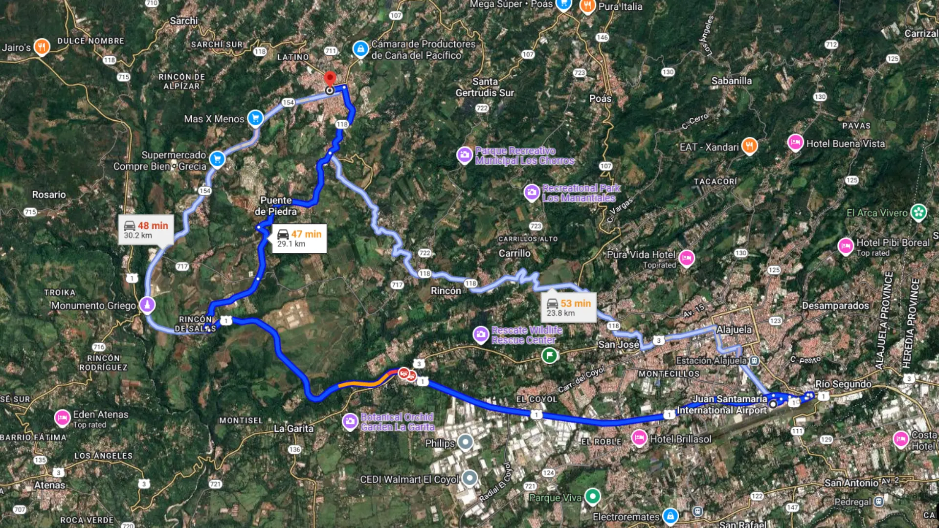
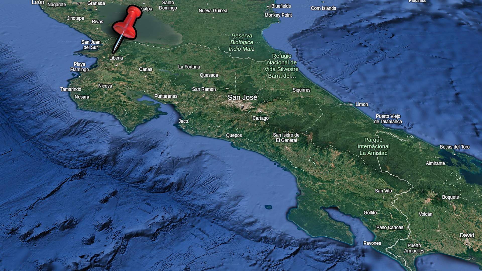
Grecia is located just 30 minutes north of San José’s international airport in Costa Rica’s green Central Valley mountains. This small town provides the perfect overnight stop if you’re heading to La Fortuna or want to avoid driving at night after your flight lands. The cool mountain climate and accessible location make it an easy first or last stop on your Costa Rica trip.
Most travelers rush straight from the airport to beach towns or La Fortuna. They don’t realize what they’re missing in this area. Grecia gives you real Costa Rican mountain life without the tourist crowds. You’ll find farmers markets with local vendors, a genuine town square with an iconic metal church, and a stunning waterfall just minutes away.
This two-day itinerary shows you how to experience Grecia properly. You’ll stay in unique glamping domes with mountain views. You’ll explore both daily and weekly markets. You’ll visit a beautiful waterfall and see the town center. Everything is close together and easy to reach without a 4×4 vehicle.
Grecia makes strategic sense for your Costa Rica travel plans. The town is on the route from San José airport to La Fortuna, one of the most popular tourist destinations in the country. Instead of rushing through a 3-4 hour drive after your international flight, you can stop here for the night and start fresh the next morning.
The location eliminates the stress of night driving on unfamiliar Costa Rican roads. Landing in the afternoon gives you just 30 minutes to reach Grecia. This beats several hours to La Fortuna or the beaches. You’ll also experience a different side of Costa Rica that beach-focused tourists miss.
If you’re heading to La Fortuna for your vacation, check out our blog post about how to get there.
The route from SJO Airport to Grecia. Time can vary with traffic.
Perfect Climate and Scenery
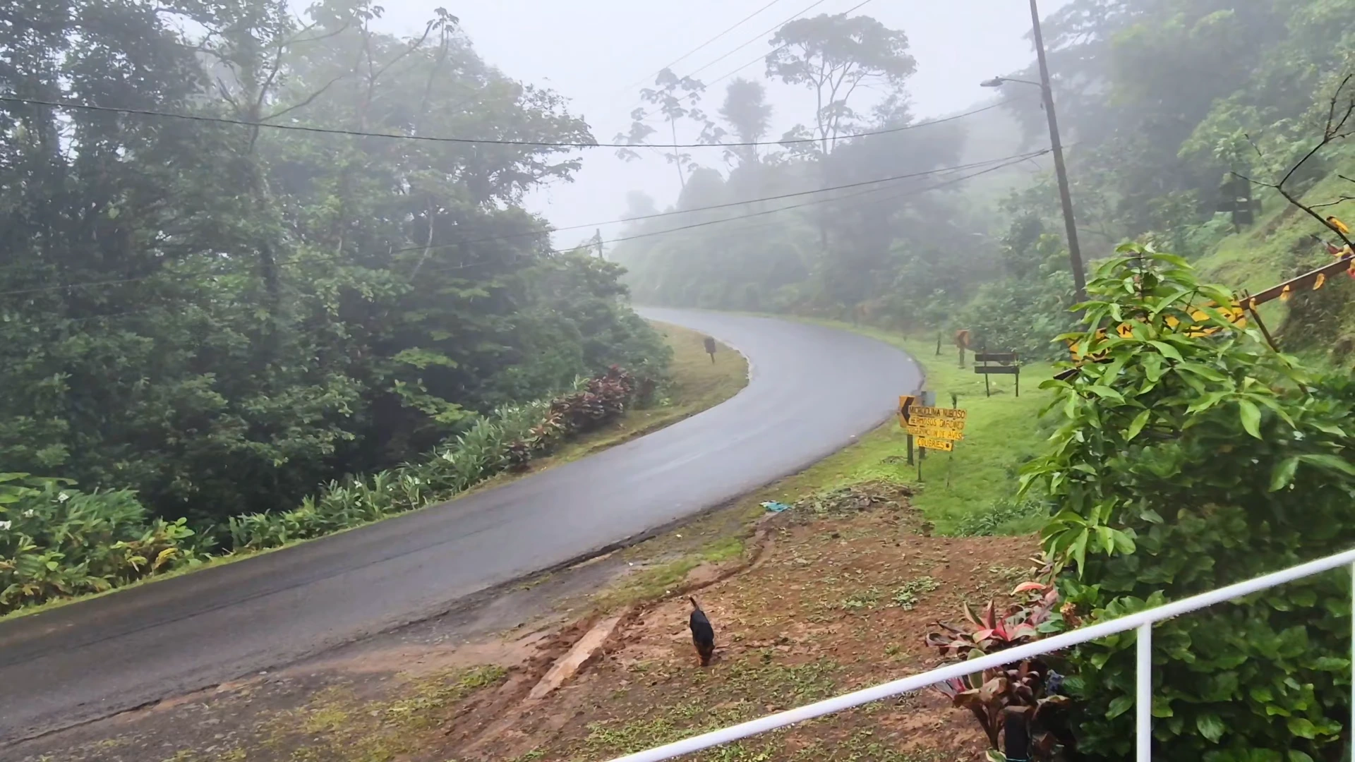
The mountain elevation around Grecia creates comfortable temperatures year-round. You’ll find it cooler here than the coast or lowlands. This makes it pleasant for walking around town and hiking to waterfalls. The climate stays green with regular afternoon rain showers.
Coffee fields cover the hillsides leading up toward Poás Volcano. The area stays lush and vibrant even during dry season. You can see the mountains from most vantage points in town. Views from accommodations like Tierra Nueva show why this region attracts people looking for mountain properties.
What Makes It Worth Your Time
Grecia provides local experiences without tour groups or resort complexes. The Friday farmers market brings together vendors from surrounding farms. They sell organic produce, honey, and prepared foods. The daily municipal market operates year-round with fresh ingredients and local products.
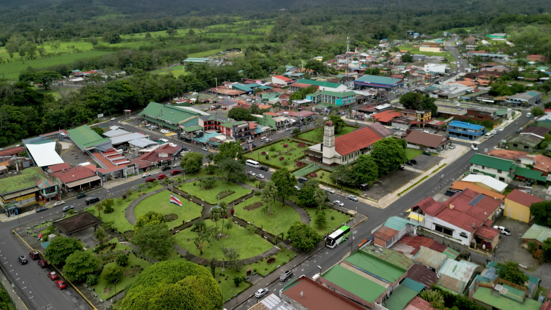
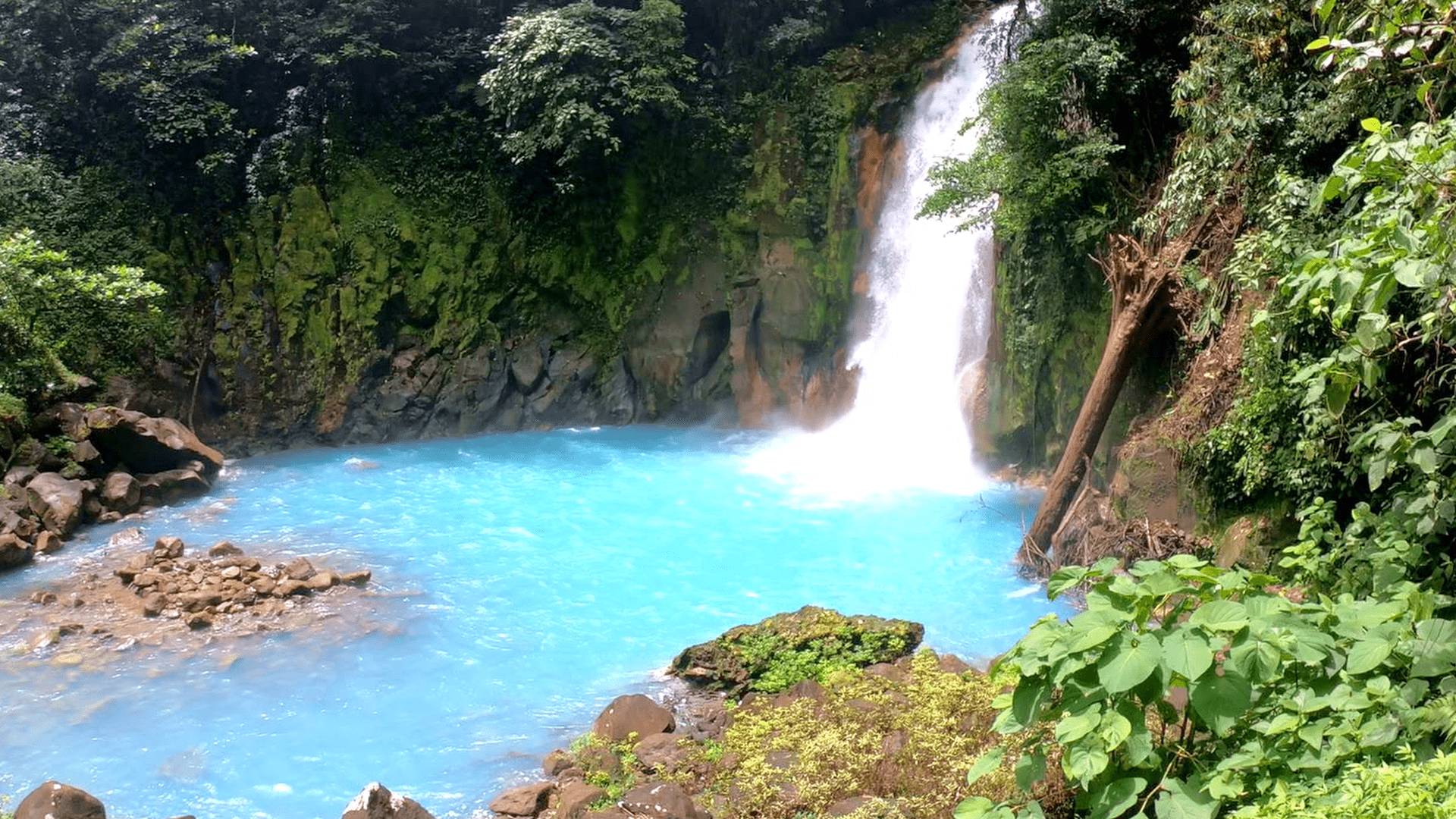
The town centers around a metal church imported from Belgium in the 1890s. You can walk the entire downtown area in 20 minutes. Catarata El Paraíso waterfall is only 5 minutes away by car. The hike takes just 10 minutes to reach it. Two days here gives you enough time to see everything without feeling rushed.
Grecia and the surrounding mountains are green year round.
Where to Stay – Tierra Nueva Glamping
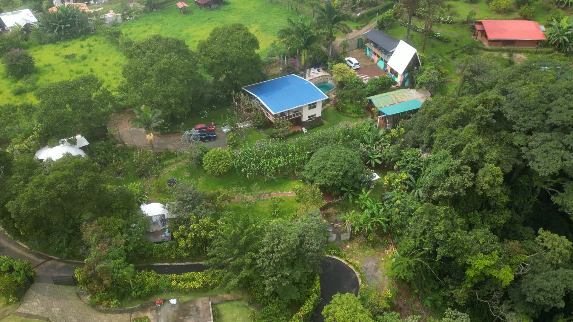
Tierra Nueva Glamping provides a unique mountain accommodation experience just 15 minutes from Grecia town center. The property has three geodesic domes scattered across the hillside, each with views of the surrounding coffee fields and mountains. You’ll stay in a comfortable tent structure with real beds, private bathrooms, and outdoor kitchenettes.
The location works perfectly as your base for exploring the Grecia area. You can reach it in a regular car without needing 4×4 capabilities. The final stretch to the property is gravel, but well-maintained and easy to navigate. From here, you’re close to both town attractions and natural sites like Catarata El Paraíso.
The Dome Accommodations
Each dome at Tierra Nueva has its own character and location on the property. The structures combine camping’s connection to nature with hotel-level comfort. You’ll find a proper bed with linens, a full bathroom with a large tub, and a small kitchenette area outside your dome.
The domes have fans for air circulation and large windows that showcase the mountain views. One dome is tucked under the trees near a river where you can hear the water at night. Another is higher up on the property with more open views. The third has its own secluded spot with a jacuzzi tub setup.
Property Amenities and Features
The property includes a swimming pool with curved edges designed for lounging. An old bus has been converted into a restaurant and bar with an upstairs lounge area. You can see the mountains and valley from the dining area, making it a great spot for morning coffee.
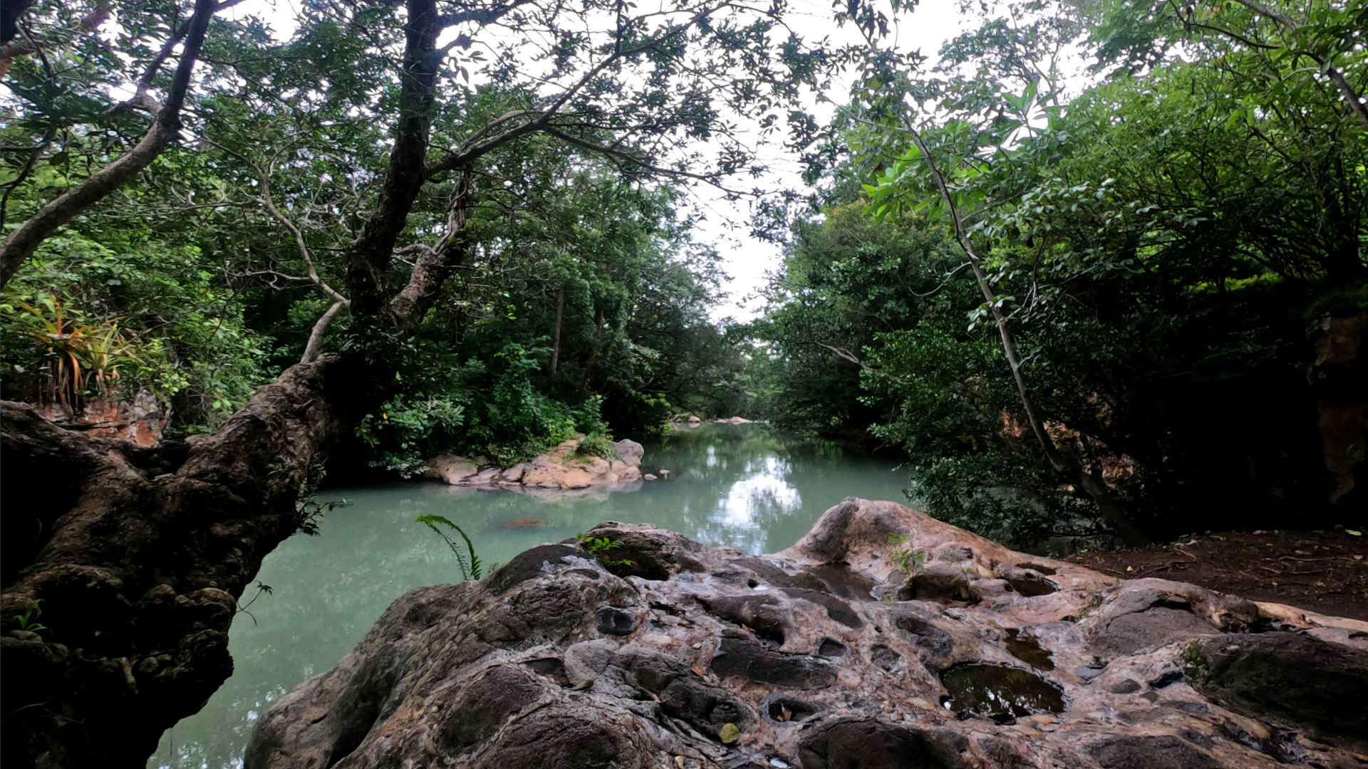
The grounds are well-maintained with walking paths connecting the different domes. You’ll find fruit trees including limes and bananas that guests can pick. The river running through the lower part of the property adds to the peaceful atmosphere, especially at night when you can hear it from certain domes.
Booking Information
Pricing at Tierra Nueva varies throughout the year based on season and demand. Contact them directly through their website or social media to check current rates and availability. The property works well for couples or small groups, with each dome accommodating two people comfortably.
Your first day in Grecia focuses on the town itself. Both attractions are within walking distance of each other in the compact downtown area. You can cover everything in a few hours. This leaves time to relax at your accommodation or wander around on your own.
The town follows the typical Costa Rican pattern. You’ll see a central park, church, and commercial area all clustered together. Everything is walkable. You’ll find local restaurants and cafes for meals throughout the day.
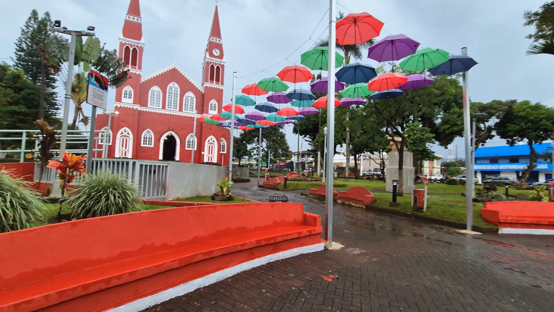
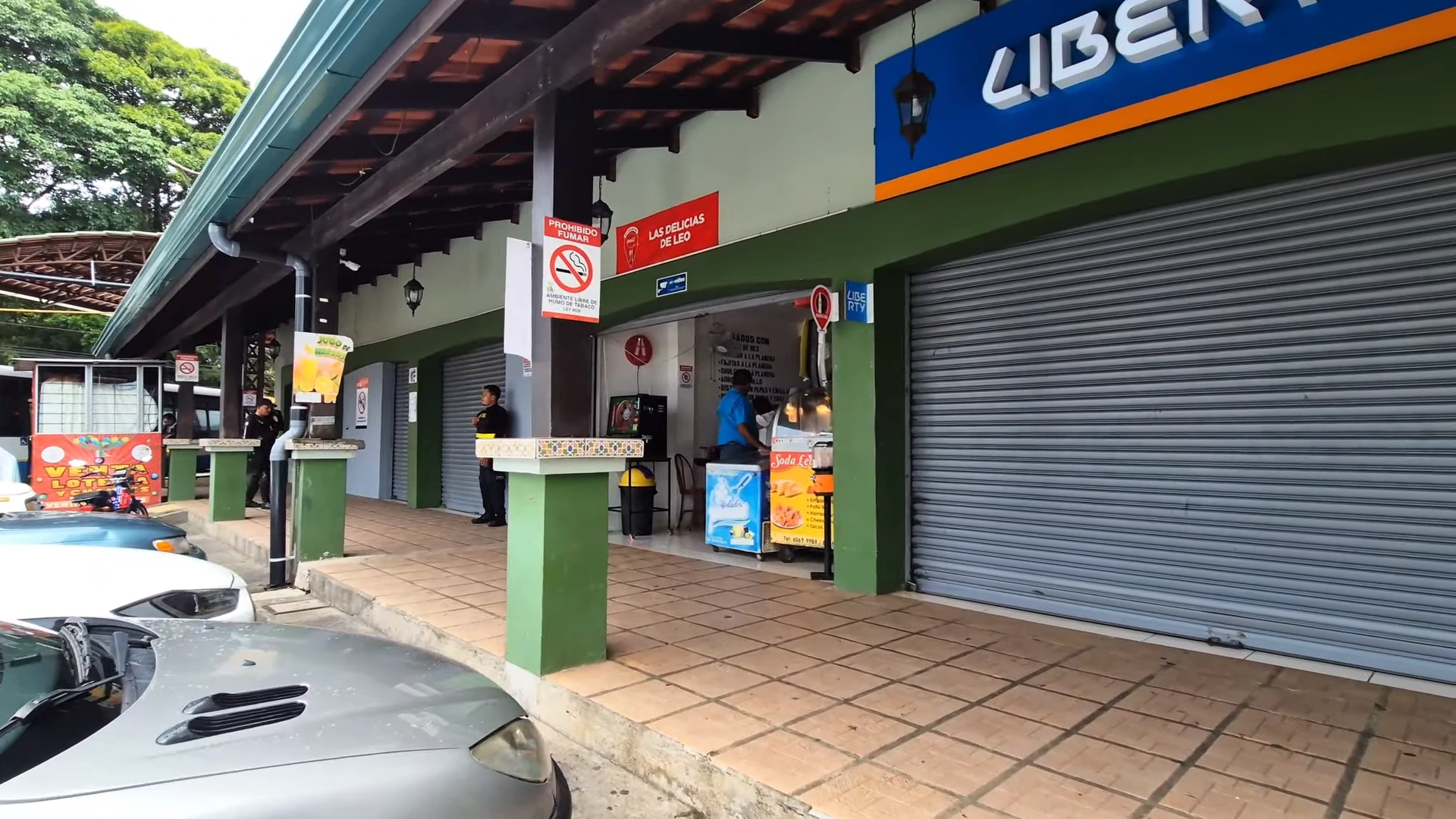
Downtown Grecia and the Church
The centerpiece of Grecia is its metal church. The red metal structure looks completely different from typical Costa Rican churches. It dominates the central square. You can walk inside to see the interior. The park surrounding it has benches and pathways where people hang out.
The downtown area extends a few blocks in each direction from the church. You’ll find banks, restaurants, pharmacies, and local shops all mixed together. There’s a Pali supermarket nearby if you need supplies. The compact layout means you won’t get lost exploring.
The Mercado Municipal operates every day just a few blocks from the central church. Locals shop here for fresh produce, meat, and household goods. Vendors sell fruits, vegetables, plantain chips, and prepared foods at stalls throughout the market.
The market has a covered structure with different sections. You’ll see produce in one area, meat in another. Prices run lower than supermarkets. The variety of tropical fruits and vegetables shows what grows in this mountain region. It’s worth a quick 20-minute walk-through to see daily Costa Rican life up close.
Day 2 – Nature and Markets
Day two takes you outside town to experience the natural side of Grecia. Start your morning at the waterfall before it gets crowded or rainy. If you’re visiting on a Friday, you can catch the weekly farmers market in the afternoon. This day balances outdoor adventure with local culture.
The waterfall requires some advance planning since you need to contact the owner for access. The farmers market only happens on Fridays, so adjust your itinerary accordingly if you want to see it.
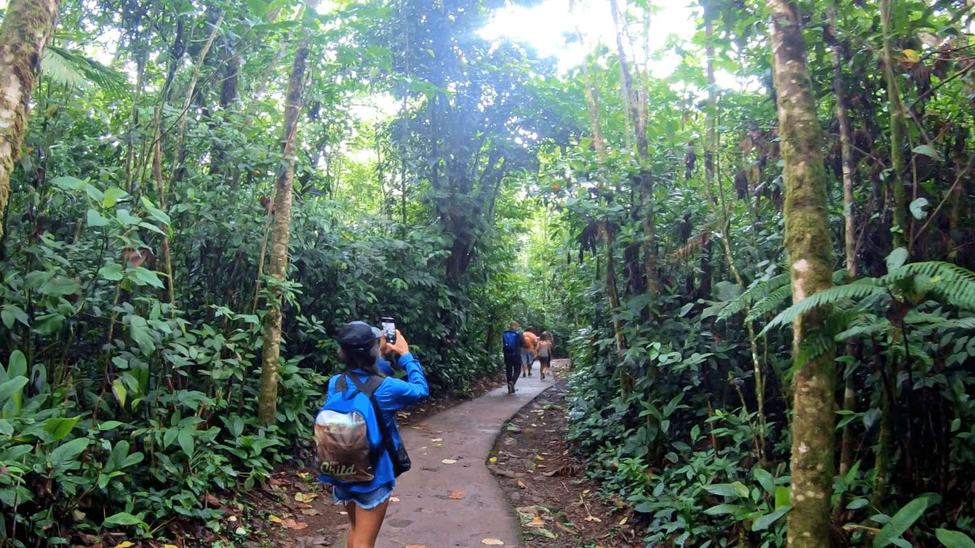
Catarata El Paraíso Waterfall (Morning)
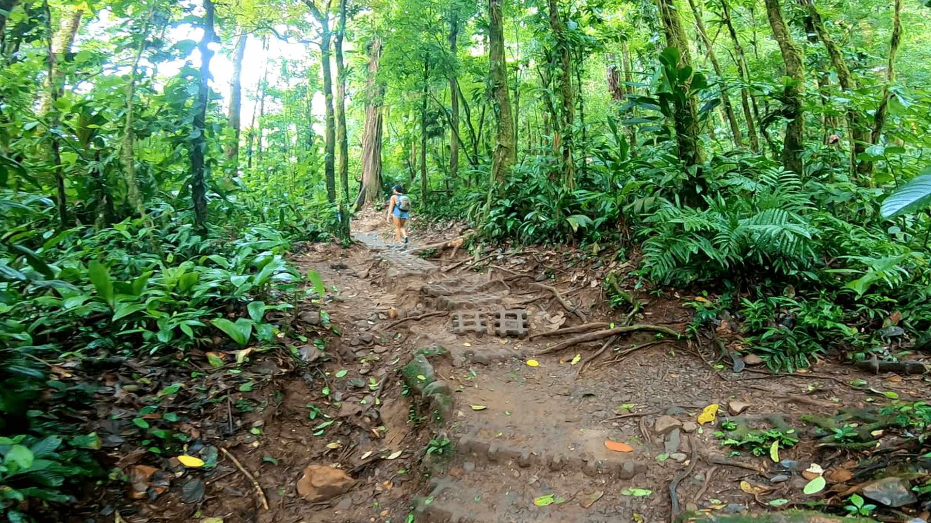
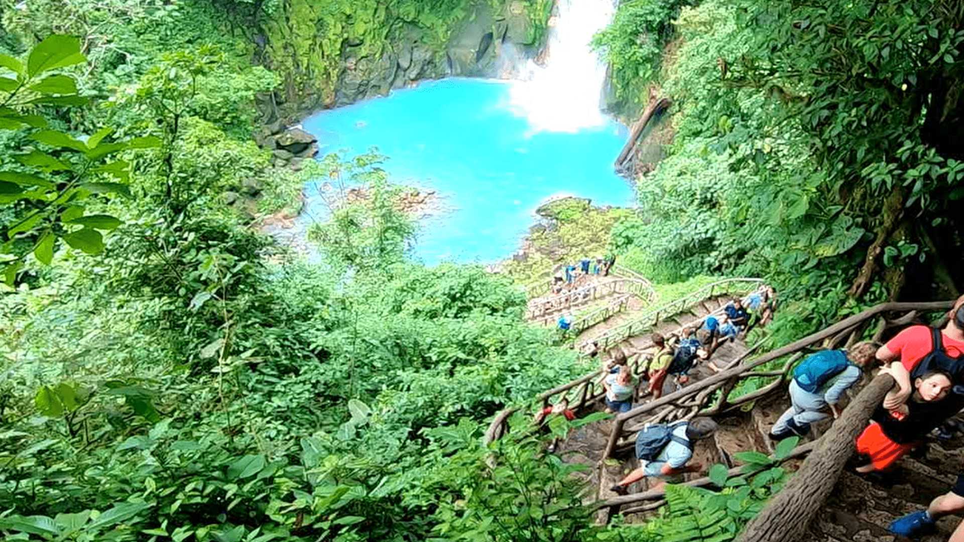
Catarata El Paraíso is located about 5 minutes from Tierra Nueva by car. You need to contact the owner Jorge via WhatsApp at +506 8588-4337 to arrange entry. The cost is 3,000 colones (about $6) per person. He’ll meet you at the gate and open it up.
The hike down takes about 10 minutes on a well-maintained trail. You’ll pass through a camping area with picnic spots and gazebos before reaching the jungle section. The waterfall runs heavy and creates a misty atmosphere at the bottom. There’s even a small water slide that feeds into a pool near the falls.
The property is best visited in the morning before afternoon rains roll in. Bring water shoes for the trail and swimming if you plan to get in the water. The camping area makes it possible to bring a cooler and spend more time there.
Friday Farmers Market
The Friday farmers market is much larger than the daily municipal market. It’s held in a circular building with covered parking around the perimeter. Parking costs 500 colones (about $1), and you pay when you exit.
Vendors come from surrounding farms to sell organic vegetables, fresh produce, honey, empanadas, and prepared foods. You’ll find everything from hydroponic lettuce to fresh juices to shopping carts full of tropical fruits. Several small restaurants operate inside the market serving local food.
The market gets busy around mid-morning but stays active through early afternoon. It’s a great place to stock up on fresh ingredients if you have kitchen access at your accommodation. Even if you’re not buying, it’s worth walking through to see the variety.
Practical Information
Grecia works year-round, but October through April offers the best weather with less rain. The Friday farmers market is the main reason to time your visit for a specific day. Otherwise, you can visit any day and still see the municipal market and town attractions.
You’ll need a rental car to get around comfortably. The drive from San José airport takes 30 minutes on paved roads. Parking in town uses an app and costs about $1/hour. The road to Tierra Nueva is mostly paved with a short gravel section that any car can handle.
Bring an umbrella for afternoon rain showers. Water shoes work well for the waterfall hike and any stream crossings. Have cash in colones for market purchases and the waterfall entry fee. Most restaurants in town accept cards, but smaller vendors prefer cash.
The elevation makes temperatures cooler than the coast. You might want a light jacket for evenings, especially at the glamping site. The area stays green year-round, so any season works for visiting.
If these blog posts and videos help plan your Costa Rica vacation, please support our channel.
Follow Us
Keep up with our latest Costa Rica travel videos and guides by subscribing to our YouTube channel. We regularly post new content showing real conditions across different regions and seasons.
Planning a trip to Costa Rica? Contact us — we help with itineraries, logistics, and finding the spots most tourists miss.
Frequently Asked Questions
How far is Grecia from San José airport?
Grecia is about 30 minutes north of San José International Airport (SJO). The drive follows well-paved roads through small towns. It’s one of the closest mountain destinations to the airport, making it perfect for a first or last night in Costa Rica.
Do I need a 4×4 to reach Tierra Nueva Glamping?
No, you don’t need a 4×4 vehicle. The road to Tierra Nueva is mostly paved with a short gravel section at the end. Any regular rental car can make the drive. The property is accessible without high clearance vehicles.
What day is the farmers market in Grecia?
The large farmers market happens every Friday and runs from morning through early afternoon. The municipal market operates daily if you miss the Friday market. The Friday market is significantly larger with more vendors and variety.
How do I visit Catarata El Paraíso waterfall?
Contact the owner Jorge via WhatsApp at +506 8588-4337 before visiting. Entry costs 3,000 colones (about $6) per person. He’ll meet you at the gate to provide access. The hike down to the waterfall takes about 10 minutes on a maintained trail.
Is Grecia worth visiting if I’m going to La Fortuna?
Yes, Grecia makes an excellent stopover on the way to La Fortuna. It’s directly on the route and eliminates the need to drive 3-4 hours after landing at the airport. You’ll experience authentic mountain life and avoid night driving on unfamiliar roads.
What’s the weather like in Grecia?
Grecia has a cooler mountain climate than the coast or lowlands. Expect comfortable temperatures year-round with afternoon rain showers common. Bring a light jacket for evenings. The area stays green throughout the year, even during dry season.
La Fortuna is Costa Rica’s adventure capital, sitting right at the base of Arenal Volcano about 2.5 to 3 hours northwest of San José. The whole region is packed with hot springs, waterfalls, zip lines, hanging bridges – basically every outdoor activity you can think of. Drive another hour past La Fortuna and you’ll hit Nuevo Arenal, this quiet mountain town on Costa Rica’s biggest lake where things slow way down.
I just spent a week in June exploring from La Fortuna all the way to Nuevo Arenal. It rained every afternoon for the trip, but it was well worth the journey. The volcano stayed hidden behind clouds most days. But there’s so much to do here it didn’t even matter. There’s a free hot spring where you can relax in the calm water. A rope swing at El Salto for a free adventure. Lake Arenal has a lakeside part where howler monkeys show up if you’re patient.
What I love about this area is nothing’s far apart. In La Fortuna you can walk the whole town in 20 minutes. But within 15 minutes you have waterfalls, hot springs, hiking trails. Want a break from tourist prices? Drive another hour to Nuevo Arenal. Quieter town, cheaper food, same incredible views. I’m going to show you the whole route from San José – where to stop, where to park, what’s actually worth your time.
Travel Tip: You don’t need to buy a SIM card when you land in Costa Rica to get data connection. With an eSIM, you’ll be able to configure your data connection before you depart for your vacation. I use the Saily eSIM in Costa Rica.
Most people rent a car at San José airport (SJO) for the drive to La Fortuna – it gives you freedom to explore and costs about $30-50 per day. The rental car desks are right outside customs, but here’s a tip: book online before you arrive. Walk-up rates are crazy expensive. You don’t need a 4×4 for this route, but get the full insurance. Costa Rica roads have potholes that appear overnight, and you don’t want to argue about damage you didn’t cause. Check out our complete rental car guide for Costa Rica before you book.
If driving isn’t your thing, there are other options. Direct public buses leave from Terminal San Carlos in downtown San José for about $5, but they take 4+ hours with all the stops. Private shuttles cost around $50-60 per person and pick you up right at the airport. Shared shuttles are good middle ground – door to door service, just a few more stops. Some people even fly to La Fortuna’s tiny airport, but at $150+ for a 30-minute flight, it’s pretty steep for the time saved. We cover both airport and transfer options in our Costa Rica airports guide.
Route 141 Through Zarcero
Taking Route 141 through Zarcero gives you some interesting stops along the way. From the airport, you’ll head toward Alajuela, then catch Route 3 to Grecia. Stop in Sarchí if you want to see those famous painted ox carts – though honestly, it’s gotten pretty touristy. The real gem is Zarcero, about an hour and a half from the airport.
Zarcero sits at 1,700 meters elevation where it’s always cool and misty. The town’s famous for its topiary gardens in front of the church – Don Evangelisto has been shaping these bushes into tunnels, animals, and abstract designs since the 1960s. Free to walk through, great coffee at the sodas around the park. Try the local palmito cheese if you see it.
After Zarcero, Route 141 joins up with Route 702 and you’ll drive through the same cloudy mountain section before dropping down to La Fortuna. The whole drive takes about 2.5 to 3 hours depending on stops. Park near the church but expect to pay a watch man 500 colones or so to keep an eye on your car.
Route 702 and Bosque Nuboso el Cocora
Route 702 is the direct path through San Ramón – what your GPS will probably suggest. San Ramón is your last real town for gas and supplies, so stop at the Auto Mercado if you need snacks or water. Everything costs more once you hit the tourist zone. About 20 minutes past San Ramón, you’ll start climbing into the cloud forest area.
Bosque Nuboso el Cocora is a nice stop if you want to break up the drive. It’s right on the main road – can’t miss the signs. They’ve got a butterfly garden with blue morphos, a small coffee shop, and some short hiking trails through the cloud forest. Entry is pretty reasonable, maybe $10-15 per person. The coffee’s good and it’s a chance to see the cloud forest up close without the windshield in the way.
Whether you stop or not, this whole section of road is stunning. You’re driving through legitimate cloud forest – misty, cool, with massive trees appearing and disappearing in the fog. The road winds like crazy through here. After about 30 minutes of mountain driving, you’ll start descending toward La Fortuna through pastures and little farming towns.
Road Conditions and Navigation Tips
Both routes have good pavement but lots of curves and elevation changes. The trickiest part is that cloud forest section where visibility can drop to nothing in seconds. Drive with your headlights on, even during the day. When locals pass you in the fog (and they will), just let them go. They know every curve by memory.
Waze is better than Google Maps here – locals update it constantly with police checkpoints, accidents, and road conditions. Download offline maps before you leave San José though. Cell signal gets spotty in the mountains. There’s one section everyone complains about – a rough patch of road right after the cloud forest where potholes multiply after every rain. Go slow, pick your line, don’t swerve suddenly.
Never drive these routes at night if you can help it. No streetlights, wandering livestock, and fog make it genuinely dangerous after dark. If your flight lands after 3pm, seriously consider staying near the airport and driving fresh in the morning. That said, early morning drives are magical – you’ll catch the sunrise over the mountains and beat all the tour buses to La Fortuna. Both routes take about the same time, so pick based on whether you want to see Zarcero or have a more direct shot.
Winding through the mist – This is Route 702 showing the winding roads over the mountains. You’ll often be driving inside the clouds.
La Fortuna Town Guide
La Fortuna is one of those towns that’s completely built around tourism, but in a way that actually works. The whole downtown is maybe six blocks by four blocks, centered around a main park with this big Catholic church. You can walk from one end to the other in about 20 minutes, which is nice when you’re trying to figure out where to eat or looking for tour operators. Just expect to get approached by guys selling tours every time you slow down.
The town gets busy, especially on weekends when Costa Ricans come up for the hot springs. Restaurants fill up, traffic backs up on the main strip, and finding parking becomes a real pain. But early mornings are magic – I’d walk to the park around 7am and have the whole place to myself. That’s when you get the best volcano views too, before the clouds roll in around 10 or 11.
Downtown Walking Tour
Start at Parque Central – the main park with the church. It’s well maintained with nice paths and benches under huge trees. The church itself (Parroquia San Juan Bosco) is worth a peek inside if it’s open. From there, the main tourist strip runs west past all the souvenir shops, tour operators, and restaurants. This is where you’ll find pretty much everything.
The Mega Super is tucked just behind the main strip near the soda where I ate gallo pinto for breakfast. Good prices on water, snacks, sunscreen – all the stuff that costs triple at hotel gift shops. There’s also a Palí on the edge of town if you need a bigger grocery run. Banks with ATMs are right on the main drag. Banco Nacional never ate my card, so that’s my recommendation.
Want to escape the tourist bubble? Walk a few blocks in any direction off the main strip. You’ll find local sodas, the public school, regular neighborhoods. I found this great little soda serving casado for 3,500 colones (about $7) just two blocks behind the church. No English menu, no inflated prices, just solid local food.
Parking in downtown La Fortuna is tough, especially near the popular restaurants. Most hotels are outside the town center, so you’ll probably drive in for dinner. Street parking is free but fills up fast. There’s usually a guy in a reflective vest who’ll “help” you park and watch your car. Give him 500-1,000 colones when you leave – it’s just how it works.
If your hotel’s within a kilometer or two, honestly just walk. The roads have decent sidewalks (not always common in Costa Rica), and it’s flat. Plus you avoid the parking hassle. Taxis are everywhere if you need them – figure 2,000-3,000 colones for rides around town. Uber works but isn’t as reliable as in San José.
For activities outside town, most tour companies include pickup from your hotel. That’s actually pretty convenient – no need to find these places on your own or worry about parking at trailheads. If you’re doing stuff independently like El Salto or the free hot springs, you’ll need your rental car. Both are only 15 minutes from town but not walkable.
Best Local Sodas and Restaurants
Let me be clear – you can spend $30 on a meal in La Fortuna or $6. The expensive places aren’t necessarily better, just fancier atmosphere. For cheap local food, I hit up Soda La Parada near where the buses stop. Their gallo pinto with eggs and sausage was 3,000 colones and seriously good. They take credit cards too, which isn’t always the case at sodas.
Downtown, everyone recommends Restaurante Travesia for nicer meals. Yeah, it’s good – they smoke their own meats and the atmosphere’s nice. But you’re looking at $15-20 per plate. Don Rufino is the fancy option if you want to impress someone. Personally, I’d rather eat casado three times a day and spend the money on activities.
One place that surprised me was the soda at the Blue Hotel. Manuel, the guy working there, was super friendly and the food was solid. Plus they’ve got that spa if you want to treat yourself after all the hiking. The Italian places downtown are decent if you’re craving pasta – Italiano Taverna is probably the best. But honestly? Stick to Costa Rican food. You can get Italian anywhere; you can only get proper gallo pinto here.
This is the soda I often get breakfast at when I’m in La Fortuna. They have Gallo Pinto at a great price, and they open early. It’s behind the Mega Super and Bus Station.
Free Activities Around La Fortuna
La Fortuna has plenty of free stuff to do if you know where to look. Yeah, the big attractions like zip lines and hanging bridges will run you $50-100 per person, but some of the best experiences don’t cost anything. I spent half my time at free spots and honestly enjoyed them just as much as the paid tours. You just need your rental car and maybe a few bucks for parking.
The trick is going early or late to avoid crowds. El Salto gets packed by 10am with tour groups, but at 8am you might have it to yourself. Same with the hot springs – late afternoon is a zoo, but early morning is peaceful. Plus, these spots are all within 15 minutes of town, so you can easily hit multiple places in a day.
El Salto Rope Swing Adventure
El Salto is this local swimming hole about 3 kilometers from downtown La Fortuna. Take the road toward the volcano, turn left after the church, and follow the signs. The road’s paved the whole way, crosses a couple bridges, then you’ll see cars parked along the road. That’s your spot. You can pay 1,000 colones ($2) to park at Soda Pollo nearby, or find a free spot on the road.
The main attraction is this rope swing over a deep pool where the river makes a natural swimming hole. When I went in the morning, some local guys were grilling chicken right by the water – said they come here every weekend. The rope’s attached to a tree branch maybe 15 feet up. You grab it from this sketchy platform made of roots and rocks, swing out over the water, and let go. Water’s probably 10-12 feet deep in the middle.
But here’s what I didn’t expect – there’s also a waterfall you can hike to. It’s maybe 5 minutes downstream, scrambling over some slippery rocks. Definitely wear water shoes for this. The waterfall pounds into another swimming hole, though the current’s stronger here. During rainy season, like when I visited in May, the water can rise fast. I went back one afternoon after heavy rain and the whole area was raging. The rope swing platform was underwater. Don’t even think about swimming when it’s like that.
Free Hot Springs at Río Tabacón
About 15 minutes west of La Fortuna on the road to Nuevo Arenal, you’ll find the free hot springs at Río Tabacón. Look for the bridge with “Tabacon” written on it – not the fancy resort entrance, but the actual bridge. Cars line both sides of the road. That’s where everyone parks. Miguel was working as a watch man when I went, charging $4 to watch your car. Worth it for peace of mind.
The hot springs are just the river itself, heated by underground volcanic activity. There are two main sections. Go left (upstream) from the bridge for the hotter, shallower pools. Local families have built little rock dams to create soaking pools. The water’s legitimately hot up here – like uncomfortably hot in some spots. Perfect for sore muscles after hiking.
The right side (downstream) is deeper and cooler, better for actually swimming. When I was there around 4pm, it was packed – probably 100 people. But talking to Miguel, he said mornings are way quieter. Just remember this isn’t a resort. No bathrooms, no changing rooms, no facilities at all. There’s a place across the street charging $20 per person for lockers and bathrooms if you need that stuff, but most people just change in their cars.
Central Park and Church Area
The heart of La Fortuna doesn’t cost anything to explore. Parque Central is where local life happens, especially in the evenings. The municipality keeps it really well maintained – nice paths, huge shade trees, benches everywhere. Kids play soccer on the basketball court while their parents chat on benches. It’s one of the few places in town that doesn’t feel completely touristy.
The Catholic church (Parroquia San Juan Bosco) anchors one end of the park. If you catch it open, pop inside – it’s got this cool wooden ceiling and usually pretty quiet. Best volcano views are from right in front of the church, assuming the clouds cooperate. Early morning before 8am is your best shot. By 10am, clouds usually roll in and hide the whole thing.
What I liked doing was grabbing coffee from one of the sodas around the park and just people watching for a bit. You see the real flow of the town – kids in school uniforms, locals heading to work, tourists looking lost with their giant backpacks. On Sundays, the park fills up with families after church. There’s usually a guy selling raspados (shaved ice) from a cart, and sometimes live music in the gazebo. It’s free entertainment and a good break from all the adventure activities.
Downtown La Fortuna, a compact and very easy to navigate town. You’ll find everything you need in the few blocks around the church and park.
Continuing to Nuevo Arenal
After a few days in La Fortuna, I was ready for something quieter. The hour drive to Nuevo Arenal completely changes the vibe – you go from tourist central to this laid-back mountain town where locals still outnumber visitors. The drive itself is worth doing even if you don’t stay in Nuevo Arenal. You’re basically circling Lake Arenal with volcano views on one side and the country’s biggest lake on the other.
Nuevo Arenal feels like what La Fortuna might have been 20 years ago. There’s one main road through town, a handful of restaurants, couple sodas, and that German bakery everyone talks about. No tour operators chasing you down the street, no overpriced souvenir shops. Just a quiet town where people actually live and work. Plus everything costs about 30% less than La Fortuna.
The Mountain Drive from La Fortuna
The road from La Fortuna to Nuevo Arenal is one of those drives where you’ll want to stop every five minutes for photos. Head west out of La Fortuna on Route 142 – same road as the free hot springs. You’ll pass Tabacon Resort, then start climbing into the mountains. The road’s paved and in good shape, just lots of curves and elevation changes.
About 20 minutes out, you hit these viewpoints where you can see the entire lake spread out below. There’s usually space to pull over safely. Morning drives are best – afternoon wind on the lake can get crazy, and I mean like push-your-car-around crazy. The lake’s known for windsurfing for a reason. Rainy season afternoons also bring thick fog that makes the narrow road pretty sketchy.
The whole drive takes about an hour if you don’t stop, but who doesn’t stop? Little settlements dot the route, most with at least one soda or pulpería. I grabbed coffee at a place called Lucky Bug about halfway – great lake views from their deck. You’ll also pass the entrance to Arenal National Park from this side, though most people access it from La Fortuna. Keep an eye out for coatis on the road, especially early morning.
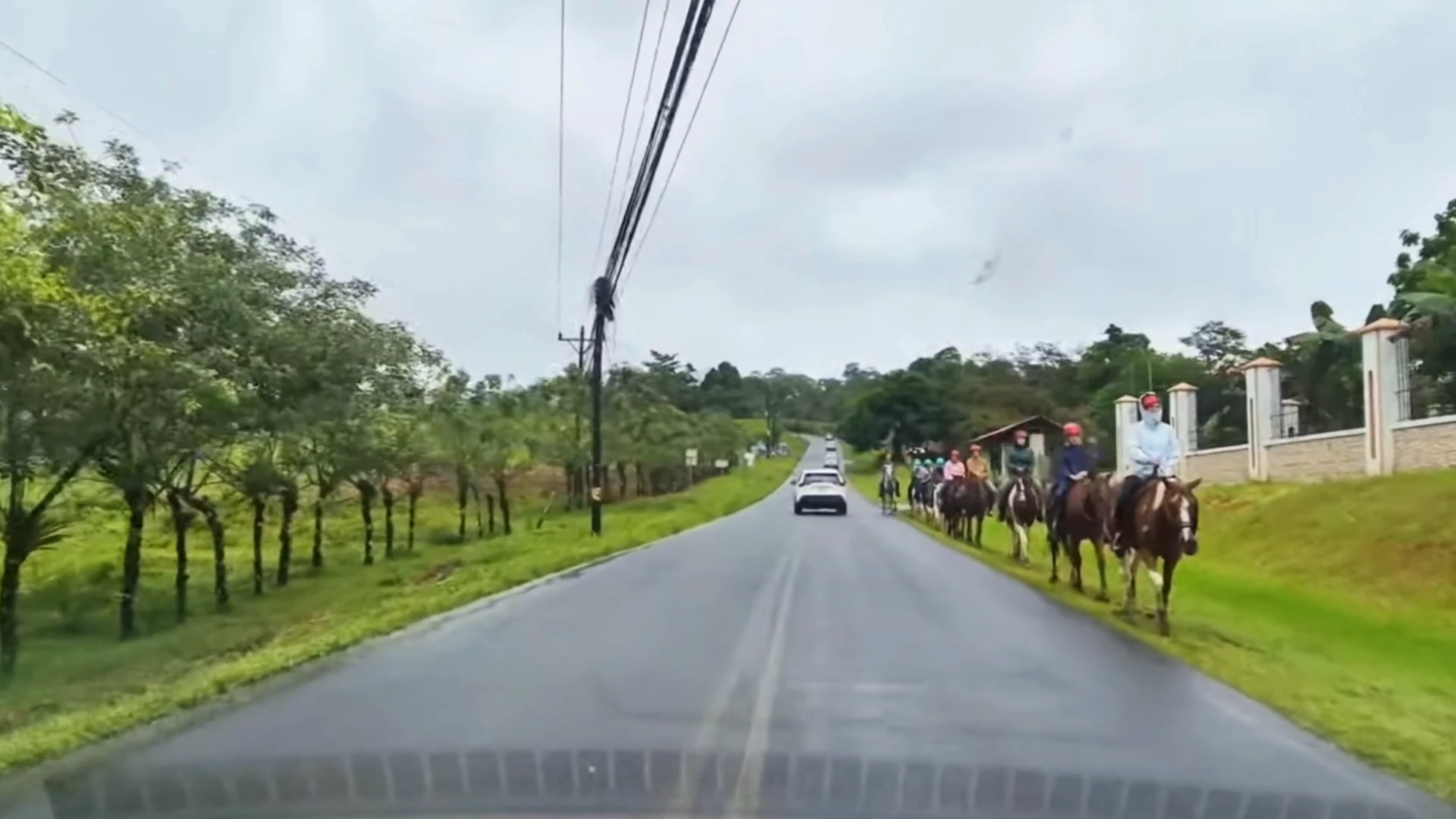
Spotted on the drive between La Fortuna and Nuevo Arenal, a large group on a horseback riding tour.
Nuevo Arenal Town Overview
The town sits about 1,700 meters up in the mountains, so it’s noticeably cooler than La Fortuna. Perfect if you’re tired of sweating all day. Everything happens along the main road – maybe a kilometer of shops, restaurants, and services. There’s a Guardia Rural station, couple banks with ATMs, small supermarkets, even a gym I noticed when walking around.
For food, I hit up Soda La Parada near the bus terminal. Their gallo pinto with eggs and sausage was 3,000 colones – half what you’d pay in La Fortuna for the same meal. They’ve got a nice covered area where locals hang out drinking coffee. The German Bakery everyone mentions is legit too. Good bread, decent coffee, and it’s become the de facto meeting spot for expats in the area.
What surprised me was how many expats live around Nuevo Arenal. Lots of Americans and Europeans have built homes in the hills above town. You’ll hear English at the bakery and see foreign license plates around town. But it doesn’t feel overrun like some expat havens. The town still functions primarily for Ticos, which keeps prices reasonable and the atmosphere authentic.
Lake Arenal Park and Activities
About 3 kilometers down the hill from town center, there’s a public park right on Lake Arenal. Look for signs to “Lago Park” or just follow the road downhill toward the lake. The park’s free, well-maintained, with picnic tables, bathrooms, and grassy areas perfect for hanging out. When I visited on a Tuesday morning, there were maybe five other people there.
The lake’s huge – Costa Rica’s largest – and the water’s surprisingly clear. I waded in for the obligatory water temperature test: refreshing but not cold. Locals fish from the shore, mostly catching guapote (rainbow bass). You can swim, though the afternoon winds create serious chop. Morning’s definitely better for water activities. I saw a few kayakers putting in from the park’s boat ramp.
Best part? The wildlife. I heard howler monkeys in the trees right above the parking area, then actually spotted them after about 10 minutes of looking. Tons of birds too – orioles, great kiskadees, even a toucan flew over while I was there. The park has some short trails along the lakeshore where you can explore. Nothing strenuous, just nice walks with lake views. There’s a cool butterfly garden near the entrance that some local family maintains – they were there working on it when I visited.
Practical Tips for Your Journey
After spending a week driving around the La Fortuna area in May, I learned some things the hard way. Rainy season travel is totally doable – honestly, I prefer it because there are fewer tourists and hotels cost half as much. But you need to adjust your expectations and come prepared. The rain’s not constant, but when it comes, it really comes.
The whole area from La Fortuna to Nuevo Arenal is set up for tourists, which is both good and bad. Good because you can find whatever you need. Bad because people know they can charge tourist prices. Learning a few tricks about parking, timing, and what to bring makes a huge difference in both your budget and enjoyment.
Rainy Season and Volcano Views
Here’s the reality about Arenal Volcano during rainy season: you might not see it. I was there five days and got maybe two clear views, both before 8am. The clouds roll in around 10am and just sit there. By afternoon, you can’t even tell there’s a volcano. Don’t plan your whole trip around getting that perfect volcano photo – you’ll just frustrate yourself.
That said, early mornings are magic. I’d wake up at 6am, grab coffee, and check the volcano. Twice I got lucky with completely clear skies. The light at sunrise hitting that perfect cone shape – worth every early wake-up. Even partial views are cool, with clouds swirling around the peak. Just don’t wait until mid-morning thinking it’ll clear up. It won’t.
For rain itself, expect downpours every afternoon starting around 2pm. Not drizzle – proper tropical rain that sounds like hammering on tin roofs. Plan indoor activities or hotel time for afternoons. Mornings are usually dry, so hit the trails and outdoor stuff early. The rain actually makes the hot springs better – sitting in hot water while cool rain hits your face is pretty incredible.
Watch men are everywhere in Costa Rica, and the La Fortuna area is no exception. These are guys who “watch” your car while you’re at attractions. It’s not officially required, but it’s part of the culture. At El Salto, free hot springs, even some restaurants – there’s usually someone in a reflective vest ready to help. Standard rate is 500-1,000 colones ($1-2) for a few hours.
Are they necessary? Probably not. Will your car be fine without them? Probably yes. But for a dollar or two, you get peace of mind and you’re helping locals make a living. Just make sure you have small bills – these guys rarely have change for a 10,000 colone note. I kept a stash of 500 colone bills just for parking.
In La Fortuna town, street parking is free but competitive. The watch men there are more aggressive about “helping” you park, even when you don’t need help. Downtown Nuevo Arenal is way more relaxed – often no watch men at all. At popular spots like the free hot springs, expect to pay $3-4 for watched parking. Miguel at Tabacon hot springs was super friendly and I felt good about supporting him.
If these blog posts and videos help plan your Costa Rica vacation, please support our channel.
Follow Us
Keep up with our latest Costa Rica travel videos and guides by subscribing to our YouTube channel. We regularly post new content showing real conditions across different regions and seasons.
Planning a trip to Costa Rica? Contact us — we help with itineraries, logistics, and finding the spots most tourists miss.
Frequently Asked Questions
How long does it take to drive from San José to La Fortuna?
The drive takes 2.5 to 3 hours via Route 702 or Route 141. Add extra time for stops in towns like Zarcero or if you’re driving during Saturday morning when locals head to the hot springs. First-time drivers in Costa Rica should add 30-60 minutes to GPS estimates.
Is it safe to drive from San José to La Fortuna at night?
No, avoid driving this route at night. The mountain sections have no streetlights, heavy fog, sharp curves, and wandering livestock. If your flight lands after 3pm, consider staying near the airport and driving fresh in the morning.
Do I need a 4×4 to drive to La Fortuna?
No, you don’t need a 4×4 for the main routes to La Fortuna. The roads are paved but have some rough patches after the cloud forest section. Any regular rental car can handle it if you drive carefully. High clearance helps but isn’t required.
What are the best free activities in La Fortuna?
The best free activities include El Salto rope swing (free entry, $2 parking), free hot springs at Río Tabacón ($4 for watched parking), and exploring Central Park and the church. All are within 15 minutes of town and best visited early morning to avoid crowds.
Where should I stop between San José and La Fortuna?
Stop in Zarcero to see the famous topiary gardens (free) and grab coffee. If taking Route 702, Bosque Nuboso el Cocora offers a butterfly garden and cloud forest trails for about $10-15. Both stops add 20-30 minutes to your journey.
When can you actually see Arenal Volcano?
Early morning before 8am offers the best chance for clear volcano views. Clouds typically roll in by 10am and stay all day, especially during rainy season (May-November). Don’t plan your whole trip around seeing the volcano – even partial views through clouds are impressive.
How much should I pay for parking in La Fortuna?
Watch men typically charge 500-1,000 colones ($1-2) in town, while popular attractions like the free hot springs cost $3-4 for watched parking. Always carry small bills as watch men rarely have change. Parking is part of the culture – it’s not required but provides peace of mind.
Is La Fortuna worth visiting during rainy season?
Yes, rainy season (May-November) means fewer tourists and hotels cost half as much. Rain typically comes in afternoon downpours starting around 2pm, leaving mornings dry for activities. Hot springs are actually better in the rain, and the landscape is incredibly green.
How far is Nuevo Arenal from La Fortuna?
Nuevo Arenal is about an hour’s drive from La Fortuna along Lake Arenal. The mountain road has incredible views but lots of curves. It’s a quieter alternative to La Fortuna with cheaper prices, a German bakery, and easy access to Lake Arenal activities.
What should I pack for La Fortuna?
Essential items include good water shoes with drainage and grip (not flip-flops), a cheap umbrella from a local supermarket, quick-dry clothing, reef-safe sunscreen, and bug spray. Bring more cash than you think – many sodas and parking attendants only accept colones.
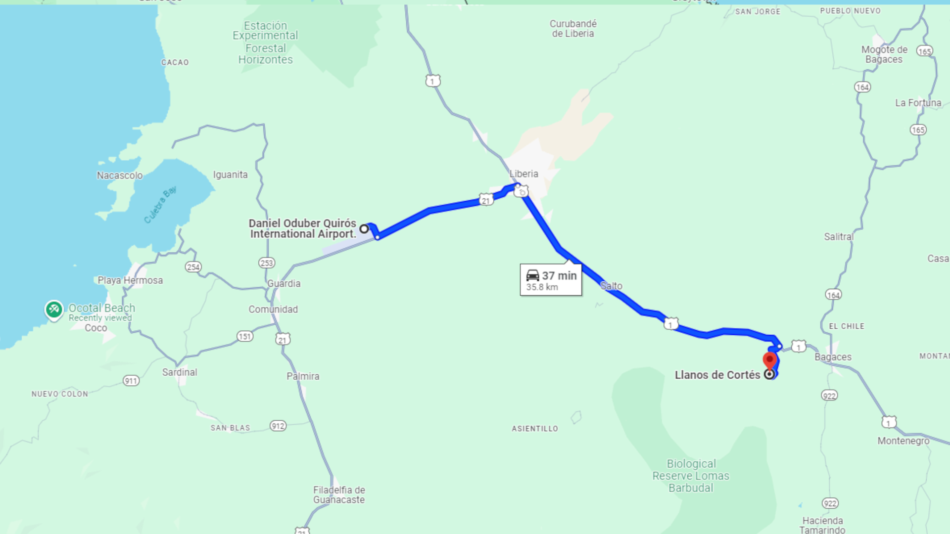
Just 30 minutes south of Liberia Airport, Llanos del Cortes stands out among Costa Rica’s waterfalls for its easy access and visitor facilities. The wide cascade drops over a rock face, creating a natural swimming pool below where a sandy beach area provides perfect spots for relaxing.
Unlike many waterfalls that require long hikes or rough roads, this one combines natural beauty with modern amenities. The maintained pathways, changing rooms, and organized parking make it suitable for visitors of all ages, while keeping its natural charm.
The site offers more than just the main cascade. Hidden trails lead to a secret pool upstream, and adventurous visitors can hike to viewpoints above the falls. Local vendors near the entrance sell snacks and crafts, making it easy to spend several hours enjoying the area.
Locations of Llanos del Cortes waterfall in Guanacaste Province, Costa Rica
Getting There
From Liberia International Airport
The route will take you south on the Pan-American Highway, an excellent divided road with little traffic. You’ll head south for about 20 minutes until you see signs for Bagaces. Look for the brown “Llanos del Cortes” sign – it can sneak up on you when driving at highway speeds.
Watch for the entrance road on your right. Once you turn, a gravel road leads to the parking area. Any car can make this drive – just take the gravel section slowly. The whole trip from the airport takes about 30 minutes without traffic.
Getting Supplies in Liberia
Before heading to the waterfall, Liberia offers your last chance for full services. Several supermarkets near the highway sell snacks and drinks. You’ll also find plenty of restaurants and gas stations. Grab water and snacks here, as options are limited at the falls.
The drive through Liberia town can get busy around rush hour. If you’re planning an afternoon visit, factor in extra time for city traffic, especially around the airport main intersection at the highway.
Bagaces Town Nearby
The small town of Bagaces sits just after the waterfall turnoff. You’ll find basic stores and sodas (local restaurants) here if needed. The town makes a good reference point – when you see signs for Bagaces, start watching for the waterfall entrance.
While most visitors drive straight through, it’s worth knowing you can find basic supplies here if needed. You can also find some accommodations options in the area if you intend to stay the night.
Pick up a pair of these awesome water shoes. I’ve been using them all over Costa Rica during my travels. They have vented soles so water drains right out the bottom!
Park Entrance and Facilities
Entry Details
The entrance booth sits at the start of the parking area. Current fees are $7 for foreign visitors and 2,000 colones for residents. Kids pay reduced rates. The park opens from 8 AM to 4 PM daily, with last entry at 3:30 PM. Staff give you wristbands when you pay.
After paying, it’s a short drive to the main facilities area. The road remains well-maintained – any car can handle it. You’ll often see tour buses here, as it’s a popular stop for day trips from nearby beach towns.
The entrance where you’ll pay your fee and continue down the road to the parking area.
Parking & Facilities
The main lot offers plenty of spaces with some shade. Clean bathrooms, changing rooms, and showers make it easy to prepare for swimming. A covered sitting area provides views of the falls and space to store your things.
Several local vendors set up near the path entrance, selling snacks, drinks, and local crafts. If you forgot anything or want souvenirs, bring cash for the vendors. They often have fresh coconuts and local snacks available.
Trail to the Falls
From the parking area, a well-built trail leads down to the waterfall. Concrete steps with handrails make the descent manageable for most visitors. The walk takes about 5-10 minutes, depending on your pace.
The trail can get slippery when wet, so take your time. While not a difficult walk, those with mobility issues should note it’s a steady downhill that you’ll need to climb back up later.
I use this sling backpack when I’m travelling in Costa Rica. It has a zipper lock to secure your stuff. I like the sling as I can flip the bag to the front for easy access.
The Waterfall
Main Falls
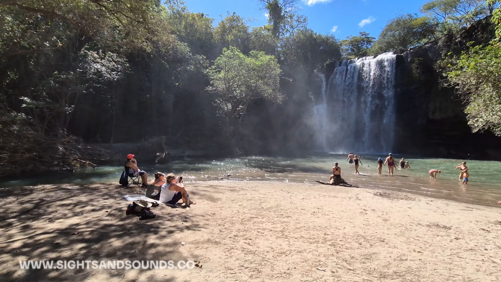
The wide cascade drops about 12 meters into a large pool, creating a constant mist that cools the air. A natural sandy beach area provides perfect spots for setting up towels and chairs. The falls face east, making afternoon a great time to swim in the shade of the falls.
Unlike many waterfalls that are tucked into narrow canyons, these falls spread wide across the rock face. This creates multiple streams of water and different viewing angles. Several rocky outcrops near the base make good spots for photos or just watching the water flow.
The waterfall of Llanos del Cortes and small beach area where you can relax.
Swimming Area
The main pool offers different depths for all swimmers. Near the beach, shallow areas work well for kids and casual relaxing. Deeper sections near the falls attract stronger swimmers. The water stays refreshingly cool year-round, providing relief from Guanacaste’s heat.
Most likely you’ll spend time between the beach area and swimming pool. The sandy bottom makes it easy to walk in, while large rocks along the sides provide spots to sit and enjoy the spray. Listen for the lifeguard’s whistle – they keep watch during operating hours and mark safe swimming zones.
Hidden Pool Trail
A less-used trail leads upstream to a secret pool above the main falls. This smaller pool is a spot away from the main area. The trail requires some basic scrambling over rocks, but the short walk rewards you with a peaceful swimming hole. Consider bringing some water shoes like the ones found in our Packing List.
Few visitors know about this spot, so you’ll often have it to yourself. The pool here is smaller but deeper than the main area. Large rocks around the edges make perfect spots for jumping in, though always check depth first as water levels can change.
Top of the Falls
For those wanting more adventure, a trail leads to viewpoints above the waterfall. The climb needs careful attention – stick to marked paths and avoid wet rocks. From the top, you’ll see the whole valley and watch the water drop below.
This trail isn’t maintained like the main path, so proper shoes and caution are needed. The view gives you a different perspective on the falls, and you can often spot wildlife in the surrounding trees. Time your visit for early morning if you want to explore up here – it gets hot quickly in Guanacaste sun.
Llanos del Cortes offers the perfect mix of natural beauty and easy access. The falls provide a refreshing break when traveling between Liberia Airport and beach towns, or as a day trip from nearby areas. Most visitors spend 2-3 hours here, making it an easy addition to any Guanacaste itinerary.
Remember to bring swimwear, towels, and water shoes if you have them. Early morning visits avoid both crowds and heat, though the falls stay refreshing all day. The combination of facilities and natural setting makes this one of the most family-friendly waterfalls in northern Costa Rica.
Follow Us
Be sure to Subscribe to the Youtube channel for more travel adventures from here in Costa Rica. We visit more waterfalls and rivers, as well as other attractions.
LLANOS DEL CORTES FAQ
Q: How much time should you plan here?
A: 2-3 hours typical visit. Factor in swimming time and drying off. Morning visits best for photographs and fewer people.
Q: What should you bring?
A: Swimwear, towels, water shoes helpful, change of clothes, water, snacks, cash for entry and vendors. Camera good for photos.
Q: Is it safe for kids?
A: Yes, sandy beach area good for families. Lifeguard on duty. Shallow areas for kids. Watch them on steps down to falls.
Q: What’s the best time to visit?
A: Early morning best for photos and fewer people. Avoid midday heat. Last entry 3:30 PM. Check road conditions in rainy season.
Q: How’s the access road?
A: Well maintained gravel. Any car can make it. Drive slowly. Clear signs from highway. Parking at falls.
Q: What facilities exist?
A: Changing rooms, bathrooms, showers. Covered rest areas. Local vendors sell snacks and crafts. Lifeguard during operating hours.
Q: How difficult is the trail?
A: 5-10 minute walk down steps. Handrails available. Can be slippery when wet. Moderate climb back up. Some benches for resting.
Hiking in Costa Rica means watching the landscape change as you move through different elevations. Each altitude brings its own climate, creating pockets where specific plants and animals have made their homes. The southern Pacific region shows this off well, with trails running from beach level up into the high mountain passes.
The microclimates here shape how you hike. Early starts help with coastal heat, while mountain trails need planning around afternoon clouds. Weather patterns change fast with elevation – you might need sunscreen and a rain jacket in the same backpack. Wildlife adapts to these changes too, with different birds and animals active at each level.
These elevation shifts mean you’ll see something different on every hike. Beach trails have their morning monkey troops and macaw flocks. Mid-elevation paths wind through dense forest where oaks and wild avocados grow. The highest trails break through the treeline into open air where winds sweep across mountain peaks. Each trail tells its own story about how Costa Rica’s mountains meet the sea.
I use these versatile trail runners on my hikes in Costa Rica. The aggressive grip tackles steep terrain while maintaining comfort for long days on mountain paths.
El Miro: Jaco’s Hidden Viewpoint Trail
The El Miro trail starts at the south end of Jaco beach, climbing steeply through forest to a dramatic clifftop viewpoint. From here, the entire curve of Jaco Bay stretches north, while the coastline south towards Playa Hermosa disappears into the distance. The morning light shows surfers catching waves below, while late afternoon brings spectacular sunsets.
Getting to the trailhead takes just minutes from central Jaco. Park near the south beach access, where a marked path leads into the trees. The climb takes 30-45 minutes, with some rope-assisted sections on the steeper parts. Early morning or late afternoon hikes avoid the midday heat.
This short but rewarding hike offers a completely different perspective on Jaco. While most visitors stick to the beach, this elevated viewpoint reveals how the mountains meet the Pacific. Macaws often fly past at eye level, and the breeze at the top provides relief from the beach heat below.
This hike is located at the south end of Jaco beach. You’ll cross the main highway and find the entrance across from Puddlefish.
At a brisk pace the hike will take 20 – 30 minutes. You can take some stops to spot wildlife and enjoy the art, and spend about 1 hour on the trail.
The trail is mostly moderate with a couple washed out areas that are rutted. Not recommended for those with mobility issues. Children can complete the hike under supervision.
Early morning before the heat or 2-3 hours before sunset for best views. Sunrise offers clearest ocean views, while sunset provides dramatic lighting across Jaco bay.
Water bottle, good walking shoes, camera for views. Phone for safety. Small backpack useful.
Hike with others when possible. Tell someone your plans. Watch footing on steep sections. Bring water even for short hike. Return before dark if hiking for sunset.
El Ascensión: Cloud Forest Peak Trail
The trail starts near the Pan-American Highway’s highest point, where clouds regularly sweep across the continental divide. This high-altitude hike offers rare access to Costa Rica’s páramo ecosystem, where stunted trees and unique vegetation adapt to life at 3,300 meters (11,000 feet).
Hidden behind a small restaurant at the mountain pass, this trail climbs through cloud forest before emerging into open páramo landscape. The stark transition from dense forest to alpine-like conditions shows how elevation shapes Costa Rica’s diverse environments.
The summit trail reveals both Caribbean and Pacific slopes on clear mornings, though clouds often roll in by mid-day. This ecosystem hosts unique highland species like the volcano junco and timberline wren, found nowhere else in Costa Rica.
Located at KM 89 of the Pan-American Highway (Cerro de la Muerte). There’s a wide parking area at the roadside. Trailhead starts at the road with 3,300 meters of elevation.
20 – 30 minutes to reach the summit at a steady pace. Plan for 1-2 hours total to enjoy views and return. Extra time needed for photography and bird watching.
High altitude makes this moderate trail more challenging. Some steep/very vertical sections near top. Trail clearly marked but rocky in parts. Take time to adjust to elevation before starting.
Early morning before clouds roll in (usually by 10 AM). Check weather as conditions change quickly. Clearest views December-April. Bring warm layers any time of year.
Warm jacket and layers (temps can drop below 10°C), hiking shoes with good grip, water, snacks, camera. Rain gear recommended year-round. Hat and sunscreen despite cool temps.
Watch for altitude symptoms. Start slow and stay hydrated. Tell someone your plans. Check weather before starting. Cell service available at trailhead. Return if weather turns bad.
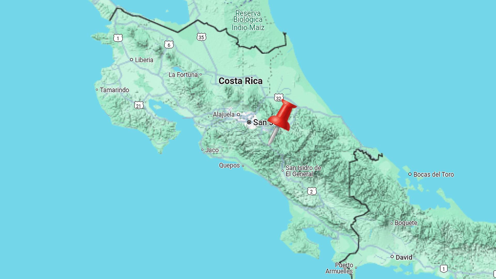
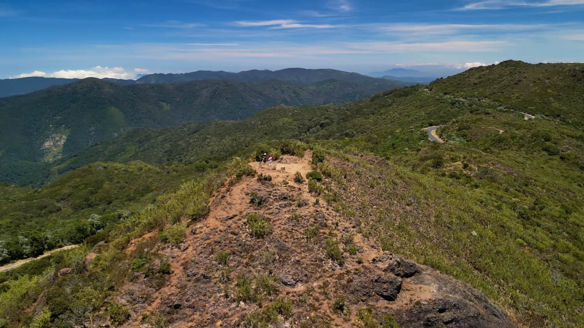
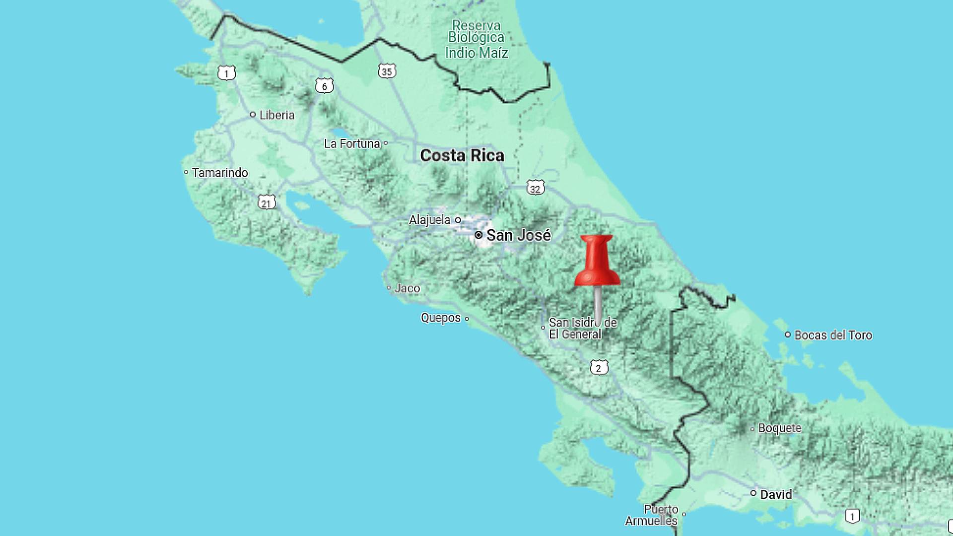
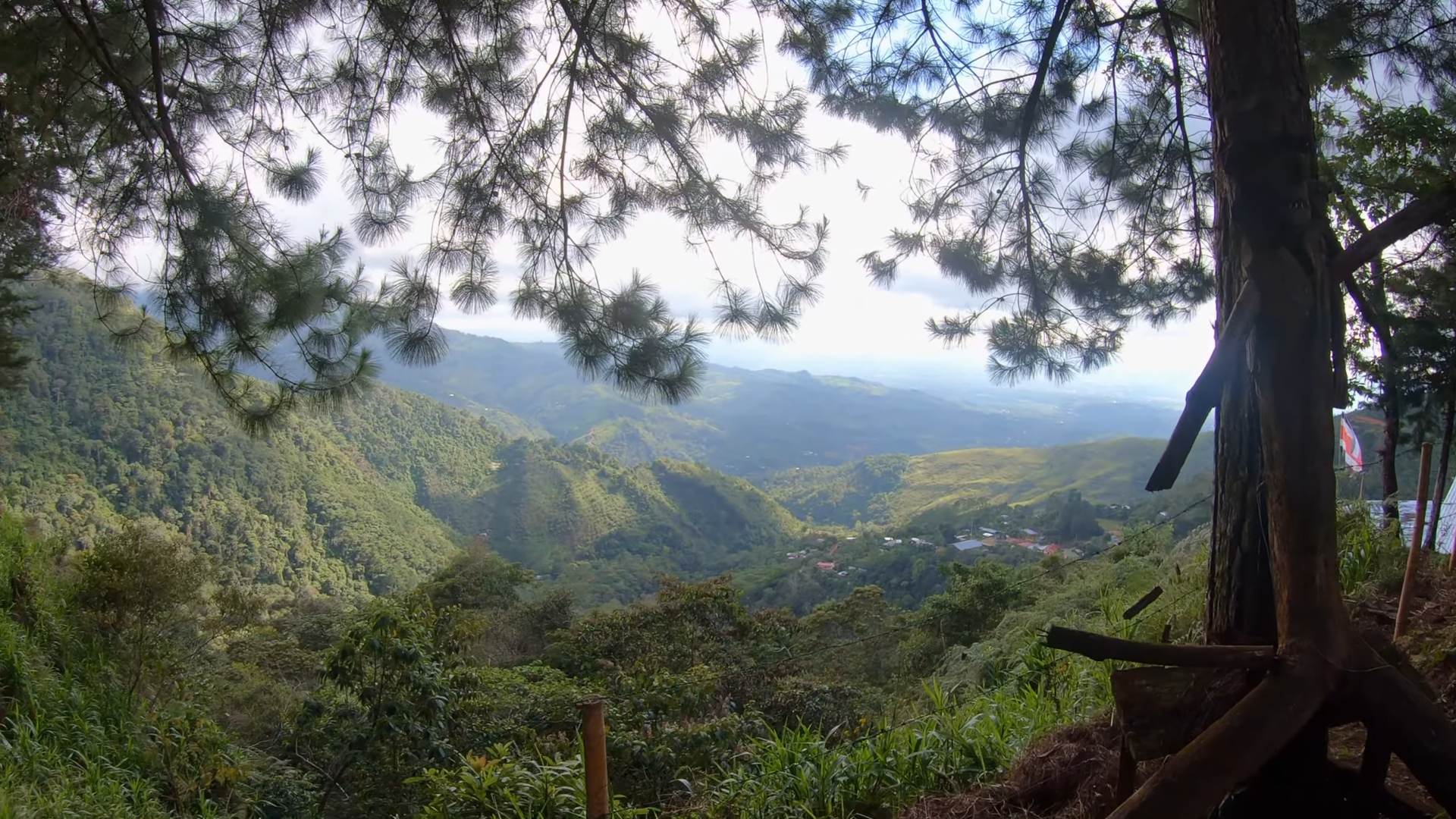
Los Gigantes: Valley View Trail
High in the mountains above San Isidro del General, the Los Gigantes trail network winds through working coffee farms into pristine forest. The trails offer sweeping views across the Perez Zeledon valley, where on clear days you can see all the way to the Pacific Ocean.
These paths started as coffee farm access routes but have evolved into maintained hiking trails. As you climb, the landscape shifts from sun-drenched coffee plants to cool forest shade. The elevation gain reveals how the valley’s patchwork of farms gives way to forest-covered peaks.
Multiple viewpoints along the way showcase the region’s agricultural heritage. Morning fog often fills the valley below before burning off to reveal the expanse of San Isidro and the surrounding mountains. Local farmers still use parts of these trails, making this a unique mix of working land and natural space.
Located in Perez Zeledon’s mountain region. Turn off the Inter-American Highway at San Isidro, follow signs toward Cerro Chirripo. Trail network starts near the community of Quebradas.
Main loop takes 2-3 hours at steady pace. Multiple trail options ranging from 1-4 hours. Worth taking time at viewpoints and rest areas.
Moderate with steady elevation gain. Well-maintained trails through farms and forest. Some steeper sections but regular rest spots available. Good for varied skill levels. You can drive to the top and walk across mostly level terrain to the giant trees.
Early morning before heat and for best valley views. Clouds typically move in afternoon. Dry season (December-April) offers clearest visibility.
Water, sun protection, light jacket for elevation, good walking shoes, camera for views, snacks. Cash for local stores if needed.
Tell someone your plans. Stay on marked trails to respect farm boundaries. Watch weather as afternoon rains common. Carry enough water as sources limited.
Subscribe For More
These three hikes show different sides of Costa Rica’s southern Pacific region, each offering unique views and experiences. From beach town overlooks to high mountain passes, and agricultural valleys, the diversity of landscapes here creates endless hiking possibilities.
Remember that conditions change throughout the year, so checking recent trail reports helps with planning. Each of these hikes works well as a half-day adventure, leaving time to explore the surrounding areas.
Subscribe to the YouTube channel for more Costa Rica hiking videos, trail updates, and hidden spots across the southern Pacific region.
Add Cueva Los Coyotes to your travel itinerary when you visit Costa Rica. It’s very close to the Liberia Airport, and well worth the low entry fee.
This spot is great for relaxing for the day, or swimming up the river in a tube.
Where Is It?
If you’re not yet in Costa Rica, be sure to checkExpediafor flights. Compare different dates, airports, and layovers to find the best price before you come check out the sloths.
Getting to Coyotes is super easy. Check out theGoogle Mapslisting that you can follow from your phone. It’s a quick drive north from Liberia, then a well marked turn towards the volcanos.
You’ll find a small booth at the parking area to Coyotes, where you’ll pay $2000 Colon for an adult and $1000 Colon for a child. For reference, that’s about $3 USD per adult. A very fair price for such a great activity.
Pick up a pair of these awesome water shoes. I’ve been using them all over Costa Rica during my travels. They have vented soles so water drains right out the bottom!
Float Or Swim
The staff at Coyotes will rent out large tubes for a low price. Be sure to bring some extra change.
Although tubes aren’t necessary, I recommend them for kids especially. If you’re a strong swimmer you’ll be able to easily swim your way up river. There’s multiple break spots along the way.
If you have water shoes or Five Fingers, I recommend bringing them. There’s cool spots you may want to check out along the rocks where more traction is beneficial.
Reach The Waterfall
After you make it through the first enclosed cave, you’ll reach a nice break location. Here you’ll find a shallow area of the river which is great for taking a break.
There’s a massive exposed root system coming down from above. The kids loved climbing the roots and jumping into the river below. Be sure to always check for depth and submerged trees before the kids start jumping.
A little further along the river, you’ll encounter a cool double waterfall. This location is enclosed by rocks above. The current is strong, but with a tube the kids were able to enjoy it easily.
You’ll notice in the video and pictures that the water is a little more hazy that ourprevious videos. We visited in late May, after the rain has started picking up.
If you’re looking to visit Coyotes when it has the picturesque blue water, try around December – March. This is the dry season and there’s less sediment in the river.
Follow Us!
Be sure to Subscribe to our Youtube Channel, and leave a comment with your thoughts about this location or request a video in other cool destinations around Costa Rica.
FAQ For Poza and Cueva Los Coyotes
What is Poza Los Coyotes? Poza Los Coyotes is a natural pool located in Costa Rica, known for its clear water and scenic surroundings. It’s a popular spot for swimming and relaxing in nature.
Where is Poza Los Coyotes located? Poza Los Coyotes is in the province of Guanacaste, Costa Rica. It’s near the town of Curubandé and within reach of Liberia, making it a convenient spot for a day trip.
How do you get to the swimming cave at Poza Los Coyotes? The swimming cave is accessible from Poza Los Coyotes. Visitors typically walk or swim a short distance to reach the cave, which is one of the main attractions of the area.
Is the swimming cave safe for all ages? While the cave can be an exciting experience, it may not be suitable for very young children or those who are not strong swimmers. The water can be deep, and the cave is dark, so it’s important to be cautious.
What should you bring when visiting Poza Los Coyotes? Bring swimwear, water shoes and a waterproof bag. Also, consider bringing snacks and water, as there are limited facilities nearby.
Are there any fees to enter Poza Los Coyotes? There is usually a small entrance fee to access Poza Los Coyotes, which helps maintain the area. The fee can vary, so it’s good to have some cash on hand.
When is the best time to visit Poza Los Coyotes? The dry season, from December to April, is the best time to visit. The water levels are stable, and the weather is generally pleasant. During the rainy season, access to the area might be more challenging.
Is Poza Los Coyotes crowded? Poza Los Coyotes can get busy, especially on weekends and during holidays. However, it’s generally quieter than more famous tourist spots in Costa Rica.
What wildlife might you see at Poza Los Coyotes? You might see a variety of birds, insects, and small mammals in the area. The natural surroundings are lush and home to diverse species, making it a nice spot for nature lovers.
Is there parking available at Poza Los Coyotes? Yes, there is parking available near Poza Los Coyotes, but it might be limited. It’s advisable to arrive early, especially on weekends, to secure a spot.
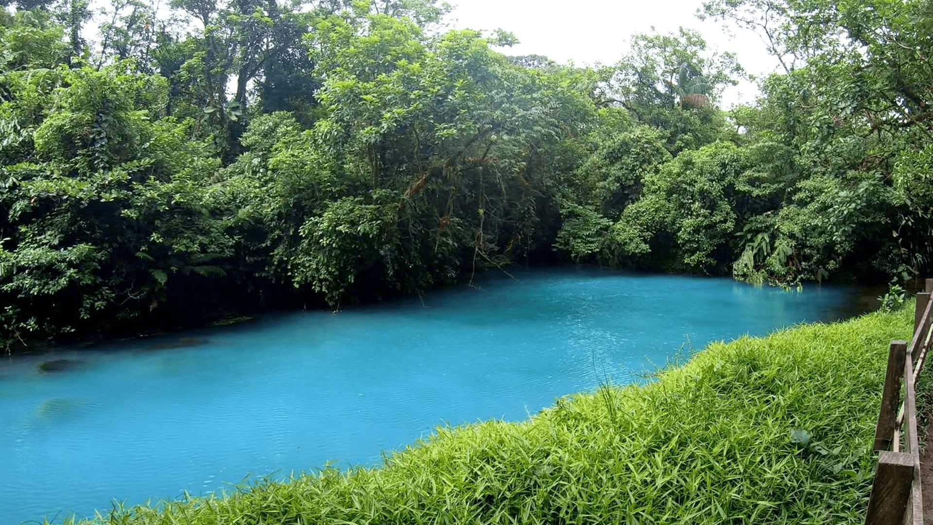
Rio Celeste runs through Tenorio Volcano National Park in northern Costa Rica. The river’s distinctive blue color comes from mineral combinations in the water, visible at several points along the hiking trail.
The park offers a maintained trail system leading to the main attractions: the waterfall, blue lagoon, and the teñideros where the color change occurs. The complete hike takes visitors through rainforest to each viewing area.
Visitors can observe the river from designated viewing platforms along the trail. The waterfall area includes stairs down to a closer viewpoint, while the teñideros show where two clear water streams combine to create the blue color. The trail system makes these natural features accessible while protecting the surrounding forest.
How To Get There
Once you’re in Costa Rica, you’ll find a few different routes to arrive at Rio Celeste. If you’re coming from Highway 1(the main north/south highway), you’ll be turning a few kilometers north of Canas.
Once you reach a small town called Bijagua de Upala, there’s a small road you’ll turn on. It’s called Cam. al Parque on Google Maps.
This road is winding and has great overgrowth, but use caution. Several sections of the road are concrete and can become slippery in certain conditions. Take it slow so you make it to Rio Celeste in one piece.
I use this sling backpack when I’m travelling in Costa Rica. It has a zipper lock to secure your stuff. I like the sling as I can flip the bag to the front for easy access.
What To Bring
The hike at Rio Celeste is pretty incredible, but it is a long one. You can expect to walk more than 5km if you want to see each location. This is up and down several mountains which are either stairs or rough terrain.
Only reusable water bottles are allowed in the park, and no snacks. There’s a security guard checking bags as well so be sure to show up with the proper gear.
The following gear is recommended for this hike:
Comfortable back pack
One liter of water per person in the pack. One additional liter waiting in the car.
Eat some snacks before departing.
Comfortable hiking shoes or boots. Be sure to wear socks.
Bug spray
Trekking Poles (if required)
Binoculars for animal viewing
Before you head out, be sure to think of anything else you might need. If you forget something, there’s a few stores in Bijagua de Upala which are large and have a wide selection.
Enjoy The Hike
This park has 3 primary locations to hike and visit. The closest is the waterfall. It’s very big, very blue and awesome to see in person. The path down to the waterfall is a stair case that was busy with people and kind of slippery. Take your time when you’re walking down to it.
The next area is the Blue Lagoon. This path is a bit farther and involves going up and down a winding and rough path. It would be difficult to traverse for somebody with mobility issues. Along the way, you’ll stop at The Mirador – Lookout. It will give you a great view of the mountains and valleys around the park.
The Blue Lagoon is really cool, it’s bright blue and fairly calm. You’ll definitely want to take a break here after the winding path.
Then at the very end, there’s the Mixing Point. This is a really cool area where a crystal clear river mixes with seeping mineral deposits. You can actually see where the minerals come up under the river and cause the water to turn blue.
During the hike we happened to see a few Vine Snakes, a Tucan, and some unique lizards. If you’re interested in a tour guide, there’s lots who can offer this service.
Follow Us!
Be sure to Subscribe to our Youtube Channel, and leave a comment with your thoughts about this location or request a video in other cool destinations around Costa Rica.
FAQ: Hiking to Rio Celeste
How long does the hike to Rio Celeste take? The hike to Rio Celeste typically takes around 3 to 4 hours round trip, depending on your pace and how long you spend at the various points of interest along the trail.
Is the hike to Rio Celeste difficult? The hike is considered moderately challenging. The trail can be muddy and slippery, especially during the rainy season, with some steep sections. However, it’s manageable for most people with a basic level of fitness.
When is the best time to visit Rio Celeste? The best time to visit Rio Celeste is during the dry season, from December to April, when the trail conditions are better and the river is most likely to be its iconic bright blue color.
Why is the water in Rio Celeste blue? The unique blue color of Rio Celeste is due to a chemical reaction between volcanic minerals and the river’s water. The phenomenon is best observed where two rivers meet, creating the blue hue.
Are there facilities along the hike to Rio Celeste? Yes, there are basic facilities at the park entrance, including restrooms and a small visitor center. However, there are no facilities along the trail itself, so be prepared with water and snacks.
Can you swim in Rio Celeste? Swimming in Rio Celeste is prohibited within the park to preserve the natural beauty and fragile ecosystem of the river. However, there are areas outside the park where you can swim in the same river.
What should I bring for the hike to Rio Celeste? It’s recommended to bring sturdy hiking shoes, plenty of water, snacks, insect repellent, and a rain jacket, especially during the rainy season. A walking stick can also be helpful on the muddy sections of the trail.
How do I get to Rio Celeste? Rio Celeste is located in Tenorio Volcano National Park. The most common way to reach it is by car from nearby towns like La Fortuna or Liberia. The park is about a 1.5 to 2-hour drive from these locations.
Is there an entrance fee for Tenorio Volcano National Park? Yes, there is an entrance fee to enter Tenorio Volcano National Park, which is where Rio Celeste is located. The fee is around $12 for foreign visitors and $2 for Costa Rican residents.
Are guided tours available for the hike to Rio Celeste? Yes, guided tours are available and can provide more insight into the area’s natural history and the unique phenomenon of the river’s color. Many tour companies will include transportation, entrance fees, and a guide who can for the hike.
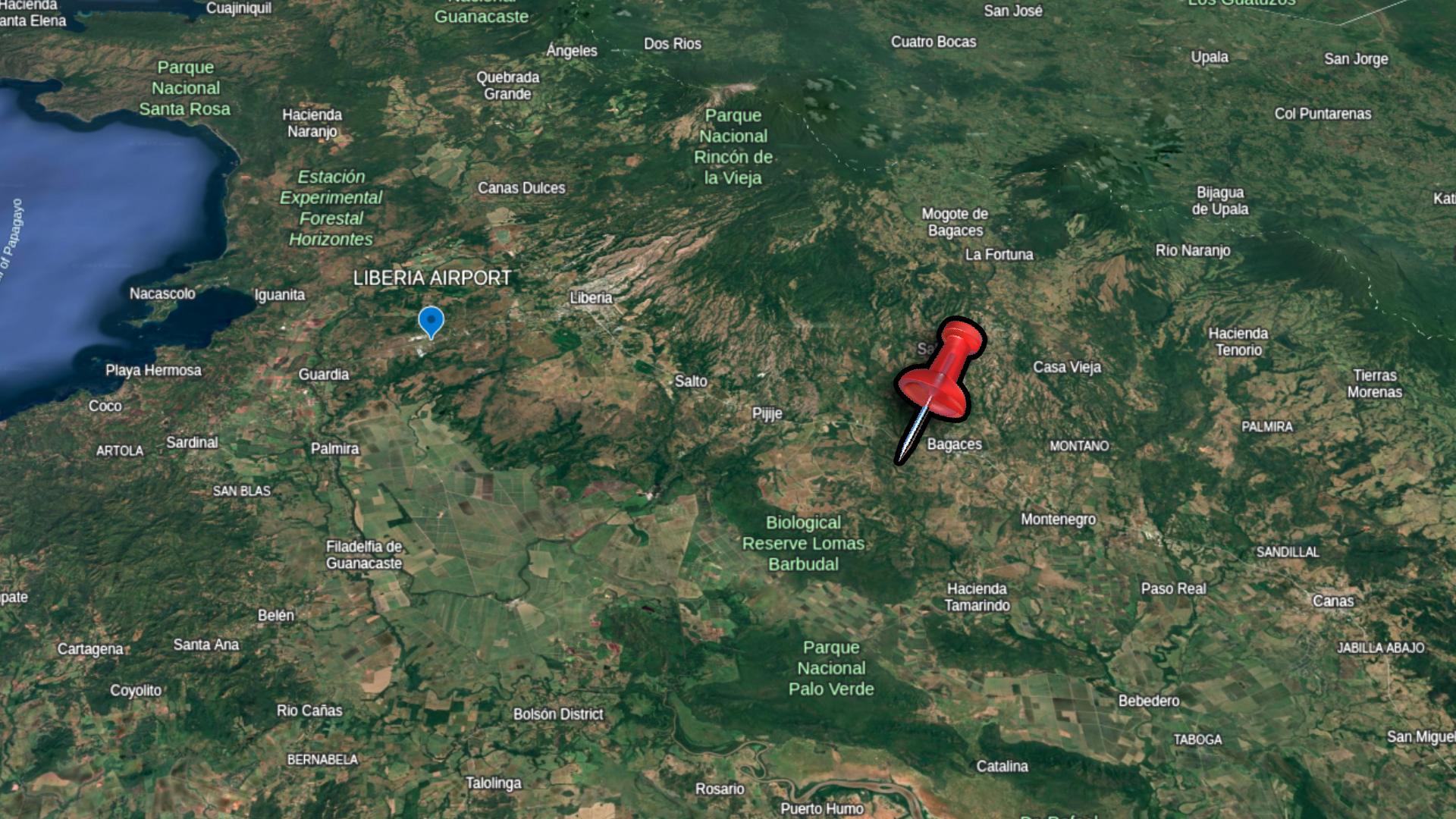
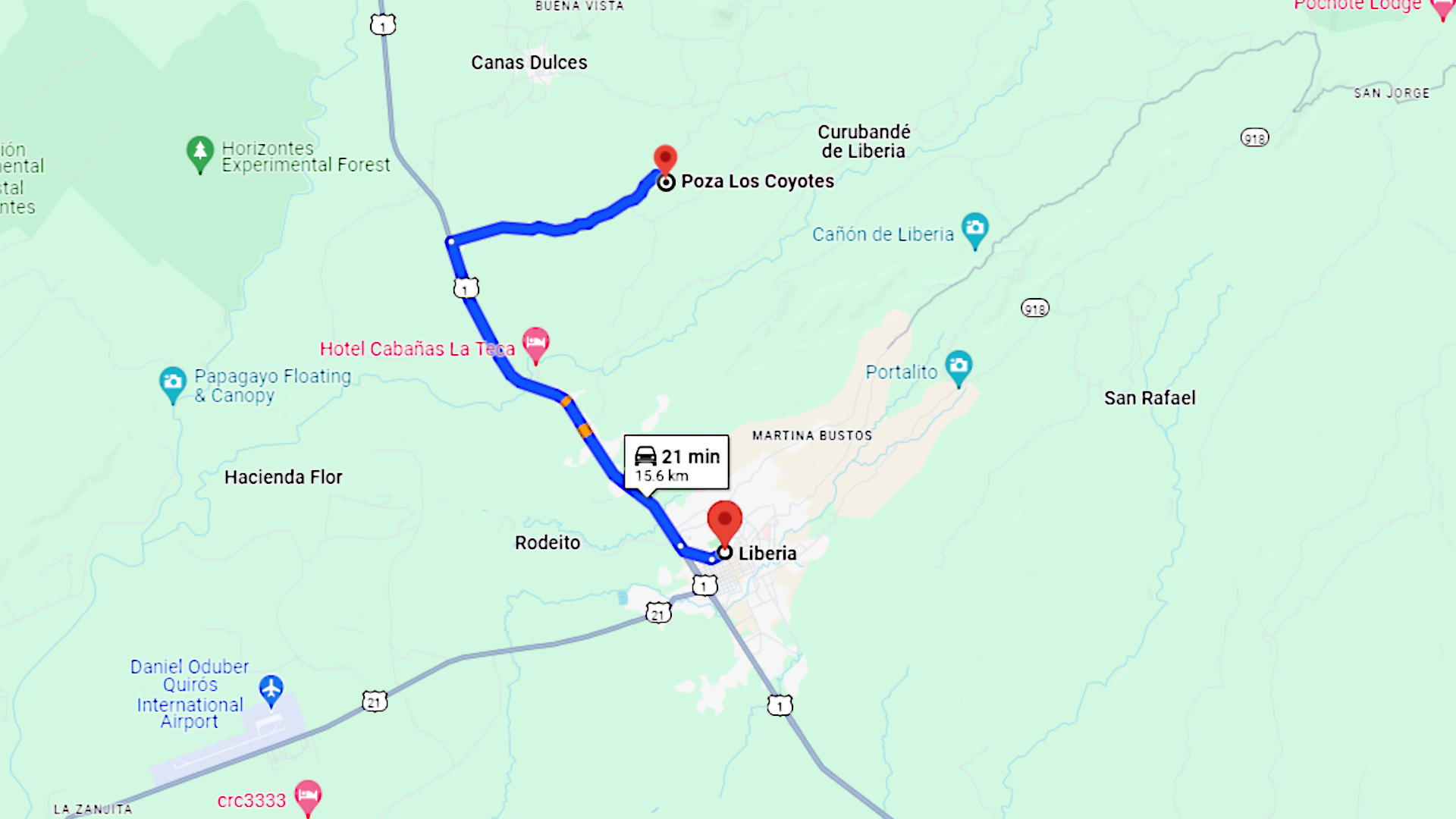
Just outside of the large city of Liberia in Guanacaste, you’ll find an amazing river system. It’s called Poza Los Coyotes, and it’s one of my favorite places in all of Costa Rica. In this blog post we’ll detail how to get there and what you can expect at this tourism hotspot.
Poza translates to pool in English. You’ll find this word describing locations that are on rivers and have a naturally formed area where you can swim. Keep an eye out on Google Maps for other Pozas in Costa Rica, or check out our Youtube channel for more videos with locations like this one.
Visit ourShop Pagefor a packing list of items I find useful when travelling. Don’t forget to pick up some sunscreen before spending a day at a location like Poza Los Coyotes.
Here’s a map of Costa Rica showing the location of Poza Los Coyotes. It’s in the northern part of the country, just north of Liberia.
Close To Liberia
Poza Los Coyotes is very close to Liberia and the International Airport. It’s a great destination to visit if your vacation is being spent in any of the surrounding locations. Places like Tamarindo, Playas del Coco and La Fortuna are within a day trip driving distance.
To find Poza Los Coyotes from Liberia, you’ll start by driving north on Route 1. This is the main highway which runs north/south through the province of Guanacaste. Drive about 10 kilometers, and you’ll see a clearly marked sign for Poza Los Coyotes. To ensure you don’t miss the sign, you can program the location into both Waze and Google Maps.
Once you turn on right, you’ll find a long gravel road. This road is very well maintained. Aside from a couple slightly rutted locations, it’s a very easeful drive. Just about any vehicle can make the trip to the final location.
You’ll be driving about 5 kilometers along this gravel road, be sure to watch for wildlife in the trees as your driving. You never know what you’ll see in Costa Rica. You’ll eventually reach an intersection where you’ll stay straight for just a short distance further.
Pick up a pair of these awesome water shoes. I’ve been using them all over Costa Rica during my travels. They have vented soles so water drains right out the bottom!
Arrival At Coyotes
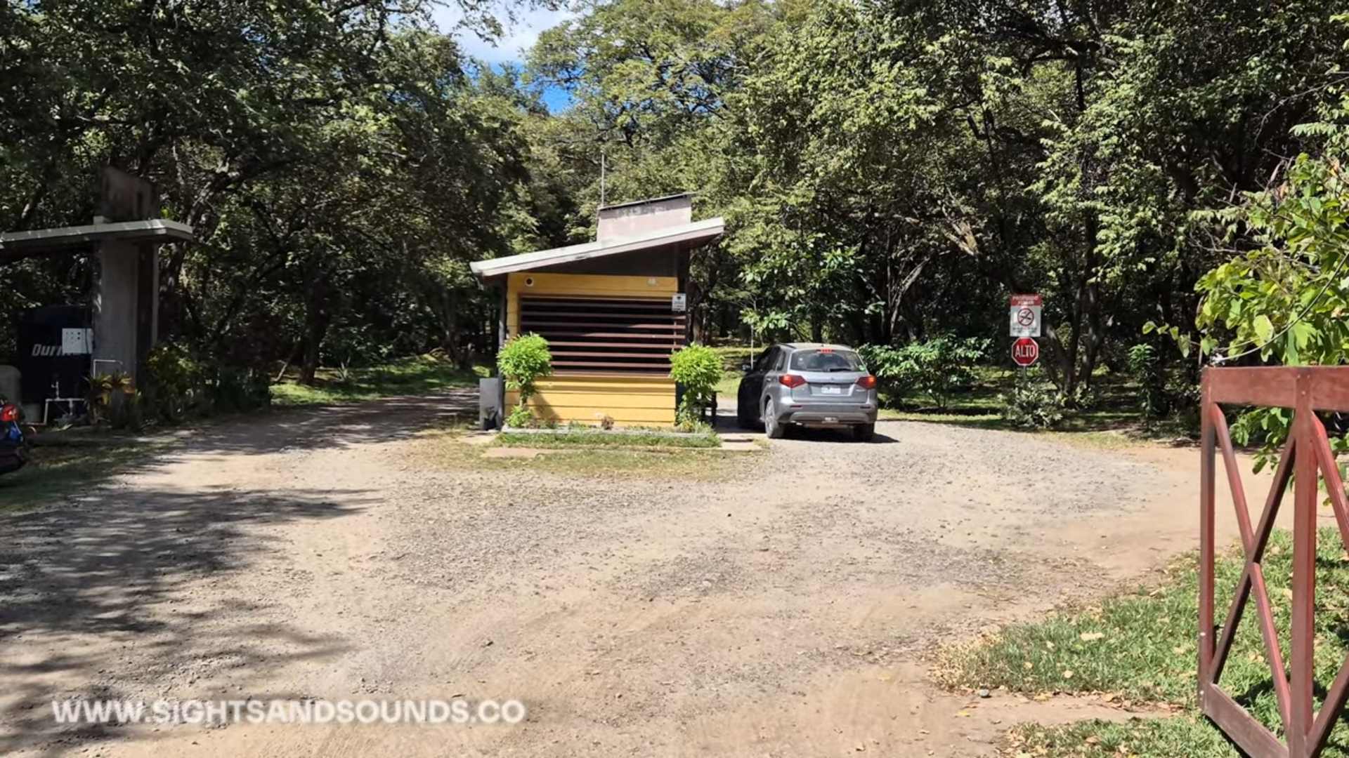
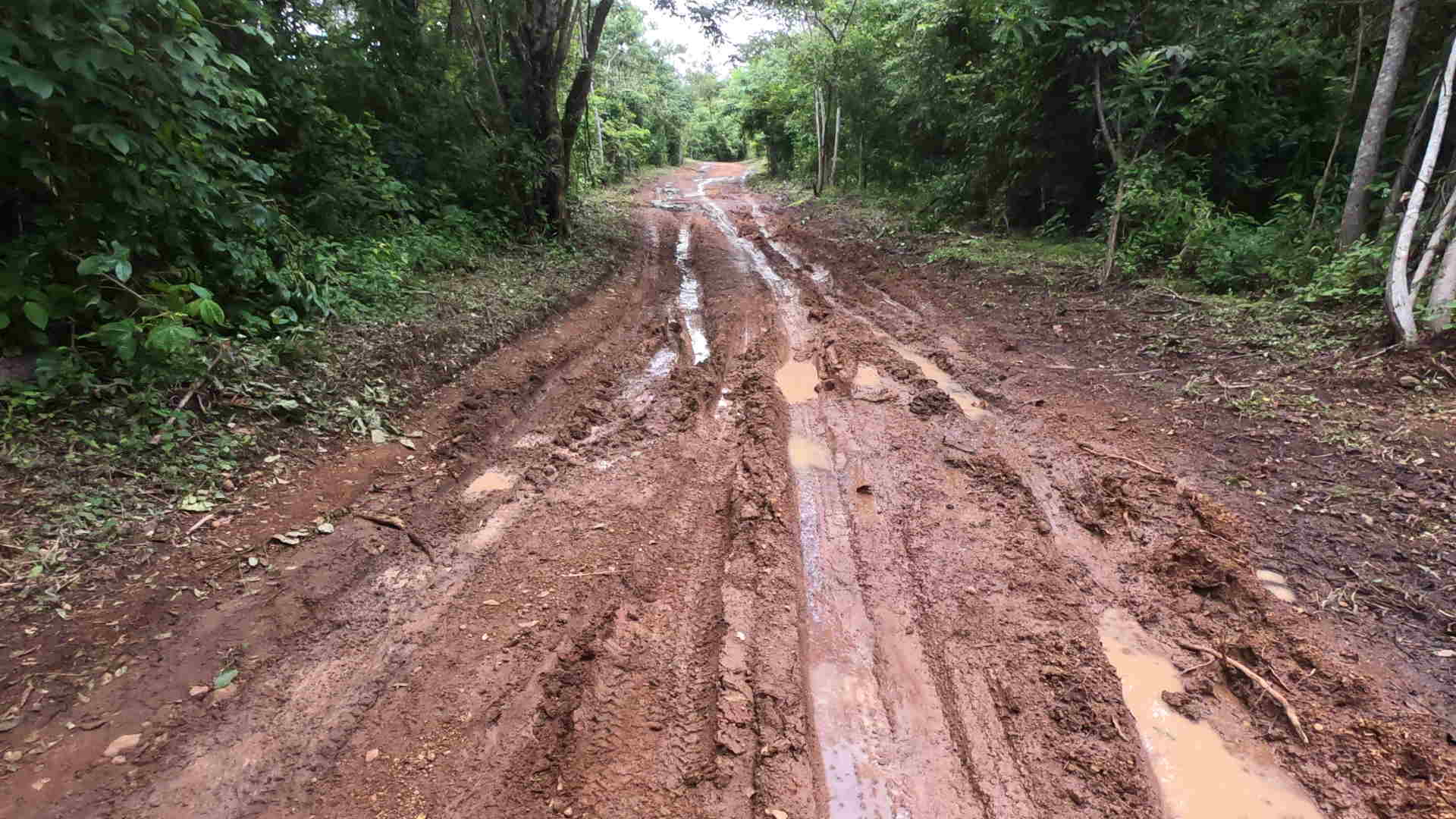
When you arrive at Poza Los Coyotes, there’s a clearly marked gate with attendant. The cost to enter at this location is 1000 colones/person. This is about $2USD. On our arrival, we were advised to park immediately at the gate and walk the remainder of the way down to the river. This was due to it being rainy season and the road being rough. On days I’ve visited in the dry season, we are able to drive right down to the river for parking.
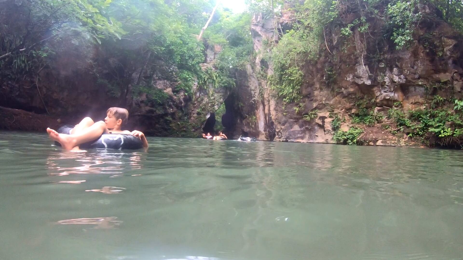
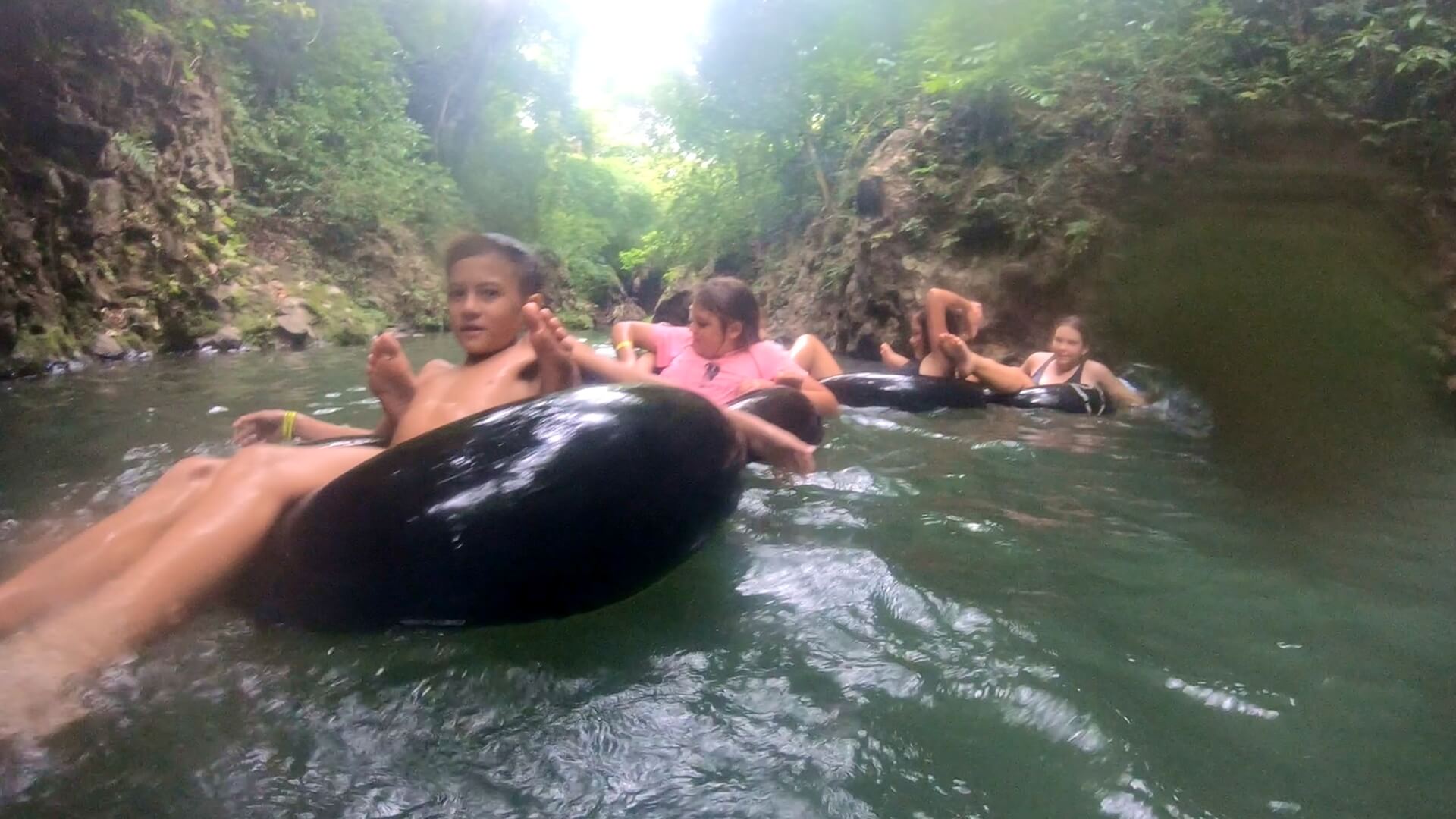
About 200 meters down this road, there’s a station renting out life jackets and inflatable tubes for 1000 colones. At the location where the equipment rentals are, the paths split in 3 main ways. Depending on what you’d like to see first, you can take your gear for a short hike.
Three Distinct Locations
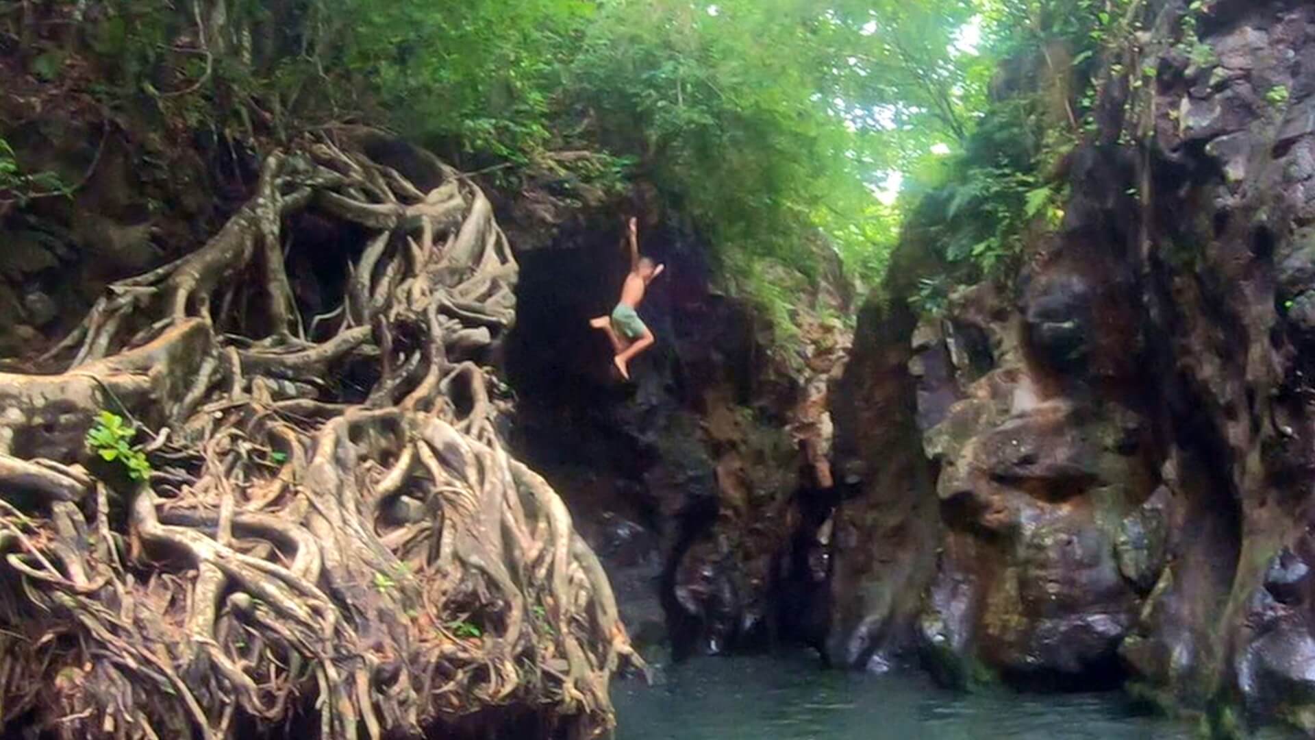
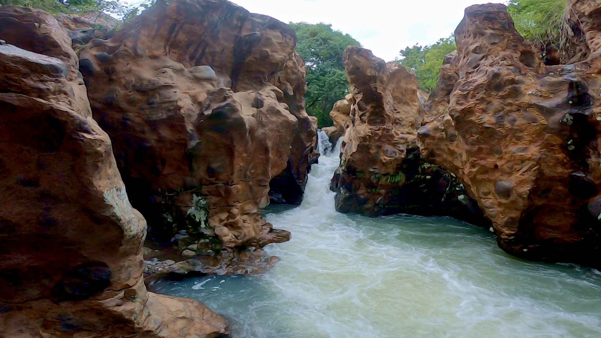
The first area, which is north along the river, will take you to a really nice area where you can jump in the water. We tried some higher jumps from about 20 feet after testing the depth ourselves. You can float around this area with an inner tube. If you venture further upriver there’s a cool little waterfall with a shallow area to relax. When we visiting the Pozas it had rained, so the water was a bit deeper in this part.
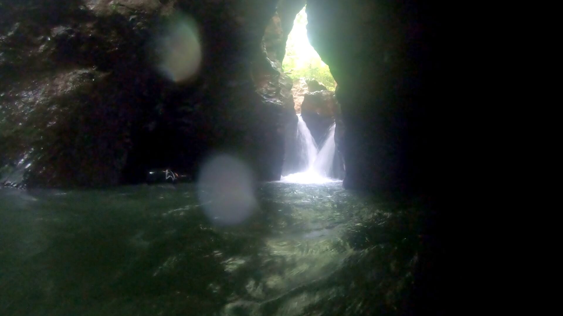
The second branch of path will take you do a picturesque part of the river, where water has cut through the rocks over time. The result is a strong current with small waterfalls and little pools of water which leads further into this chasm. The gentleman from the tube rental assisted us with locating the path to go directly down to the water where it’s power is clearly on display. It was a very memorable experience.
The third path, which is south from the rentals, will take you about 400 meters along the water. You can’t see the river from most of the path. Eventually you’ll find a slight hill which will take you to the bottom of the cascading waterfalls. This is where the inflatable tubes would be handy, as you will be able to float into the canyon with the rocks towering above you on either side.
Add It To Your Itinerary!
On the day we came, closing time at 6pm was soon, and the water appeared to be very powerful. For young kids it, the outflow from the canyons may have been too powerful to accomplish. Of course, in dry season with less daily rain and less powerful current, I anticipate that the canyon would be a very easeful and enjoyable swim.
Consider the cost and the proximity to Liberia, I highly recommend visiting Poza Los Coyotes. The water is blue as can be, and the flora is incredible.
Be sure to Subscribe to our Youtube Channel, and leave a comment with your thoughts about this location or request a video in other cool destinations around Costa Rica.
FAQ: Poza Los Coyotes in Guanacaste, Costa Rica
How do I get to Poza Los Coyotes? Poza Los Coyotes is located in Guanacaste, Costa Rica, near Liberia. You can reach it by driving along Route 1 (Interamericana Norte) and taking a sideroad which heads inland towards the volcanos.
Is there an entrance fee for Poza Los Coyotes? Yes, there is usually a small entrance fee to access the Poza Los Coyotes swimming area. It’s advisable to bring cash, as card payments may not be accepted.
What should I bring to Poza Los Coyotes? Bring swimwear, water shoes (the area can be rocky), a towel, sunscreen, and plenty of water. A waterproof bag for your belongings is also recommended.
Are the waters of Poza Los Coyotes safe for swimming? Yes, the waters in the natural pools are generally safe for swimming. However, be mindful of natural elements like slippery rocks and the strong waters in the caves.
Is Poza Los Coyotes family-friendly? Yes, Poza Los Coyotes is family-friendly, with shallow natural pools suitable for children. However, supervision is important due to the natural environment.
What is the best time of year to visit Poza Los Coyotes? The best time to visit is during the dry season, from December to April, as roads are easier to navigate and the weather is more predictable. The water is also more likely to be clear blue.
Are there any facilities at Poza Los Coyotes? Facilities are very limited. Plan to bring your own food and drinks. The staff have been building up more and more facilities as the destination becomes more popular.
Can I visit Poza Los Coyotes on a day trip? Yes, Poza Los Coyotes can be visited as a day trip from nearby towns like Liberia or Playas del Coco. Many visitors also combine it with other nearby attractions like Llanos de Cortés waterfall.
Is Poza Los Coyotes accessible by public transportation? Public transportation options are limited. It’s best to visit by renting a car or joining a tour, as the area can be remote and the roads may be rough. You can also reach the site by bicycle.
Are there guided tours available for Poza Los Coyotes? Yes, some local tour operators offer guided tours that include transportation to and from Poza Los Coyotes. These tours often combine visits to other local natural attractions as well.
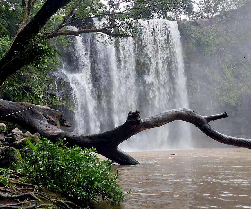
Today we’ll be visiting waterfall Llanos de Cortes. This waterfall is in Guanacaste, about 20 minutes south of Liberia. The waterfall and hike are a better known tourism destination, and very popular due to the ease of access. The road from Liberia is in great condition, and this waterfall is accessible by all vehicle types.
Before you book your flights to Costa Rica, be sure to check out ourPacking List. You’ll find stuff that I use when I’m traveling in Costa Rica.
Getting There
Arriving at the waterfall is very easy. Simply go through Liberia and head south. Just before the town of Bagaces, you’ll be looking for a right hand turn. There are signs on the road, but keep an eye out as this is a highway and you won’t want to drive right past. You’ll be looking to take the first right turn to the public parking area. You’ll pay an admission fee is just under $10 for this access point.
The hike down to the waterfall area from this parking lot is easy and short. It’s best to carry what you’ll need for your time at the pool, like food and towels. Water shoes are very beneficial because you’ll be walking in a river and on rocks. There’s even a large tree to jump in the water from. I suggest water shoeslike these ones available on Amazon.
The Longer Way
For the video, we’ll drive further down the paved road to the small town of Llanos de Cortes. Here you’ll find some restaurants to enjoy after the hike. We drove ‘Acceso 2 a Catarata Llanos de Cortes’ on our own first, but the road is extremely rough and it wasn’t entirely clear where to access the parking on this south side of the waterfalls river. Luckily, we approached some local guides who led us back down the road and through the correct gates to access the parking area. These guides, Josue and Yehudy can be met at the last intersection before the trail near ‘Rancho El Cortez’.
As you can see in the video, this road has both massive ruts, water covered areas and some steep hills. It was a fun drive with the 4 x 4, but if you’re not looking for that consider using the north parking lot mentioned earlier. The guides Josue and Yehudy are happy to travel and met you in that location as well. Either way, expect to pay about 5,000 colones for parking.
I use this sling backpack when I’m travelling in Costa Rica. It has a zipper lock to secure your stuff. I like the sling as I can flip the bag to the front for easy access.
Into The Woods
We then walk a short distance through the forested area, and find a small waterfall and swimming pool that we’re told is about 9 feet deep. We did some jumping at this location afterwards, which was very fun. Due to the recent rain, dirt had washed into the pool so it wasn’t necessarily as picturesque as it would have been in the summer(less rain), but was still very scenic and fun to swim in.
A slightly further walk and you’ll reach the main waterfall and swimming area. It was very powerful on this date due to the rain. The water was no perfectly clear, but it was still very refreshing to swim in and still great for some pictures.
Around this area you’ll find a small sandy beach, another waterfall hidden behind some trees and some caves that wrap under the cliffs. If you’re just looking to check out the water, it should be easy enough to access. However, for an enhanced experience I’d recommend hiring the local guides who know all the hidden trails which run around the hills.
Add It To Your List
This waterfall is a great location to visit during your stay in Costa Rica. If you’re heading here I’d recommend bringing some snacks and water, as well as a towel to dry off. Other than that, your parking will be fairly close and you won’t need much stuff to enjoy the falls and swimming.
Be sure toSubscribe to our Youtube Channel, and leave a comment with your thoughts about this location or request a video in other cool destinations around Costa Rica.
FAQ: Visiting Llanos de Cortés Waterfall in Guanacaste
1. How do I get to Llanos de Cortés Waterfall? Llanos de Cortés Waterfall is located near the town of Bagaces in Guanacaste. From Liberia, it’s about a 30-minute drive south on Route 1. You’ll see signs for the waterfall near Bagaces. Once you reach the entrance, there’s a short dirt road that leads to the parking area. It’s easy to access by car, and the road is generally in good condition.
2. Is there an entrance fee to visit the waterfall? Yes, there is a small entrance fee to visit Llanos de Cortés Waterfall. The fee helps maintain the area and supports local community projects. The cost is typically around $7-10 per person, but it’s a good idea to bring cash in case prices change.
3. What should I bring when visiting the waterfall? When visiting Llanos de Cortés, it’s recommended to bring swimwear, a towel, sunscreen, and water shoes if you have them, as the rocks can be slippery. Don’t forget a waterproof bag for your belongings and a camera to capture the scenery. There are also picnic spots, so you might want to bring some snacks or a light lunch.
4. How difficult is the hike to the waterfall? The hike to Llanos de Cortés Waterfall is relatively easy and suitable for most people, including families with children. From the parking area, it’s a short walk down a well-maintained path to the waterfall. The path does include some stairs and can be slippery when wet, so take your time.
5. Can I swim in the pool at the base of the waterfall? Yes, you can swim in the pool at the base of Llanos de Cortés Waterfall. The water is usually refreshing and calm, making it a great spot to cool off. Just be cautious of the rocks and make sure to swim within your limits, as there’s no lifeguard on duty.
6. Are there facilities like restrooms or changing areas? There are basic restroom facilities and changing areas available near the parking lot. While they’re functional, they’re fairly rustic, so it’s best to come prepared. There are also picnic tables and a few shaded areas if you want to relax after your swim.
7. What time of year is best to visit Llanos de Cortés? Llanos de Cortés Waterfall is beautiful year-round, but the best time to visit is during the dry season, from December to April. During this time, the weather is more predictable, and the water levels are stable. The rainy season (May to November) can make the path muddy and the waterfall more intense, but it’s still accessible.
8. Is Llanos de Cortés Waterfall crowded? The waterfall can get crowded, especially on weekends and during the high tourist season. To avoid the crowds, it’s best to visit early in the morning or on a weekday. The area is popular with both locals and tourists, so plan accordingly if you’re looking for a quieter experience.
9. Is Llanos de Cortés family-friendly? Yes, Llanos de Cortés Waterfall is very family-friendly. The easy hike, calm swimming area, and picnic spots make it a great destination for families with children. Just be sure to keep an eye on younger kids, especially near the water and on the slippery rocks.
10. Are there any other attractions near Llanos de Cortés Waterfall? Yes, the area around Llanos de Cortés has several other attractions worth visiting. The town of Bagaces offers some local dining options, and the nearby Palo Verde National Park is great for birdwatching and wildlife tours. You can also explore other waterfalls or hot springs in the region if you have more time.